Mount Hood
📍 Northern Oregon Cascades, USA, within Mt. Hood National Forest, east of the Portland metro area
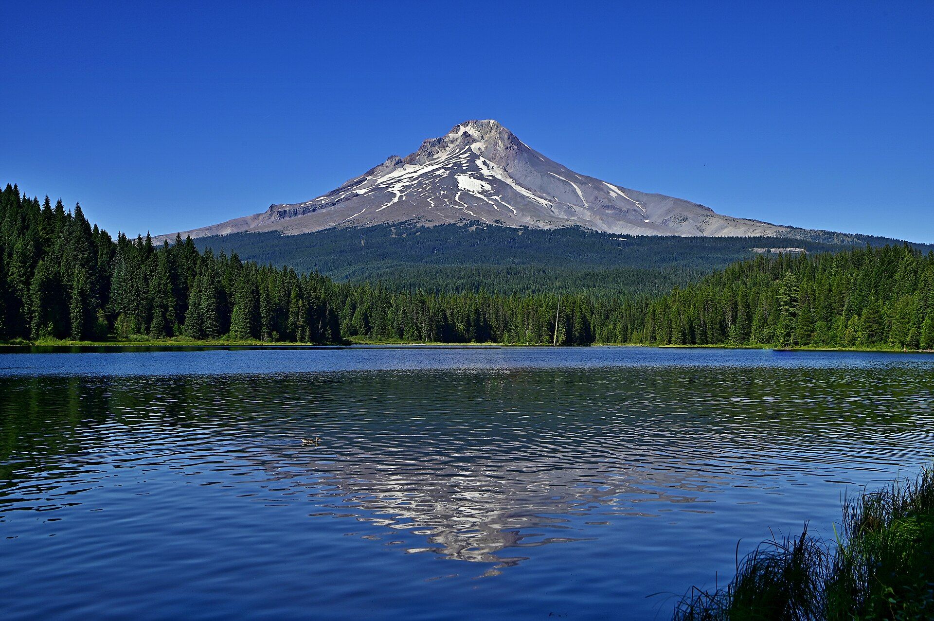
Oregon's highest mountain, 11,239 ft (3,426 m), is an active volcano with 11 glaciers and steaming vents near the summit. Its last major eruption came in the 1790s. A 38-mile trail circles it; every route to the top is a technical climb.
What makes it marvelous
Mount Hood is more than 500,000 years old and still warm inside: fumaroles near Crater Rock vent sulfurous steam, often seen as a plume on clear, cold, windless days, and the gas chemistry tells the US Geological Survey that magma lies a few miles below the summit. Unlike its neighbour Mount St. Helens, Hood has no history of violent explosive eruptions. It grew one sector at a time from lava flows and from lava domes that piled up over the vent, then collapsed into fast, very hot pyroclastic flows. Its last major eruption, in the 1790s, did exactly that — Crater Rock is the remnant of that dome — and poured so much volcanic sand into the Sandy River that Lewis and Clark named it the "Quicksand River" in 1806. About 100,000 years ago a collapse of the north flank and summit became a lahar that was 400 feet deep where the town of Hood River stands and crossed the Columbia River into Washington.
Why visit
A glaciated volcano you can reach from Portland: walk the meadows and glacial creeks of the 38-mile Timberline Trail, stay at the historic Timberline Lodge, or join a guided climb to the summit at sunrise.
Still deciding?
Mount Hood comes up most often against these — each one weighs cost, effort, season and crowds side by side.
- 🏔️ Denali vs Mount Rainier: Which Mountain Park Should You Visit?
- 🌋 Haleakalā vs Kīlauea: Which Hawaiʻi Volcano Should You Visit?
- 🗻 Mount Fuji vs Mount Rainier: Two Volcanoes Above Two Cities
- 🌋 Mount Hood vs Mount Rainier: Which Cascade Volcano Should You Visit?
- 🌋 Mount Hood vs Mount St. Helens: Which Volcano Should You Visit From Portland?
- 🏔️ Mount Rainier vs Olympic: Which Washington National Park Should You Visit?
- 🌋 Mount St. Helens vs Mount Rainier: Which Washington Volcano Should You Visit?
What to know before you go
🗓️ Best time
For hiking the Timberline Trail, wait for the snow to melt — unbridged glacial creeks run high and dangerous during snowmelt in early to mid-summer and after heavy rain, so check conditions and have a backup plan. Much of the area's 150 inches of yearly precipitation falls as snow between October and April. For a summit climb, the Forest Service says late spring and early summer are the most popular window; in late summer and fall, rockfall is significant and crevasses more exposed.
🧭 Getting there & access
Mount Hood sits in the 1.1-million-acre Mt. Hood National Forest, close to the Portland metro area, Hood River and The Dalles. The top several thousand feet of the mountain are the Mount Hood Wilderness, reached from trailheads including Timberline Lodge, Ramona Falls, Paradise Park, Elk Cove, Cloud Cap and Vista Ridge. Some trailheads charge a day-use fee, and an Oregon Sno-Park permit is required from 1 November to 30 April at sno-parks, including all Timberline parking lots.
Good to know
- Any travel above 9,500 ft needs a Mt. Hood Climbing Permit from the Forest Service, and every summit route — including the "easier" south side — is technical: crevasses, falling rock, ropes and crampons.
- South-side climbers aim to summit at sunrise and be off the rockfall areas before the day warms; many start between midnight and 2 a.m.
- Carry a WAG bag (free at the Climbers Registration area at Timberline) and pack out human waste; the group size limit on the mountain is 12.
- Check the Northwest Avalanche Center forecast — avalanches can happen in any month on Cascade peaks.
- Weekends bring most of the day hikers; mid-week and overnight visitors see far fewer people.
Natural riches of the area
- The summit, 11,239 ft (3,426 m) — Oregon's highest point
- 11 active glaciers
- Fumaroles near Crater Rock, the remnant of the 1790s lava dome
- The 38-mile Timberline Trail around the mountain
- Alpine meadows, more than a dozen waterfalls and Douglas-fir forest in the Mount Hood Wilderness
Local food
- Huckleberries
- Huckleberries grow in the forest understory on Mount Hood's lower slopes, alongside Oregon grape and salal.
Mount Hood is Oregon’s highest mountain: 11,239 feet (3,426 m), the US Geological Survey figure the Forest Service quotes. It is also an active volcano. Eleven glaciers hang on its flanks, and fumaroles near Crater Rock still vent sulfurous steam close to the summit — on clear, cold, still days the plume is often visible, and climbers frequently smell the rotten-egg gas.
The mountain is more than half a million years old and has grown in bursts, with decades to centuries of eruptions separated by quiet spells of centuries to more than 10,000 years. Its style is not Mount St. Helens’: rather than blowing apart, Hood builds lava domes that collapse into hot pyroclastic flows, which melt snow and ice into lahars that run down the river valleys. The last major eruption, in the 1790s, built the dome whose remnant is Crater Rock and choked the Sandy River with so much sediment that Lewis and Clark called it the “Quicksand River” in 1806. The USGS considers lahars the greatest hazard today, because more people live in the valleys downstream than on the mountain itself. Small lahars happen every few years even without an eruption — on Christmas Day 1980, rain-triggered debris in Polallie Creek killed a camper and destroyed five miles of highway.
For visitors, the mountain is the centre of Mt. Hood National Forest, close to Portland. The Timberline Trail circles it for 38 miles through alpine meadows and across glacial creeks that are dangerous to ford during snowmelt and heavy rain, and the historic Timberline Lodge is a National Historic Landmark. The summit is a different proposition: a Forest Service climbing permit above 9,500 feet, technical gear on every route, a pre-dawn start, and late spring or early summer for the best conditions.
Sources
Mount Hood: common questions
When is the best time to visit Mount Hood?
For hiking the Timberline Trail, wait for the snow to melt — unbridged glacial creeks run high and dangerous during snowmelt in early to mid-summer and after heavy rain, so check conditions and have a backup plan. Much of the area's 150 inches of yearly precipitation falls as snow between October and April. For a summit climb, the Forest Service says late spring and early summer are the most popular window; in late summer and fall, rockfall is significant and crevasses more exposed.
How do you get to Mount Hood?
Mount Hood sits in the 1.1-million-acre Mt. Hood National Forest, close to the Portland metro area, Hood River and The Dalles. The top several thousand feet of the mountain are the Mount Hood Wilderness, reached from trailheads including Timberline Lodge, Ramona Falls, Paradise Park, Elk Cove, Cloud Cap and Vista Ridge. Some trailheads charge a day-use fee, and an Oregon Sno-Park permit is required from 1 November to 30 April at sno-parks, including all Timberline parking lots.
Added