Acatenango
📍 Sacatepéquez and Chimaltenango Departments, near Antigua, Guatemala
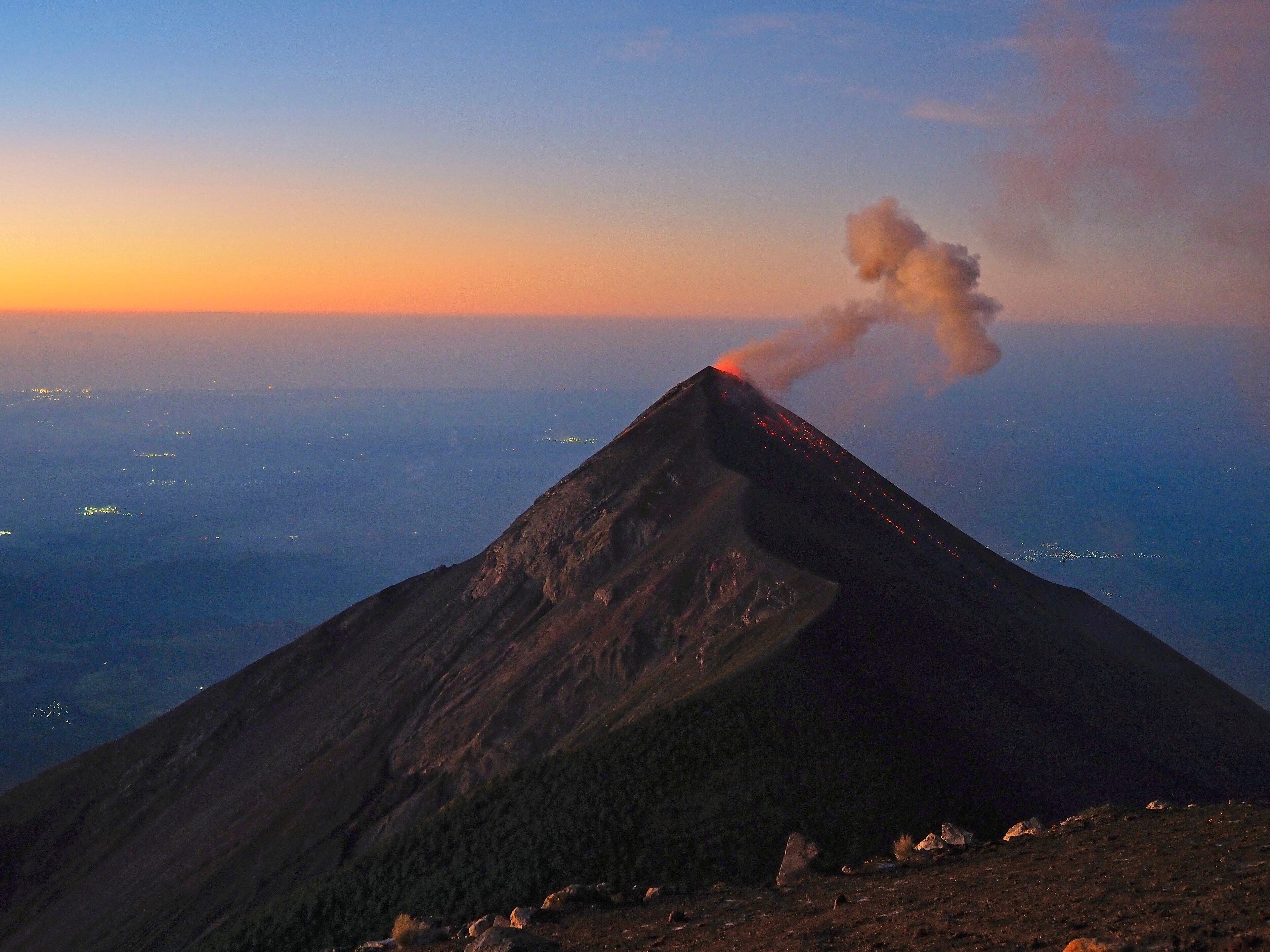
A 3,976-metre stratovolcano climbed almost entirely for the view of a different volcano — from its upper slopes you camp level with Fuego, one of the most active vents in Central America, and watch it erupt through the night.
What makes it marvelous
Acatenango and Volcán de Fuego are joined at the base into a single complex, known together as La Horqueta. The Fuego–Acatenango massif is a line of five or more vents running north to south, at right angles to the Central American Volcanic Arc, and the volcanism along it goes back more than 200,000 years, getting progressively younger toward the southern end. The whole complex stands more than 3,500 metres above the Pacific coastal plain and 2,000 above the Guatemalan highlands, and it has repeatedly collapsed: one prehistoric debris avalanche travelled over 50 kilometres and covered more than 300 square kilometres. Acatenango's summit, Pico Mayor, is 3,976 metres, with a second peak, Yepocapa, at 3,880. Its own eruptive record is quiet by comparison — phreatic explosions between 1924 and 1927 and again in December 1972 are the only historical events, with the last significant explosive eruptions about 1,900 and 2,300 years ago. Fuego, a few kilometres south and slightly lower, is doing something entirely different: erupting more or less continuously.
Why visit
The overnight climb is one of the very few places on Earth where you can sit at altitude, at eye level, and watch an active volcano erupt repeatedly through the night from a safe distance on a neighbouring peak. Camps sit on Acatenango's southern flank facing Fuego; after dark the ash plumes turn incandescent and the lava is visible running down the cone. Sunrise from the summit ridge takes in Agua, Pacaya, and on clear mornings the whole highland volcanic line.
What to know before you go
🗓️ Best time
November to April is the dry season and gives the clearest nights, which is what the trip is for. May to October brings cloud and rain that can hide Fuego entirely. Nights are cold at 3,700 metres in any month.
🧭 Getting there & access
Trailheads sit above La Soledad, roughly 1.5 to 2 hours by road from Antigua. Almost everyone goes with one of the many Antigua-based operators, which supply tents, food and porters; the ascent is around 5 to 6 hours to the camps and another hour to the summit ridge the following morning. Independent ascent is possible but not advised.
Good to know
- Check INSIVUMEH's current bulletin on Fuego before you go, and follow whatever your guide says about the boundary. Activity levels vary.
- The cold is what catches people out — it drops below freezing at camp and most operators' rental gear is thin. Bring your own layers.
- Antigua sits at 1,500 m and the camps at around 3,700. Spend a night or two in town first.
- Choose an operator on their group sizes and their safety record, not on price.
Plan your visit
Strenuous🧭 Getting there
From Guatemala City (GUA), then Antigua
- Fly into Guatemala City and transfer to Antigua
- Acclimatise a night or two at 1,500 m
- Drive 1.5–2 hours to the trailhead above La Soledad
- Climb 5–6 hours to camp, then the summit ridge before dawn
- Total travel
- About 2 hours from Antigua to the trailhead
- Time at site
- Two days and one night on the mountain
- Access
- Effectively all ascents run through Antigua operators, who handle the park fee, tents, food and porters. There is no fixed permit system for visitors, but access to the flanks facing Fuego is managed according to current activity — guides and CONRED follow INSIVUMEH's assessments and so should you.
🎒 What to bring & consider
- Genuinely warm layers, hat and gloves; it freezes at camp
- Boots with grip — the upper mountain is deep volcanic scree
- At least 3–4 litres of water carried up; there is none on the mountain
- A headtorch for the pre-dawn summit push
- Time in Antigua first to take the edge off the altitude
👁️ What to expect
- Crowds
- Popular and getting more so; multiple groups camp on the same flank on dry-season weekends.
- Conditions
- A long steep climb through farmland, then cloud forest, then loose ash and scree. Cold and windy at camp.
- Facilities
- Operator-run camps with tents and cooked food. Nothing permanent, no water, no toilets beyond basic arrangements.
- The view
- Fuego erupting against the pre-dawn sky from the Acatenango camps, with the lights of the coastal towns far below.
Times and requirements are approximate and change with season, weather, and local rules — confirm permits, fares, and schedules with operators before you travel.
Natural riches of the area
- Pico Mayor de Acatenango, 3,976 m — one of the highest summits in Guatemala
- The Fuego–Acatenango massif, a north–south line of five or more vents over 200,000 years old
- Neighbouring Volcán de Fuego, in near-continuous eruption
- Debris-avalanche deposits from prehistoric flank collapses covering over 300 km²
- Cloud forest on the lower flanks giving way to volcanic scree and alpine scrub
Local food
- Pepián
- A thick roasted-seed and chilli stew, one of Guatemala's defining dishes.
- Tamales
- Masa steamed in banana leaf, eaten across the highlands.
- Acatenango coffee
- The valley below the volcano is a designated Guatemalan coffee-growing region.
- Atol de elote
- A warm sweet maize drink — the thing you want at a cold camp.
People climb Acatenango to look at something else.
It is a serious mountain in its own right — 3,976 metres at Pico Mayor, a second summit at Yepocapa, and one of the higher points in Guatemala. But it is joined at the base to Volcán de Fuego, and Fuego is the reason for the trip. The two make a single complex the Guatemalans call La Horqueta, part of a line of five or more vents running north to south across the grain of the Central American Volcanic Arc. Volcanism along that line goes back more than 200,000 years and steps steadily southward as it goes: the older centres are at the north end, and Fuego, at the southern tip, is the youngest and by far the busiest.
Acatenango itself is comparatively quiet. Its only eruptions in the historical record are phreatic explosions between 1924 and 1927 and again in December 1972; its last major explosive eruptions were roughly 1,900 and 2,300 years ago. Fuego does not have quiet periods in the same sense. It erupts more or less continuously, throwing ash and incandescent material out of its summit crater at intervals measured in minutes to hours.
So the standard trip is an overnight one: five or six hours up through maize fields, then cloud forest, then loose volcanic scree, to camps on Acatenango’s southern flank that sit at around 3,700 metres and face directly across at Fuego’s cone. After dark the plumes go orange and you can watch material running down the slope opposite. In the morning you climb the last hour to the summit ridge for sunrise over Agua, Pacaya and the highland volcanic line.
It is worth being clear-eyed about what you are looking at. Fuego’s behaviour varies, and it is capable of far more than the routine strombolian activity that draws the crowds — its 2018 eruption was the deadliest in Guatemala in decades. Guatemala’s volcanological institute, INSIVUMEH, publishes activity bulletins, guides and the national disaster agency work to them, and the boundary of where groups can camp shifts accordingly. Check before you go, and take the guidance you are given on the mountain seriously.
Acatenango: common questions
How do you get to Acatenango?
From Guatemala City (GUA), then Antigua: Fly into Guatemala City and transfer to Antigua; Acclimatise a night or two at 1,500 m; Drive 1.5–2 hours to the trailhead above La Soledad; Climb 5–6 hours to camp, then the summit ridge before dawn. Total travel time: About 2 hours from Antigua to the trailhead.
When is the best time to visit Acatenango?
November to April is the dry season and gives the clearest nights, which is what the trip is for. May to October brings cloud and rain that can hide Fuego entirely. Nights are cold at 3,700 metres in any month.
How long should you spend at Acatenango?
Two days and one night on the mountain. Total travel time: About 2 hours from Antigua to the trailhead.
What should you bring to Acatenango?
Genuinely warm layers, hat and gloves; it freezes at camp Boots with grip — the upper mountain is deep volcanic scree At least 3–4 litres of water carried up; there is none on the mountain A headtorch for the pre-dawn summit push Time in Antigua first to take the edge off the altitude
Do you need a permit or guide for Acatenango?
Effectively all ascents run through Antigua operators, who handle the park fee, tents, food and porters. There is no fixed permit system for visitors, but access to the flanks facing Fuego is managed according to current activity — guides and CONRED follow INSIVUMEH's assessments and so should you.
Is Acatenango crowded, and what are conditions like?
Popular and getting more so; multiple groups camp on the same flank on dry-season weekends. A long steep climb through farmland, then cloud forest, then loose ash and scree. Cold and windy at camp. Facilities: Operator-run camps with tents and cooked food. Nothing permanent, no water, no toilets beyond basic arrangements.
Added
More wonders to explore