Crater Lake
📍 Oregon, USA
The deepest lake in the United States — a caldera of astonishing, luminous blue, formed when a great volcano collapsed and filled with nothing but rain and snow.
What makes it marvelous
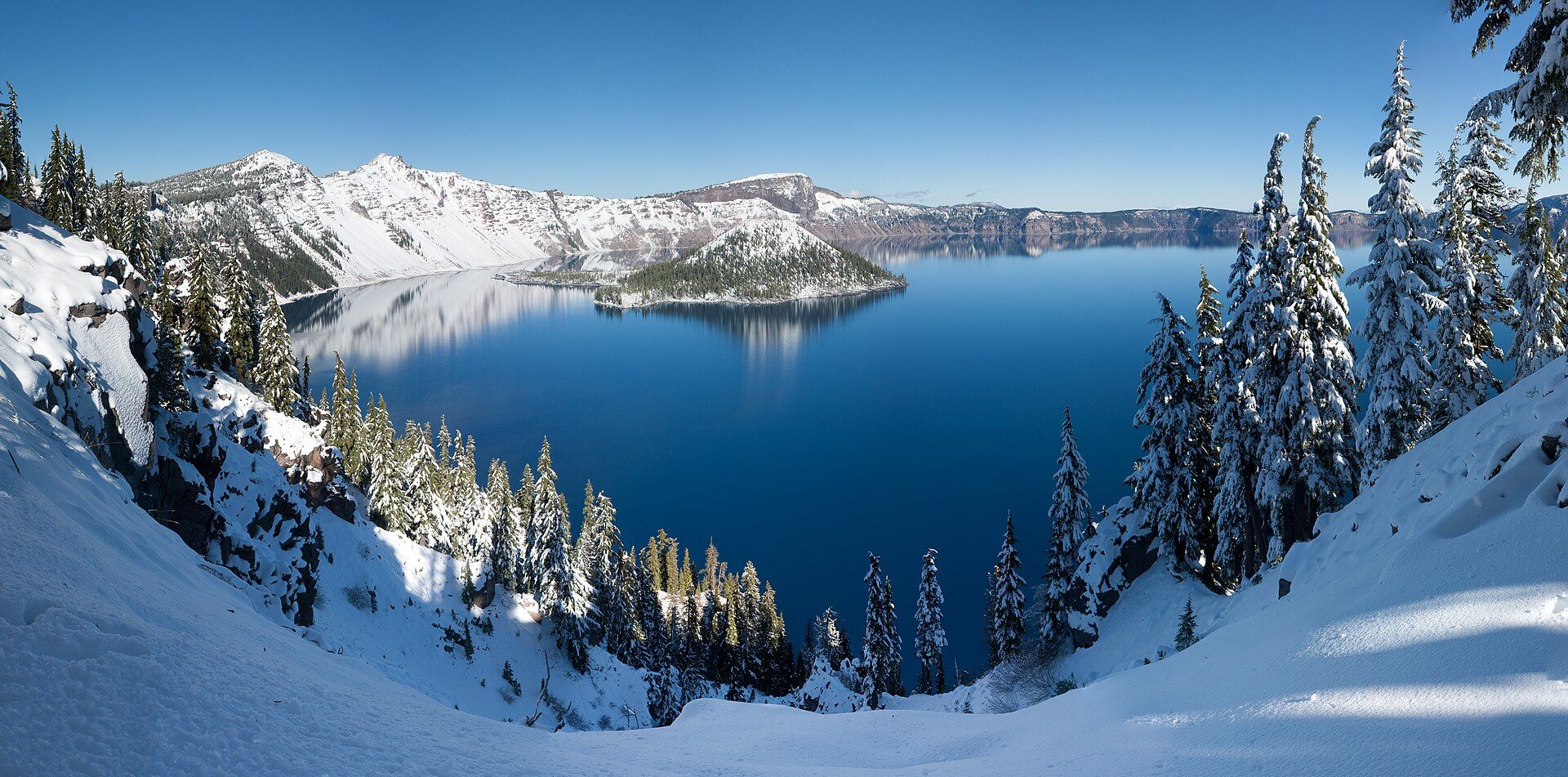
Crater Lake fills the caldera left when Mount Mazama, a towering volcano, erupted and collapsed on itself around 7,700 years ago. No rivers flow in or out; the basin has filled entirely with rain and snowmelt, and because that water is exceptionally pure and deep — 594 metres, the deepest lake in the United States — it absorbs almost every colour of light except an intense, almost unreal blue. Ringed by cliffs up to 600 metres high and punctuated by the cinder cone of Wizard Island, it is one of the clearest and most vividly coloured lakes on Earth. The Klamath people's oral history preserves an account of the mountain's collapse — one of the oldest surviving eyewitness records of a geological event anywhere.
Why visit
The first sight of Crater Lake — that impossibly blue water cupped in a ring of cliffs — stops people in their tracks. The rim drive, the hike down to the shore, and the sheer clarity of the water make it one of America's most singular natural sights.
Still deciding?
Crater Lake comes up most often against these — each one weighs cost, effort, season and crowds side by side.
What to know before you go
🗓️ Best time
Summer to early autumn (roughly July–September), when the rim road and trails are clear of snow; the caldera is buried in deep snow for much of the rest of the year.
🧭 Getting there & access
In southern Oregon, reached by road to Crater Lake National Park; the Rim Drive circles the caldera in summer, and the Cleetwood Cove trail is the only legal route down to the water and boat tours.
Good to know
- Visit July–September; the rim road is snowbound much of the year.
- Hike the Cleetwood Cove trail — the only access down to the lakeshore.
- Start early for the calmest water and best light on the blue.
Plan your visit
Easy🧭 Getting there
From Medford (MFR) or Klamath Falls, Oregon
- Fly to Medford
- Drive to the park — roughly 2h–2h30 from Medford, about 1h30 from Klamath Falls
- The Rim Drive circles the caldera once you are inside, when it is open
- Total travel
- Most of a day from the West Coast hubs
- Time at site
- A day for the Rim Drive and a viewpoint or two
- Access
- National park entrance fee. The real constraint is snow: Crater Lake receives an enormous annual snowfall, and most of the Rim Drive and the north entrance are closed for much of the year — commonly from around October until well into June or July. Only the south entrance and a short section stay open through winter. Check the park's road status before fixing a date.
🎒 What to bring & consider
- Warm layers whatever the month — the rim sits above 2,100m and snowbanks survive into summer
- Sun protection; glare off snow and water at altitude is severe
- Chains or winter tyres for anything outside high summer
- Food and water, since park services are limited and seasonal
- Sturdy shoes for the Cleetwood Cove trail, the only legal way down to the water and a hard climb back up
👁️ What to expect
- Crowds
- Rim viewpoints are busy through the short summer season, but the lake is large enough that it never feels overrun.
- Conditions
- Paved rim drive when open. The single trail to the shore is steep and gives back every metre on the way up.
- Facilities
- Lodge, cafe and visitor centre in summer; drastically reduced or shut the rest of the year.
- The view
- The blue is most intense under high sun and clear air — unusually, this is a place where noon beats golden hour. Regional wildfire smoke can wash it out entirely in late summer.
Times and requirements are approximate and change with season, weather, and local rules — confirm permits, fares, and schedules with operators before you travel.
Natural riches of the area
- The deepest lake in the USA (594 m)
- A volcanic caldera from the collapse of Mount Mazama
- Exceptionally pure, vividly blue water fed only by precipitation
- Wizard Island cinder cone and encircling cliffs
Local food
- Pacific Northwest fare
- Regional salmon, berries, and farm produce of Oregon.
- Wild huckleberries
- Gathered in the Cascade forests in late summer.
- Craft food & coffee
- Oregon's celebrated craft coffee and local cooking.
Crater Lake hardly looks real. In the mountains of southern Oregon, a ring of cliffs cups a sheet of water so intensely, luminously blue that first-time visitors often stop and stare. It fills the caldera left when the volcano Mount Mazama erupted and collapsed some 7,700 years ago — a catastrophe the Klamath people witnessed and preserved in their oral history.
No river feeds or drains it. The basin has filled entirely with rain and snowmelt, and because that water is so pure and so deep — 594 metres, the deepest lake in the United States — it swallows every colour of sunlight except a piercing blue. Cliffs rise up to 600 metres around the rim, the cinder cone of Wizard Island breaks the surface, and the clarity is extraordinary. It is one of the most vividly coloured and singular lakes anywhere on Earth.
Crater Lake: common questions
How do you get to Crater Lake?
From Medford (MFR) or Klamath Falls, Oregon: Fly to Medford; Drive to the park — roughly 2h–2h30 from Medford, about 1h30 from Klamath Falls; The Rim Drive circles the caldera once you are inside, when it is open. Total travel time: Most of a day from the West Coast hubs.
When is the best time to visit Crater Lake?
Summer to early autumn (roughly July–September), when the rim road and trails are clear of snow; the caldera is buried in deep snow for much of the rest of the year.
How long should you spend at Crater Lake?
A day for the Rim Drive and a viewpoint or two. Total travel time: Most of a day from the West Coast hubs.
What should you bring to Crater Lake?
Warm layers whatever the month — the rim sits above 2,100m and snowbanks survive into summer Sun protection; glare off snow and water at altitude is severe Chains or winter tyres for anything outside high summer Food and water, since park services are limited and seasonal Sturdy shoes for the Cleetwood Cove trail, the only legal way down to the water and a hard climb back up
Do you need a permit or guide for Crater Lake?
National park entrance fee. The real constraint is snow: Crater Lake receives an enormous annual snowfall, and most of the Rim Drive and the north entrance are closed for much of the year — commonly from around October until well into June or July. Only the south entrance and a short section stay open through winter. Check the park's road status before fixing a date.
Is Crater Lake crowded, and what are conditions like?
Rim viewpoints are busy through the short summer season, but the lake is large enough that it never feels overrun. Paved rim drive when open. The single trail to the shore is steep and gives back every metre on the way up. Facilities: Lodge, cafe and visitor centre in summer; drastically reduced or shut the rest of the year.
Added Updated
More wonders to explore