Al Wahbah Crater
📍 Harrat Kishb, Makkah Province, western Saudi Arabia
A two-kilometre hole in the Arabian desert with a floor of white salt crystals — long assumed to be a meteorite crater, and in fact the scar of a steam explosion from below.
What makes it marvelous
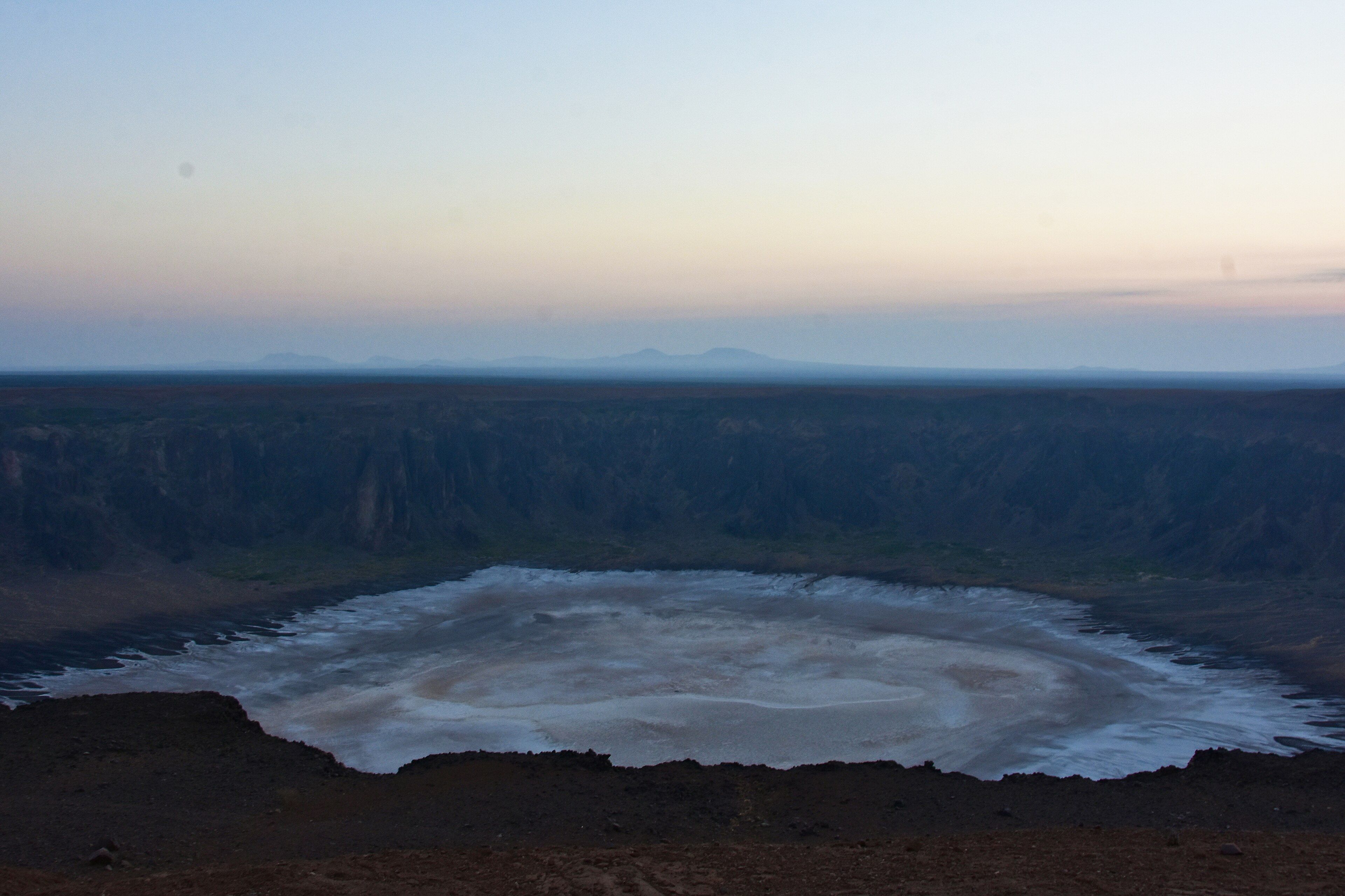
Al Wahbah sits on the western edge of the Harrat Kishb basalt plateau, a volcanic field studded with cones. The crater is about two kilometres across and 250 metres deep, with near-vertical walls around most of its circumference, and its floor is covered in a flat white crust of sodium phosphate crystals that reads from the rim as a frozen lake. Because of its circular form and steep sides it was widely believed to be an impact crater, and it does look remarkably like Arizona's Barringer Crater. Geologists now agree it is not. It is a maar: the product of a phreatic eruption, in which rising basaltic magma met groundwater and flashed it to steam, blowing a crater out of the rock without ever building a cone. The energy came from underneath, not from space — and the difference is written in the rock around the rim, which is shattered country rock and volcanic debris rather than shocked impact material.
Why visit
Very few volcanic craters anywhere are this clean, this large and this easy to stand on the edge of. The white crystal floor against black basalt walls is a genuinely strange thing to look at, and there is a prepared path down the northern side if you want to walk onto it. It also sits in the middle of a much bigger volcanic landscape most visitors to Saudi Arabia never see.
What to know before you go
🗓️ Best time
October to March. The crater is in open desert with no shade and summer temperatures make the descent dangerous. Sunrise and late afternoon give the best light on the walls and the coolest walking.
🧭 Getting there & access
Roughly 250 km from Taif, or around four hours by road from Jeddah, on the edge of the Harrat Kishb plateau. The last stretch is desert road; a high-clearance vehicle is sensible. The rim can be driven to, and a prepared path descends from the north side — most of the rest of the circumference is unclimbable cliff.
Good to know
- Descend early. Going down takes 45 to 60 minutes; coming back up takes 60 to 90, in full sun.
- The path on the north side is the only sane way in and out. Do not improvise a route down the cliffs.
- Carry far more water than you expect to drink — there is none anywhere on site.
- Walk the rim as well as the floor; the shape only makes sense from above.
Plan your visit
Moderate🧭 Getting there
From Jeddah (JED) or Taif, Saudi Arabia
- Fly into Jeddah
- Drive east to Taif
- Continue roughly 250 km northeast across the Harrat Kishb plateau
- Park on the rim and descend by the northern path
- Total travel
- Most of a day from Jeddah
- Time at site
- A full day, or an overnight camp on the rim
- Access
- The site is open and free, with picnic shelters and a low wall along part of the rim. There is no ticket office, no water and no staff. Self-drive is the only realistic way in; check your vehicle and fuel before the last stretch.
🎒 What to bring & consider
- Several litres of water per person, minimum — none is available on site
- Sun protection and a hat; the crater floor is fully exposed
- Shoes with grip for a loose, steep descent
- A high-clearance vehicle and a full tank
- Everything you need to camp, if you plan to stay for sunrise
👁️ What to expect
- Crowds
- Very light, even at weekends. You will often have the rim to yourself.
- Conditions
- Hot, dry and bright. A steep 250 m descent on loose ground, then flat crystal crust.
- Facilities
- Picnic shelters and a stone wall on part of the rim. Nothing else.
- The view
- The white crater floor against the dark rim walls in the first light, from the high ground on the southern edge.
Times and requirements are approximate and change with season, weather, and local rules — confirm permits, fares, and schedules with operators before you travel.
Natural riches of the area
- A maar crater about 2 km across and 250 m deep
- A floor crusted with white sodium phosphate crystals
- The Harrat Kishb basalt plateau and its volcanic cones surrounding it
- Springs on the northern side, with disused date palms partway down the wall
- Exposed crater-wall stratigraphy showing the explosion's ejecta
Local food
- Kabsa
- Spiced rice with lamb or chicken, the standard Saudi communal dish.
- Jareesh
- Crushed wheat cooked slowly with meat and yoghurt into a thick porridge.
- Taif roses and honey
- The Taif highlands nearby are known for both; honey is sold along the roads.
- Gahwa and dates
- Cardamom-scented coffee with dates — offered everywhere, and declining is odd.
Two kilometres wide, two hundred and fifty metres deep, near-circular, sheer-walled, with a flat white floor that from the rim looks like a salt lake or a frozen one. Al Wahbah is exactly the sort of feature that gets explained by the most dramatic mechanism available, and for a long time it was: it was widely taken to be a meteorite crater, largely because it looks so much like the Barringer Crater in Arizona, which is one.
It isn’t. Geologists now agree Al Wahbah is a maar — a crater blown out from below rather than punched in from above. It sits on the edge of Harrat Kishb, a basalt plateau covered in volcanic cones, and what happened here was a phreatic eruption: basaltic magma working upward met groundwater, flashed it instantly to steam, and the resulting explosion excavated a hole in the surrounding rock. No cone was ever built. The evidence is in the rim, which is shattered country rock and volcanic ejecta rather than the shock-metamorphosed material an impact leaves behind.
The white floor is sodium phosphate, crusted flat across the base of the bowl. Partway down the northern wall there are springs, and beside them the remains of date palms that someone once farmed there and no longer does. A prepared path drops from the north rim to the floor — the rest of the circumference is cliff, and not a negotiable one.
It is a straightforward place to visit and an unforgiving one to be careless at. The descent takes about an hour; the climb back out takes longer, and in this landscape there is no water, no shade and nobody else around. Go in winter, go at first light, and carry more than you think you need.
Al Wahbah Crater: common questions
How do you get to Al Wahbah Crater?
From Jeddah (JED) or Taif, Saudi Arabia: Fly into Jeddah; Drive east to Taif; Continue roughly 250 km northeast across the Harrat Kishb plateau; Park on the rim and descend by the northern path. Total travel time: Most of a day from Jeddah.
When is the best time to visit Al Wahbah Crater?
October to March. The crater is in open desert with no shade and summer temperatures make the descent dangerous. Sunrise and late afternoon give the best light on the walls and the coolest walking.
How long should you spend at Al Wahbah Crater?
A full day, or an overnight camp on the rim. Total travel time: Most of a day from Jeddah.
What should you bring to Al Wahbah Crater?
Several litres of water per person, minimum — none is available on site Sun protection and a hat; the crater floor is fully exposed Shoes with grip for a loose, steep descent A high-clearance vehicle and a full tank Everything you need to camp, if you plan to stay for sunrise
Do you need a permit or guide for Al Wahbah Crater?
The site is open and free, with picnic shelters and a low wall along part of the rim. There is no ticket office, no water and no staff. Self-drive is the only realistic way in; check your vehicle and fuel before the last stretch.
Is Al Wahbah Crater crowded, and what are conditions like?
Very light, even at weekends. You will often have the rim to yourself. Hot, dry and bright. A steep 250 m descent on loose ground, then flat crystal crust. Facilities: Picnic shelters and a stone wall on part of the rim. Nothing else.
Added