Mount St. Helens
📍 Cascade Range, south-west Washington, USA, about 70 miles north of Portland, Oregon
The Cascade volcano that blew open on 18 May 1980, when the largest debris avalanche in recorded history tore off its summit and a lateral blast flattened forests up to 19 miles away. Its open crater, lava dome and recovering blast zone are a national volcanic monument.
What makes it marvelous
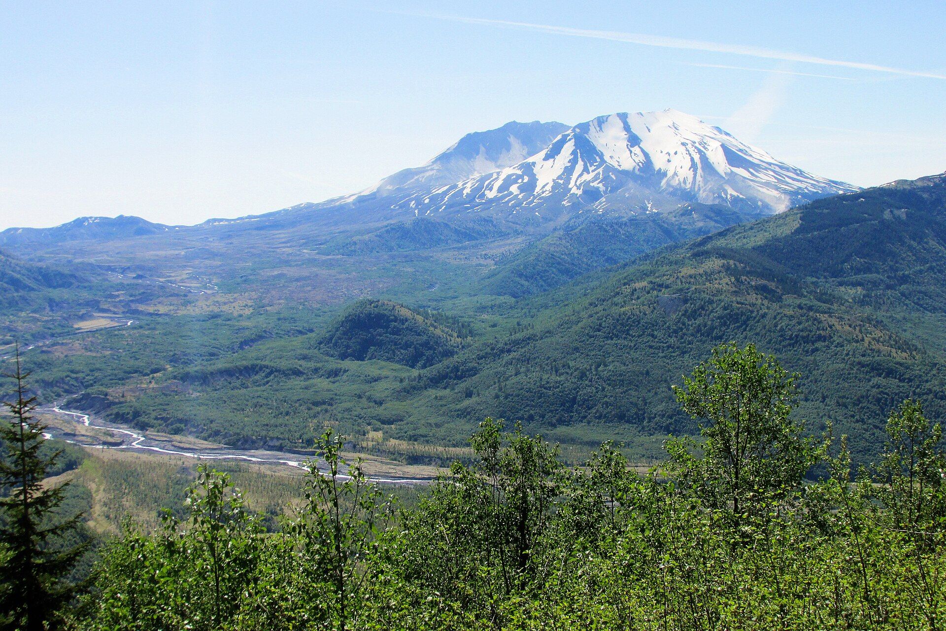
Before 1980, Mount St. Helens was a near-perfect cone, sometimes called the Mount Fuji of America. At 8:32 on the morning of 18 May 1980, an earthquake set off a collapse of its bulging north flank. The US Geological Survey calls it the largest debris avalanche in recorded history. It surged 13 miles down the North Fork Toutle River at up to 180 mph and buried the valley 150 ft deep. The lateral blast that followed flattened forests as far as 19 miles from the volcano and laid waste to more than 200 square miles of forest. Fifty-seven people were killed. The collapse removed the upper 400 m (1,300 ft) of the summit and left a horseshoe-shaped crater 2 by 3.5 km, open to the north. A lava dome has since grown inside it, along with a glacier. The volcano erupted again from 2004 to 2008, when spines of hot, solid lava pushed up through the crater floor. It has been the most active volcano in the Cascade Range during the Holocene, and the USGS rates its threat potential as very high.
Why visit
Look straight into the open crater of a volcano that blew apart within living memory, across a blast zone where the land is still visibly recovering — or climb to the crater rim on a permit for the view down onto the lava dome.
Still deciding?
Mount St. Helens comes up most often against one other place — each one weighs cost, effort, season and crowds side by side.
What to know before you go
🗓️ Best time
The monument operates daily from mid-May through October, and most trails are open from June through October, when the snow has gone; some lower-elevation trails are open all year. Summer is the main season for the crater-rim climb and for the north-side viewpoints.
🧭 Getting there & access
Mount St. Helens National Volcanic Monument is managed by the USDA Forest Service in Gifford Pinchot National Forest. The north side is reached by State Route 504, the Spirit Lake Memorial Highway, from Castle Rock on Interstate 5; Johnston Ridge Observatory lies at its end, 52 miles east of Castle Rock. A landslide on 14 May 2023 destroyed the Spirit Lake Outlet Bridge and cut the upper highway. In early 2026 the road was closed between mileposts 45.2 and 51, with Johnston Ridge Observatory and Loowit Viewpoint unreachable by car. WSDOT expected to finish the new bridge in fall 2026, and the Forest Service will then need to restore the observatory. Coldwater Lake, the Coldwater Science & Learning Center and the Hummocks Trail stayed open. A climbing permit is required to go above 4,800 ft, including the summit climb.
Good to know
- Check the Forest Service alerts page for Gifford Pinchot National Forest and WSDOT before you drive SR 504 — the upper highway and Johnston Ridge Observatory have been closed since the 2023 landslide.
- You need a climbing permit to go above 4,800 ft; plan the crater-rim climb for summer, when the route is free of snow.
- Most monument trails open only from June to October; outside that window, stick to low-elevation trails.
- Check the USGS Cascades Volcano Observatory (usgs.gov/volcanoes/mount-st.-helens) for current activity — the volcano is monitored continuously.
Plan your visit
Moderate🧭 Getting there
From Portland (PDX), Oregon, or Seattle–Tacoma (SEA), Washington
- Fly into Portland or Seattle–Tacoma
- Drive Interstate 5 to Castle Rock, Washington
- Turn east on State Route 504 (Spirit Lake Memorial Highway) toward Coldwater Lake and, when the upper highway is open, Johnston Ridge Observatory
- Total travel
- About 70 miles from Portland to the monument; Johnston Ridge Observatory is 52 miles east of Castle Rock along SR 504
- Time at site
- A full day for the north-side viewpoints and trails; a separate long day for the permit climb to the crater rim; a few hours for Ape Cave on the south side
- Access
- Johnston Ridge Observatory has an entrance fee ($8 at the time of writing); there is no fee to drive within the monument. A climbing permit is required above 4,800 ft. Upper SR 504 has been closed since the May 2023 landslide; WSDOT expected to finish a new bridge in fall 2026, after which the Forest Service must restore Johnston Ridge Observatory. Check the Gifford Pinchot National Forest alerts page and WSDOT before travelling, and the USGS Cascades Volcano Observatory for the volcano's status.
🎒 What to bring & consider
- A climbing permit if you plan to go above 4,800 ft
- Sun protection and plenty of water — the blast zone has little shade
- Layers and rain gear for changeable Cascade weather
- A headlamp and warm layers for Ape Cave
👁️ What to expect
- Crowds
- The monument season runs from mid-May through October, and summer is the main season for the north-side viewpoints and the crater-rim climb.
- Conditions
- Open, exposed trails across pumice and debris in the blast zone; the permit climb to the crater rim is a long, steep ascent.
- Facilities
- The Coldwater Science & Learning Center and the Coldwater Lake day-use area on SR 504; Johnston Ridge Observatory is closed until road access is restored and repairs are complete.
- The view
- The open north side of the crater, with the lava dome steaming inside, framed above the hummocks of the Toutle valley.
Times and requirements are approximate and change with season, weather, and local rules — confirm permits, fares, and schedules with operators before you travel.
Natural riches of the area
- The 1980 horseshoe-shaped crater, 2 × 3.5 km, open to the north
- The lava dome and the young glacier growing inside the crater
- The blast zone and the hummocky debris-avalanche deposits of the North Fork Toutle River valley
- Spirit Lake and Coldwater Lake
- Ape Cave, a lava tube about 2.5 miles (4 km) long, formed about 1,895 years ago
Local food
- Pacific Northwest salmon
- Grilled, smoked or planked salmon, a staple of the towns along the Columbia River and Interstate 5.
- Huckleberries
- Wild mountain huckleberries of the Cascades, picked in late summer and baked into pies or made into jam.
Mount St. Helens was once a smooth, symmetrical cone, sometimes called the Mount Fuji of America. That changed at 8:32 on the morning of 18 May 1980. An earthquake set off a landslide on the volcano’s swollen north flank, which had been bulging outward for weeks. The US Geological Survey calls the result the largest debris avalanche in recorded history. It raced 13 miles down the North Fork Toutle River at up to 180 miles an hour and buried the valley 150 feet deep. The lateral blast that followed flattened forests as far as 19 miles away and laid waste to more than 200 square miles of forest. Mudflows came by mid-morning and pyroclastic flows later in the day. Fifty-seven people died, among them USGS volcanologist David Johnston, after whom Johnston Ridge is named.
The eruption removed the upper 400 metres (1,300 feet) of the summit and left a horseshoe-shaped crater about 2 by 3.5 kilometres, open to the north. A lava dome now partly fills it, along with a glacier. In late September 2004 the volcano woke again. After small steam-and-ash explosions in early October, spines of hot, solid lava began pushing up through the crater floor, and dome-building went on until 2008. A 2009 lidar survey put the highest point at 2,539 metres (8,330 feet), lower than in 1982 because rock keeps falling from the crater walls. Mount St. Helens began forming about 275,000 years ago and has been the most active volcano in the Cascade Range during the Holocene.
In 1982 the area became Mount St. Helens National Volcanic Monument, 110,000 acres managed by the USDA Forest Service. The land hit by the eruption is left to recover naturally, for research, recreation and education. On the south side, Ape Cave is a lava tube about 2.5 miles long that formed about 1,895 years ago. It is the third-longest lava tube in North America. A permit is required for any climb above 4,800 feet, including the summit route to the crater rim.
Check access before you go. A landslide in May 2023 destroyed the Spirit Lake Outlet Bridge on State Route 504 and cut road access to Johnston Ridge Observatory. WSDOT expected the new bridge to be finished in fall 2026, but the observatory needs repairs before it can reopen. Coldwater Lake, the Coldwater Science & Learning Center and the Hummocks Trail stayed open, and Johnston Ridge could still be reached on foot.
Mount St. Helens: common questions
How do you get to Mount St. Helens?
From Portland (PDX), Oregon, or Seattle–Tacoma (SEA), Washington: Fly into Portland or Seattle–Tacoma; Drive Interstate 5 to Castle Rock, Washington; Turn east on State Route 504 (Spirit Lake Memorial Highway) toward Coldwater Lake and, when the upper highway is open, Johnston Ridge Observatory. Total travel time: About 70 miles from Portland to the monument; Johnston Ridge Observatory is 52 miles east of Castle Rock along SR 504.
When is the best time to visit Mount St. Helens?
The monument operates daily from mid-May through October, and most trails are open from June through October, when the snow has gone; some lower-elevation trails are open all year. Summer is the main season for the crater-rim climb and for the north-side viewpoints.
How long should you spend at Mount St. Helens?
A full day for the north-side viewpoints and trails; a separate long day for the permit climb to the crater rim; a few hours for Ape Cave on the south side. Total travel time: About 70 miles from Portland to the monument; Johnston Ridge Observatory is 52 miles east of Castle Rock along SR 504.
What should you bring to Mount St. Helens?
A climbing permit if you plan to go above 4,800 ft Sun protection and plenty of water — the blast zone has little shade Layers and rain gear for changeable Cascade weather A headlamp and warm layers for Ape Cave
Do you need a permit or guide for Mount St. Helens?
Johnston Ridge Observatory has an entrance fee ($8 at the time of writing); there is no fee to drive within the monument. A climbing permit is required above 4,800 ft. Upper SR 504 has been closed since the May 2023 landslide; WSDOT expected to finish a new bridge in fall 2026, after which the Forest Service must restore Johnston Ridge Observatory. Check the Gifford Pinchot National Forest alerts page and WSDOT before travelling, and the USGS Cascades Volcano Observatory for the volcano's status.
Is Mount St. Helens crowded, and what are conditions like?
The monument season runs from mid-May through October, and summer is the main season for the north-side viewpoints and the crater-rim climb. Open, exposed trails across pumice and debris in the blast zone; the permit climb to the crater rim is a long, steep ascent. Facilities: The Coldwater Science & Learning Center and the Coldwater Lake day-use area on SR 504; Johnston Ridge Observatory is closed until road access is restored and repairs are complete.
Added