Canyonlands National Park
📍 Southeast Utah, USA, west and southwest of Moab, where the Green and Colorado rivers meet on the Colorado Plateau
Utah's largest national park: 337,598 acres of canyons cut by the Green and Colorado rivers, which split it into three districts with no road between them — the Island in the Sky mesa on cliffs over 1,000 ft high, the sandstone spires of The Needles, and the remote Maze.
What makes it marvelous
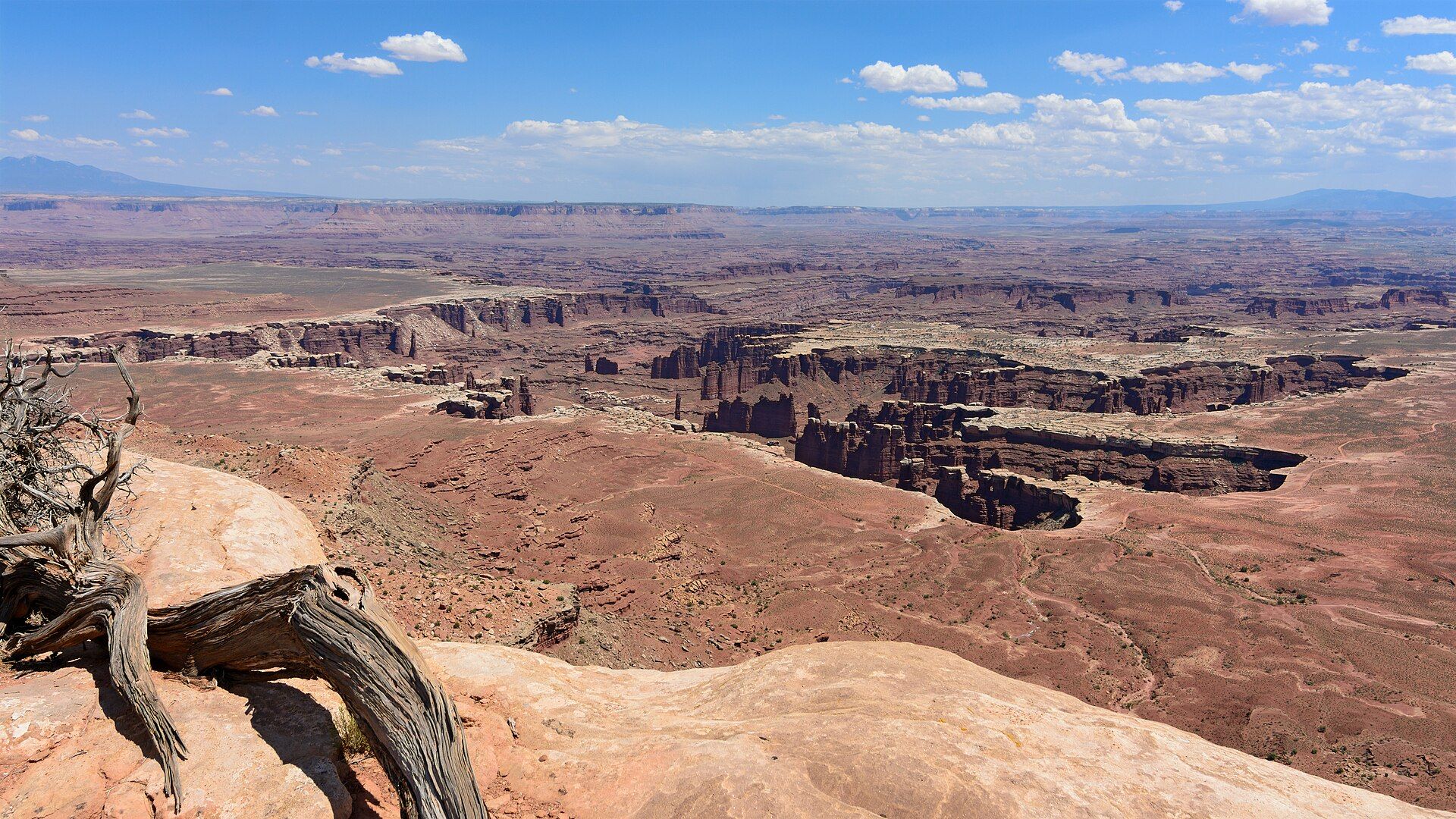
Canyonlands is a landscape of erosion. Most of its rock began as sediment carried from distant mountains and laid down near sea level, much of it nearly 300 million years ago; the Colorado Plateau has since been lifted to an average of more than 5,000 ft, and the Green and Colorado rivers have cut down through the layers as it rose. Softer layers wear away faster than harder ones, which gives the canyon walls their stair-step shape and leaves towers and balanced rocks where a hard cap protects weaker rock below — Monument Basin, seen from Grand View Point, is the park's showcase. The two rivers meet inside the park and divide it into three districts: Island in the Sky, a mesa resting on sheer sandstone cliffs more than 1,000 ft above the land around it; The Needles, named for its colourful spires of Cedar Mesa Sandstone; and The Maze, the least accessible district, where visitors rarely spend less than three days. No road crosses the rivers inside the park, so moving between districts takes two to six hours by car.
Why visit
Look down on Monument Basin and the White Rim from the overlooks of Island in the Sky, 40 minutes from Moab; hike among the striped spires of The Needles to Chesler Park or the Joint Trail; or commit to the 100-mile White Rim Road or the roadless canyons of The Maze — and stay for one of the darkest night skies in the United States.
Still deciding?
Canyonlands National Park comes up most often against these — each one weighs cost, effort, season and crowds side by side.
- 🏜️ Canyonlands vs Arches: Which Moab National Park Should You Visit (or Do Both)?
- 🏜️ Grand Canyon vs Bryce Canyon: Which Should You Visit?
- 🦅 Grand Canyon vs Colca Canyon: Famous vs Deep
- 🏜️ Grand Canyon vs Death Valley: Which Is Better From Las Vegas?
- 🏜️ Grand Canyon vs Fish River Canyon: America's and Africa's Great Chasms
- 🏜️ Grand Canyon vs Monument Valley: Is Monument Valley Worth the Extra Drive?
- 🏜️ Grand Canyon vs Zion: Which Should You Visit?
- 🏜️ Horseshoe Bend vs Antelope Canyon: Which to See From Page?
- 🏜️ Zion vs Bryce Canyon: Which Utah Park Should You Visit?
What to know before you go
🗓️ Best time
Spring (April–May) and fall (mid-September through October) are the temperate and most popular seasons, with daytime highs averaging 60–80°F (15–26°C). Summer often tops 100°F (37°C), and the late-summer monsoon brings violent storms and flash floods. Winters are cold, and even a little snow or ice can make trails and dirt roads impassable.
🧭 Getting there & access
Each district is reached separately. For Island in the Sky, drive 10 miles north of Moab on US 191, then 22 miles southwest on UT 313 (about 40 minutes from Moab to the visitor center). For The Needles, drive 40 miles south of Moab on US 191, then about 35 miles west on UT 211. The Maze is reached only by unpaved roads — the Hans Flat Ranger Station is 2.5 hours from Green River, then 3–6 more hours by high-clearance four-wheel drive. The nearest airport is Canyonlands Field (CNY), 16 miles from Moab; there is no public transport, and the park asks visitors to use a map rather than GPS.
Good to know
- No timed-entry reservation is needed to enter Canyonlands, but every visitor needs an entrance pass — confirm current prices with the National Park Service.
- Pick one or two districts: no roads cross the rivers inside the park, and driving between districts takes two to six hours.
- There is no food, fuel or lodging in the park, and The Maze has no water at all — bring what you need from Moab, Monticello or Green River.
- Every trip on the White Rim Road needs a permit (day-use or overnight) and a high-clearance, low-range four-wheel-drive vehicle; spring and fall overnight permits sell out early.
- The Horseshoe Canyon hike to the Great Gallery rock-art panel is 7 miles round trip with a 780 ft climb back out — dangerously hot in summer, so start early or after 4 pm.
Plan your visit
Easy🧭 Getting there
From Moab, Utah — Canyonlands Field (CNY) is 16 miles from town; Grand Junction (GJT) is 113 miles and Salt Lake City (SLC) 237 miles away
- Drive to Moab on US 191 (from I-70 or from the south via Monticello)
- For Island in the Sky, go 10 miles north on US 191 and 22 miles southwest on UT 313 — about 40 minutes
- For The Needles, go 40 miles south on US 191 and about 35 miles west on UT 211
- For The Maze, take UT 24 south from I-70, then 46 miles of dirt road to Hans Flat Ranger Station — high-clearance 4x4 beyond
- Total travel
- About 40 minutes from Moab to Island in the Sky; The Needles is a longer drive south; The Maze is a multi-day expedition
- Time at site
- Half a day to a day for the Island in the Sky overlooks; a day or more for Needles hikes; two to three days for the White Rim Road by 4x4; three days or more in The Maze
- Access
- Entrance pass required — confirm current prices with the National Park Service (nps.gov/cany). No timed-entry reservation. Permits needed for all White Rim trips and all overnight backcountry trips. Open 24 hours, year-round; The Needles Visitor Center closes in winter, and Island in the Sky Visitor Center has closed days from early January to early March.
🎒 What to bring & consider
- Everything you need for the day — water, food and fuel are not sold in the park
- A paper map; GPS units often send drivers the wrong way
- Sun protection and plenty of water; summer highs often exceed 100°F
- A permit and a high-clearance, low-range 4x4 for the White Rim Road or The Maze
👁️ What to expect
- Crowds
- Spring and fall are the busy seasons, when White Rim overnight permits often sell out; The Maze sees very few visitors.
- Conditions
- Paved scenic drives with short walks to overlooks at Island in the Sky; sandy, rocky backcountry trails and very difficult 4x4 roads elsewhere; temperatures can swing more than 40°F in a day.
- Facilities
- Visitor centers at Island in the Sky and The Needles, a ranger station at Hans Flat, two small campgrounds (12 sites at Island in the Sky, 26 at The Needles) — no lodging, food or fuel.
- The view
- Monument Basin's towers and the pale White Rim far below Grand View Point, with the canyons running out to the horizon.
Times and requirements are approximate and change with season, weather, and local rules — confirm permits, fares, and schedules with operators before you travel.
Natural riches of the area
- Monument Basin and the White Rim seen from Grand View Point at Island in the Sky
- Confluence of the Green and Colorado rivers
- Cedar Mesa Sandstone spires of The Needles: Chesler Park, Elephant Hill, the Joint Trail
- The Maze and the Doll House, the park's most remote canyons
- Gold-Tier International Dark Sky Park (2015)
Local food
- Supplies from Moab
- Moab is the base for both Island in the Sky and The Needles, and the only place nearby to stock up — there is no food for sale anywhere in the park.
Canyonlands National Park covers 337,598 acres of southeast Utah, making it the state’s largest national park. The Green and Colorado rivers wind through it and meet inside the park, and they split it into three districts — Island in the Sky, The Needles and The Maze — that no road links directly. Although they look close on a map, getting from one district to another takes two to six hours by car, so most visitors pick one or two.
Island in the Sky is the easiest to see in a short time. The mesa sits on sheer sandstone cliffs more than 1,000 feet above the surrounding terrain, about 40 minutes from Moab, and a paved scenic drive links overlooks such as Grand View Point, Shafer Canyon Overlook and Green River Overlook. Below the mesa, the 100-mile White Rim Road loops through the canyons; a four-wheel-drive trip usually takes two to three days and needs a permit. The Needles, in the park’s southeast corner, is named for its spires of Cedar Mesa Sandstone, with more than 60 miles of interconnecting trails to places such as Chesler Park, the Joint Trail and Confluence Overlook. The Maze, reached only by dirt roads, is the least accessible district; visitors rarely spend less than three days there and must be fully self-sufficient.
The landscape is the work of erosion. Rock laid down near sea level, much of it nearly 300 million years ago, has been lifted to more than 5,000 feet as the Colorado Plateau rose, and the rivers and summer storms have cut it into canyons, benches and towers. People have visited the area for more than 10,000 years; in Horseshoe Canyon, added to the park in 1971, the Great Gallery holds some of the most significant ancient rock markings in North America. The park’s skies are dark enough that it was named a Gold-Tier International Dark Sky Park in 2015.
Canyonlands National Park: common questions
How do you get to Canyonlands National Park?
From Moab, Utah — Canyonlands Field (CNY) is 16 miles from town; Grand Junction (GJT) is 113 miles and Salt Lake City (SLC) 237 miles away: Drive to Moab on US 191 (from I-70 or from the south via Monticello); For Island in the Sky, go 10 miles north on US 191 and 22 miles southwest on UT 313 — about 40 minutes; For The Needles, go 40 miles south on US 191 and about 35 miles west on UT 211; For The Maze, take UT 24 south from I-70, then 46 miles of dirt road to Hans Flat Ranger Station — high-clearance 4x4 beyond. Total travel time: About 40 minutes from Moab to Island in the Sky; The Needles is a longer drive south; The Maze is a multi-day expedition.
When is the best time to visit Canyonlands National Park?
Spring (April–May) and fall (mid-September through October) are the temperate and most popular seasons, with daytime highs averaging 60–80°F (15–26°C). Summer often tops 100°F (37°C), and the late-summer monsoon brings violent storms and flash floods. Winters are cold, and even a little snow or ice can make trails and dirt roads impassable.
How long should you spend at Canyonlands National Park?
Half a day to a day for the Island in the Sky overlooks; a day or more for Needles hikes; two to three days for the White Rim Road by 4x4; three days or more in The Maze. Total travel time: About 40 minutes from Moab to Island in the Sky; The Needles is a longer drive south; The Maze is a multi-day expedition.
What should you bring to Canyonlands National Park?
Everything you need for the day — water, food and fuel are not sold in the park A paper map; GPS units often send drivers the wrong way Sun protection and plenty of water; summer highs often exceed 100°F A permit and a high-clearance, low-range 4x4 for the White Rim Road or The Maze
Do you need a permit or guide for Canyonlands National Park?
Entrance pass required — confirm current prices with the National Park Service (nps.gov/cany). No timed-entry reservation. Permits needed for all White Rim trips and all overnight backcountry trips. Open 24 hours, year-round; The Needles Visitor Center closes in winter, and Island in the Sky Visitor Center has closed days from early January to early March.
Is Canyonlands National Park crowded, and what are conditions like?
Spring and fall are the busy seasons, when White Rim overnight permits often sell out; The Maze sees very few visitors. Paved scenic drives with short walks to overlooks at Island in the Sky; sandy, rocky backcountry trails and very difficult 4x4 roads elsewhere; temperatures can swing more than 40°F in a day. Facilities: Visitor centers at Island in the Sky and The Needles, a ranger station at Hans Flat, two small campgrounds (12 sites at Island in the Sky, 26 at The Needles) — no lodging, food or fuel.
Added
More wonders to explore