Antelope Canyon
📍 Navajo Nation, near Page, Arizona, United States
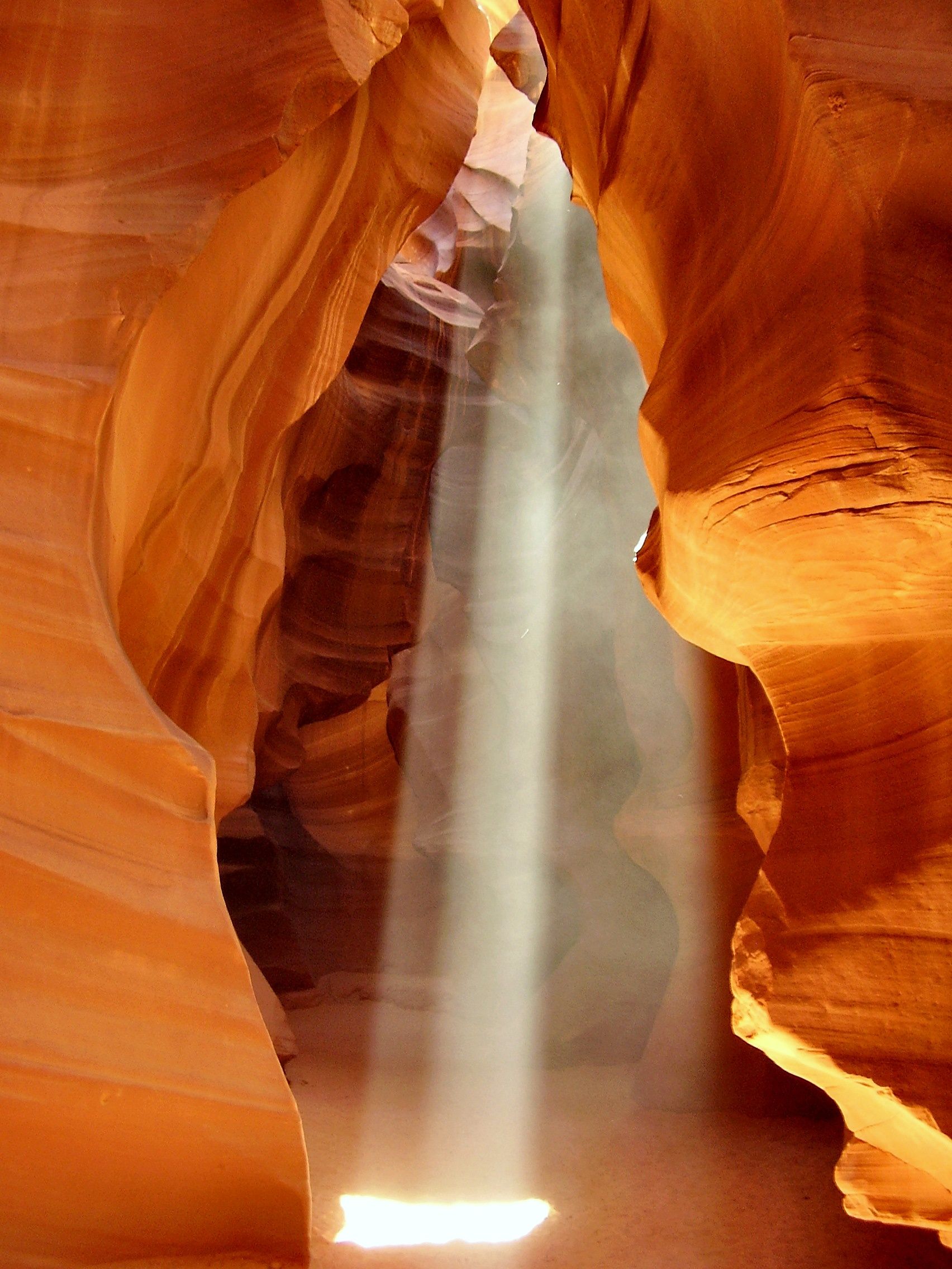
A slot canyon of flowing, sculpted sandstone walls glowing orange, purple, and gold — carved by flash floods into curving corridors where, at midday, shafts of sunlight spear down like beams of light.
What makes it marvelous
Antelope Canyon is a 'slot canyon', a narrow, deep passage cut into Navajo sandstone by the sudden, powerful flash floods that race through the Southwest in the rainy season. Over time the rushing, sediment-laden water has smoothed and swirled the rock into sensuous, flame-like curves. When the high summer sun is overhead, it pours through the narrow openings above as dramatic shafts of light against the glowing walls — the images that made the canyon world-famous. It lies on the Navajo Nation and is deeply significant to the Diné (Navajo) people.
Why visit
Walking through the curving, luminous corridors, the sandstone shifting from orange to violet as the light changes, is like stepping inside a piece of flowing sculpture. The famous light beams in the Upper Canyon are a photographer's dream, and Navajo guides share the place's cultural meaning.
Still deciding?
Antelope Canyon comes up most often against these — each one weighs cost, effort, season and crowds side by side.
What to know before you go
🗓️ Best time
Late spring to early autumn, and especially around midday in summer (roughly late March–October), when the sun is high enough to create the light beams. Access is closed during flash-flood risk.
🧭 Getting there & access
Near Page, Arizona, on the Navajo Nation. Entry is only by guided tour with authorised Navajo operators — independent visits are not permitted, for both cultural and safety reasons.
Good to know
- Book a Navajo-guided tour; independent entry isn't allowed.
- For the light beams, choose a midday summer tour of the Upper Canyon.
- Never enter in wet weather — flash floods in slot canyons are deadly.
Plan your visit
Easy🧭 Getting there
From Page, Arizona — Navajo Nation land
- Fly → Las Vegas (LAS) or Flagstaff (FLG), then drive to Page — roughly 4h30 from Las Vegas
- Drive Page → the Upper or Lower Antelope tour meeting point — about 10–15 minutes
- Guided tour through the slot — roughly 1h–1h30
- Total travel
- A long drive from any major airport; minutes once you are in Page
- Time at site
- About an hour in the canyon itself
- Access
- There is no independent access. The canyon is on Navajo Nation land and every visit is a booked, guided tour with an authorised operator — a rule that dates from the 1997 flash flood that killed eleven people in the lower canyon. Tours sell out weeks ahead in high season. Most operators now prohibit tripods and bags on standard tours. Confirm rules and availability directly with the Navajo Parks and Recreation authorised operators.
🎒 What to bring & consider
- A booking made well in advance, since walk-up availability effectively does not exist in the warm months
- The right clock: the Navajo Nation observes daylight saving time while the rest of Arizona does not, so in summer your phone may be an hour off the tour time. People miss slots over this every year
- The acceptance that a tour can be cancelled for rain falling many miles away, because the watershed that floods this slot is nowhere near the canyon
- A camera you can hold, given the tripod restrictions, and the willingness to shoot in a moving line of people
- Closed shoes for sand and, in Lower Antelope, steep metal ladders
👁️ What to expect
- Crowds
- Heavy and continuous. Groups move through on a schedule and you will rarely have a chamber to yourself.
- Conditions
- Warm, sandy and dim, with dust in the air. Lower Antelope involves ladders and tight squeezes; Upper is a level walk.
- Facilities
- At the tour offices in Page. Nothing at the canyon.
- The view
- The light beam dropping into Upper Antelope, which only appears around the middle of the day and only in the higher-sun months from roughly late March to early October. Photography-specific tours for it have been restricted in recent years, so check what is actually on offer before planning a trip around it.
Times and requirements are approximate and change with season, weather, and local rules — confirm permits, fares, and schedules with operators before you travel.
Natural riches of the area
- Wind- and water-sculpted Navajo sandstone
- Flash-flood-carved slot-canyon geology
- Part of the Colorado Plateau desert ecosystem
- A culturally significant site of the Navajo (Diné) Nation
Local food
- Navajo frybread & tacos
- A Southwest and Native American staple, from the Navajo Nation.
- Blue corn dishes
- Traditional Diné foods made from blue corn.
- Mutton stew
- A hearty traditional Navajo dish.
Antelope Canyon is a masterpiece carved by water in a hurry. It’s a slot canyon — a narrow, deep passage sliced into Navajo sandstone by the violent flash floods that tear through the Southwest after rain. Over countless floods, the sediment-laden water has smoothed and swirled the rock into flowing, flame-like curves, and the walls glow in shifting oranges, reds, purples, and gold as the light moves.
Its signature moment comes at midday in summer, when the high sun spears through the slots above and drops shafts of light against the luminous walls — the images that made the canyon famous around the world. It lies on the Navajo Nation and is significant to the Diné people, so it can only be visited on a guided tour with authorised Navajo operators — which is also wise for safety, since a slot canyon is the last place you want to be in a flash flood. Inside, it feels less like a canyon than like walking through flowing, living sculpture.
Two practical points are routinely got wrong. First, “Antelope Canyon” is two separate canyons a few kilometres apart, and they are not interchangeable: Upper is the wider, A-shaped one entered at ground level, where the famous light beams fall, reached by a shuttle ride across the sand; Lower is the narrower V, entered by climbing down steel ladders, and is generally the quieter and more physical of the two. Second, the beams are seasonal — they need a high sun, so they appear roughly from late March to early October and only around the middle of the day. Book well ahead; tours sell out. The safety rules are not theatre, either: on 12 August 1997 a flash flood, generated by a storm kilometres away under clear sky overhead, killed eleven visitors in Lower Antelope Canyon, and tours now close on the mere threat of rain.
Antelope Canyon: common questions
How do you get to Antelope Canyon?
From Page, Arizona — Navajo Nation land: Fly → Las Vegas (LAS) or Flagstaff (FLG), then drive to Page — roughly 4h30 from Las Vegas; Drive Page → the Upper or Lower Antelope tour meeting point — about 10–15 minutes; Guided tour through the slot — roughly 1h–1h30. Total travel time: A long drive from any major airport; minutes once you are in Page.
When is the best time to visit Antelope Canyon?
Late spring to early autumn, and especially around midday in summer (roughly late March–October), when the sun is high enough to create the light beams. Access is closed during flash-flood risk.
How long should you spend at Antelope Canyon?
About an hour in the canyon itself. Total travel time: A long drive from any major airport; minutes once you are in Page.
What should you bring to Antelope Canyon?
A booking made well in advance, since walk-up availability effectively does not exist in the warm months The right clock: the Navajo Nation observes daylight saving time while the rest of Arizona does not, so in summer your phone may be an hour off the tour time. People miss slots over this every year The acceptance that a tour can be cancelled for rain falling many miles away, because the watershed that floods this slot is nowhere near the canyon A camera you can hold, given the tripod restrictions, and the willingness to shoot in a moving line of people Closed shoes for sand and, in Lower Antelope, steep metal ladders
Do you need a permit or guide for Antelope Canyon?
There is no independent access. The canyon is on Navajo Nation land and every visit is a booked, guided tour with an authorised operator — a rule that dates from the 1997 flash flood that killed eleven people in the lower canyon. Tours sell out weeks ahead in high season. Most operators now prohibit tripods and bags on standard tours. Confirm rules and availability directly with the Navajo Parks and Recreation authorised operators.
Is Antelope Canyon crowded, and what are conditions like?
Heavy and continuous. Groups move through on a schedule and you will rarely have a chamber to yourself. Warm, sandy and dim, with dust in the air. Lower Antelope involves ladders and tight squeezes; Upper is a level walk. Facilities: At the tour offices in Page. Nothing at the canyon.
Added Updated
More wonders to explore