Horseshoe Bend
📍 Glen Canyon National Recreation Area, near Page, Arizona, USA
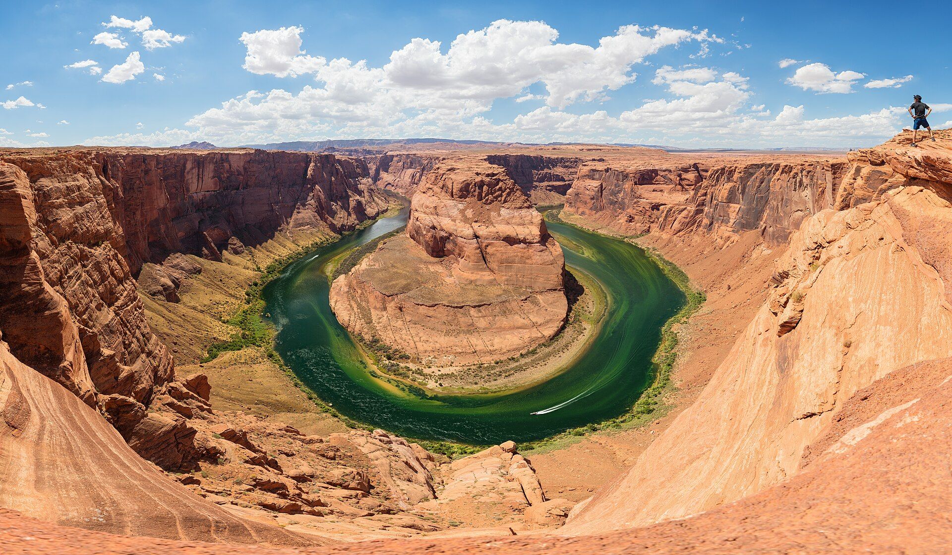
A perfect 270-degree meander of the Colorado River, seen from a sandstone rim about 1,000 ft (305 m) above the water — one of the most photographed views in the American Southwest.
What makes it marvelous
Just upstream of the Grand Canyon, the Colorado River swings almost all the way around a sandstone butte before turning back on itself. The result is a deep, horseshoe-shaped gorge cut through the red and cream Navajo Sandstone, with the green river roughly 1,000 ft (305 m) below the overlook. Seen from the rim, the whole loop fits in a single frame — which is exactly why it has become an icon.
Why visit
Few great views ask so little: a short walk across the desert brings you to the edge, and the entire bend opens beneath you. Sunrise and late afternoon paint the canyon walls in deep orange, and the river's colour shifts from jade to emerald with the light.
Still deciding?
Horseshoe Bend comes up most often against these — each one weighs cost, effort, season and crowds side by side.
What to know before you go
🗓️ Best time
Spring and autumn, when walking in the open desert is comfortable. In summer go early in the morning; the midday heat is dangerous and there is no shade or water on the trail.
🧭 Getting there & access
The trailhead sits just south of Page, Arizona, off US Highway 89. A hardened 1.5-mile (2.4 km) round-trip path leads to the overlook.
Good to know
- Carry water — there is none on the trail and almost no shade.
- Railings only cover the platform; stay well back from the unfenced rim.
- Parking is run by the City of Page and is paid; national park passes don't cover it.
Plan your visit
Easy🧭 Getting there
From Page, Arizona (PGA)
- Drive to Page, Arizona — about 4.5 hours from Las Vegas or Phoenix
- Follow US-89 south of town to the signed Horseshoe Bend parking area
- Walk the 1.5-mile (2.4 km) round-trip trail to the overlook
- Total travel
- A half-day stop, easily paired with Antelope Canyon
- Time at site
- 1–2 hours
- Access
- The parking lot is on City of Page land and charges a fee; America the Beautiful and NPS passes do not apply to parking. The trail is hardened, and railings line the overlook platform but not the rest of the rim.
🎒 What to bring & consider
- Plenty of water, even on a short visit
- Sun hat and sunscreen
- Shoes with grip on sandstone
- A wide-angle lens to fit the whole bend
👁️ What to expect
- Crowds
- Very busy, especially around sunset and in summer; early morning is quieter.
- Conditions
- Open desert with little shade; summer ground temperatures are extreme.
- Facilities
- Toilets at the parking lot only; nothing along the trail.
- The view
- The full loop from the rim in soft late-afternoon light, before the canyon floor falls into shadow.
Times and requirements are approximate and change with season, weather, and local rules — confirm permits, fares, and schedules with operators before you travel.
Natural riches of the area
- A 270° entrenched meander of the Colorado River
- Cliffs of Navajo Sandstone about 1,000 ft (305 m) deep
- Desert scrub and wildlife of the Colorado Plateau
Local food
- Navajo fry bread
- Page borders the Navajo Nation; fry bread and Navajo tacos are local staples.
- Southwest barbecue
- Smoked meats are a fixture of the Page dining scene.
Horseshoe Bend is the Colorado River caught in the act of carving a canyon. Here, a few miles downstream of Glen Canyon Dam, the river loops 270 degrees around a sandstone butte, leaving a gorge about 1,000 ft (305 m) deep that you can take in from a single viewpoint. The Grand Canyon itself begins only about nine miles further downstream.
The setting is the Navajo Sandstone that also forms nearby Antelope Canyon — wind-blown dunes turned to stone, now sliced open by the river. From the rim the walls glow orange against the green water, and the loop is so complete that the butte in the middle looks like an island.
It is also one of the easiest great views in the West. A hardened 1.5-mile round-trip trail crosses the open desert to an overlook with railings, and the rest of the rim is left natural. Treat that edge with respect, bring water, and come early or late: the light is better, and the crowds and heat are lower.
Horseshoe Bend: common questions
How do you get to Horseshoe Bend?
From Page, Arizona (PGA): Drive to Page, Arizona — about 4.5 hours from Las Vegas or Phoenix; Follow US-89 south of town to the signed Horseshoe Bend parking area; Walk the 1.5-mile (2.4 km) round-trip trail to the overlook. Total travel time: A half-day stop, easily paired with Antelope Canyon.
When is the best time to visit Horseshoe Bend?
Spring and autumn, when walking in the open desert is comfortable. In summer go early in the morning; the midday heat is dangerous and there is no shade or water on the trail.
How long should you spend at Horseshoe Bend?
1–2 hours. Total travel time: A half-day stop, easily paired with Antelope Canyon.
What should you bring to Horseshoe Bend?
Plenty of water, even on a short visit Sun hat and sunscreen Shoes with grip on sandstone A wide-angle lens to fit the whole bend
Do you need a permit or guide for Horseshoe Bend?
The parking lot is on City of Page land and charges a fee; America the Beautiful and NPS passes do not apply to parking. The trail is hardened, and railings line the overlook platform but not the rest of the rim.
Is Horseshoe Bend crowded, and what are conditions like?
Very busy, especially around sunset and in summer; early morning is quieter. Open desert with little shade; summer ground temperatures are extreme. Facilities: Toilets at the parking lot only; nothing along the trail.
Added
More wonders to explore