Yosemite Valley
📍 Sierra Nevada, California, United States
A glacier-carved granite valley of sheer cliffs and thundering waterfalls in California's Sierra Nevada — home to the monoliths of El Capitan and Half Dome, and groves of giant sequoias, the largest trees on Earth.
What makes it marvelous
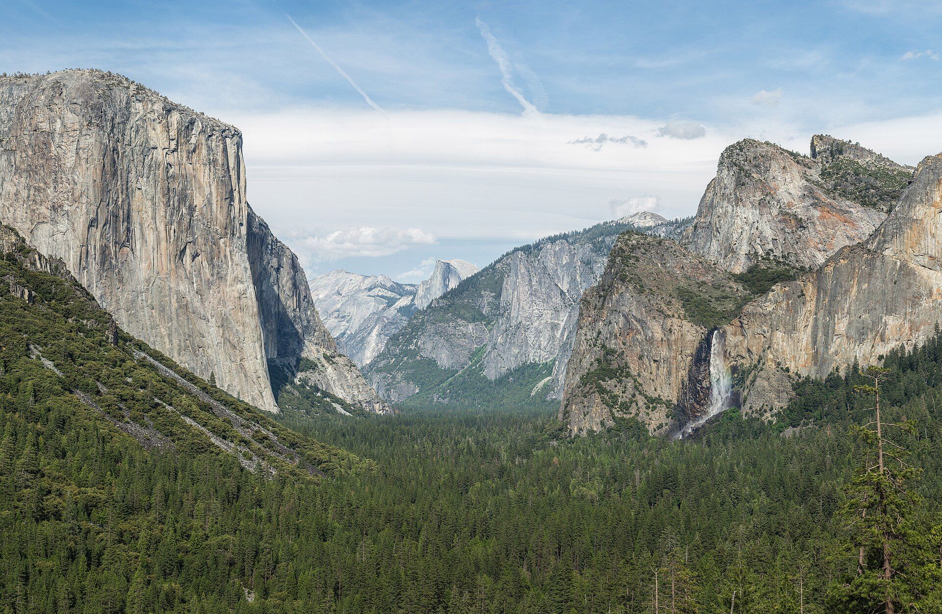
Yosemite Valley was sculpted by glaciers that ground through a river valley, leaving polished granite walls that rise almost vertically — including El Capitan, one of the largest exposed granite monoliths in the world, and the unmistakable dome of Half Dome. Snowmelt pours off the rim as some of the tallest waterfalls in North America, Yosemite Falls among them. Nearby groves shelter giant sequoias, the most massive living things on the planet. The park's landscapes helped inspire the American conservation movement.
Why visit
The valley delivers a concentrated hit of grandeur: 900-metre cliffs, free-falling waterfalls, meadows and the Merced River below, and world-famous rock climbing. Beyond it lie high country, alpine lakes, and the ancient sequoias — a lifetime of wilderness in one park.
Still deciding?
Yosemite Valley comes up most often against these — each one weighs cost, effort, season and crowds side by side.
- 🏔️ Denali vs Aconcagua: The Roofs of the Americas
- 🏔️ Denali vs Everest: The Tallest Mountain Is Not the Highest
- 💦 Lauterbrunnen vs Yosemite Valley: Two Great Glacial Valleys Compared
- 🌲 Redwoods vs Giant Sequoias: The Tallest Tree and the Largest Tree Are Not the Same
- 🏞️ Yosemite vs Yellowstone: Which National Park Should You Visit?
What to know before you go
🗓️ Best time
Late spring (May–June) for peak waterfalls from snowmelt; autumn for crisp weather and fewer crowds. High-country roads (Tioga) are seasonal, typically closed in winter.
🧭 Getting there & access
In California's Sierra Nevada, reached from the Central Valley or via the Tioga Road in summer. The valley has shuttle buses; timed-entry reservations may apply in peak season.
Good to know
- Come in late spring to catch the waterfalls at full flow — they can dwindle by late summer.
- Use the valley shuttle and reserve entry in busy months.
- Store food properly; black bears are active and clever.
Plan your visit
Moderate🧭 Getting there
From Fresno (FAT) or Merced, California
- Fly → Fresno (FAT), or drive from San Francisco — roughly 4h
- Drive Fresno → the South Entrance at Wawona — about 2h
- Drive on to Yosemite Valley — a further 1h
- Or take the YARTS bus from Merced or Fresno, which avoids the parking problem entirely
- Total travel
- Three to four hours from the nearest airports
- Time at site
- Three days for the valley; more if you add Tuolumne
- Access
- National park entry fee. Yosemite has operated peak-hours reservation requirements for entry in several recent seasons, with the rules revised year to year — this is the detail most likely to derail a trip, and it must be checked with the National Park Service for your specific dates rather than assumed. Half Dome cables require a separate permit awarded by lottery. Tioga Road and Glacier Point Road are closed by snow for much of the year, typically reopening late spring.
🎒 What to bring & consider
- Your entry reservation situation confirmed with the Park Service for your actual dates, well before you book accommodation
- A spring visit if the waterfalls are why you are going — Yosemite Falls peaks with snowmelt around May and can be bone dry by August, which surprises people every year
- Food in the provided lockers and nothing edible or scented left in the car, which is enforced and which black bears here are very good at exploiting
- Traction devices and warm layers in winter, plus chains carried in the car by law when conditions require
- The shuttle or a bicycle rather than a car inside the valley, where parking is the defining frustration of a summer visit
👁️ What to expect
- Crowds
- Very heavy in the valley from late spring through summer. Tuolumne Meadows and the high country are a different and far quieter park.
- Conditions
- Hot dry summers, snowbound winters, and a short spectacular snowmelt spring. Trails range from paved loops to serious granite.
- Facilities
- Extensive — lodging, campgrounds, shops, medical clinic and shuttle buses.
- The view
- Tunnel View is the classic and is busy at every hour. The Horsetail Fall glow in the second half of February needs snowmelt in the fall, a clear western horizon and luck, and it now draws such crowds that the park manages access to the viewing areas — check the arrangements before planning around it.
Times and requirements are approximate and change with season, weather, and local rules — confirm permits, fares, and schedules with operators before you travel.
Natural riches of the area
- Glacier-carved granite cliffs and domes
- Some of North America's tallest waterfalls
- Giant sequoia groves — the largest trees on Earth
- Sierra Nevada forests, meadows, and alpine lakes
Local food
- Sourdough & California produce
- The state's celebrated bread and farm produce from the nearby Central Valley.
- Trout
- Fresh Sierra Nevada mountain trout.
- Stone fruit & almonds
- Peaches, cherries, and almonds from California's orchards below the range.
Yosemite Valley is what happens when ice meets granite. Glaciers ground through an old river valley in California’s Sierra Nevada, shearing away the rock to leave near-vertical walls of pale granite — among them El Capitan, one of the largest granite monoliths on Earth and a magnet for climbers, and the sheer half-sphere of Half Dome. In spring, snowmelt throws itself off the rim as some of the tallest waterfalls on the continent.
There is more beyond the valley floor: high alpine country, meadows along the Merced River, and groves of giant sequoias — the most massive living things on the planet, some older than 2,000 years. It’s no accident that these landscapes helped spark the American conservation movement; few places make the case for protecting wild land more eloquently. Come in late spring for the waterfalls, and give yourself time to look up.
Timing decides what you actually see. Yosemite’s waterfalls are fed by snowmelt, not springs, so they peak around late May and hold through June — and by August, Yosemite Falls is frequently bone dry, which catches out a great many summer visitors who came for a picture taken in spring. Bridalveil, Vernal and Nevada hold some flow far later. The valley itself is a textbook glacial trough, ice having widened an older river-cut V into a U and plucked away the jointed granite to leave El Capitan’s roughly 900-metre face. Half Dome, despite the name, was never sliced in half: its missing side was carried off in pieces along fractures that were already there. Check the park service before driving up — peak-season entry has run on a timed-reservation system in recent years, and the Half Dome cables need their own lottery permit.
Yosemite Valley: common questions
How do you get to Yosemite Valley?
From Fresno (FAT) or Merced, California: Fly → Fresno (FAT), or drive from San Francisco — roughly 4h; Drive Fresno → the South Entrance at Wawona — about 2h; Drive on to Yosemite Valley — a further 1h; Or take the YARTS bus from Merced or Fresno, which avoids the parking problem entirely. Total travel time: Three to four hours from the nearest airports.
When is the best time to visit Yosemite Valley?
Late spring (May–June) for peak waterfalls from snowmelt; autumn for crisp weather and fewer crowds. High-country roads (Tioga) are seasonal, typically closed in winter.
How long should you spend at Yosemite Valley?
Three days for the valley; more if you add Tuolumne. Total travel time: Three to four hours from the nearest airports.
What should you bring to Yosemite Valley?
Your entry reservation situation confirmed with the Park Service for your actual dates, well before you book accommodation A spring visit if the waterfalls are why you are going — Yosemite Falls peaks with snowmelt around May and can be bone dry by August, which surprises people every year Food in the provided lockers and nothing edible or scented left in the car, which is enforced and which black bears here are very good at exploiting Traction devices and warm layers in winter, plus chains carried in the car by law when conditions require The shuttle or a bicycle rather than a car inside the valley, where parking is the defining frustration of a summer visit
Do you need a permit or guide for Yosemite Valley?
National park entry fee. Yosemite has operated peak-hours reservation requirements for entry in several recent seasons, with the rules revised year to year — this is the detail most likely to derail a trip, and it must be checked with the National Park Service for your specific dates rather than assumed. Half Dome cables require a separate permit awarded by lottery. Tioga Road and Glacier Point Road are closed by snow for much of the year, typically reopening late spring.
Is Yosemite Valley crowded, and what are conditions like?
Very heavy in the valley from late spring through summer. Tuolumne Meadows and the high country are a different and far quieter park. Hot dry summers, snowbound winters, and a short spectacular snowmelt spring. Trails range from paved loops to serious granite. Facilities: Extensive — lodging, campgrounds, shops, medical clinic and shuttle buses.
Added Updated
More wonders to explore