Svartifoss
📍 Skaftafell, Vatnajökull National Park, South Iceland
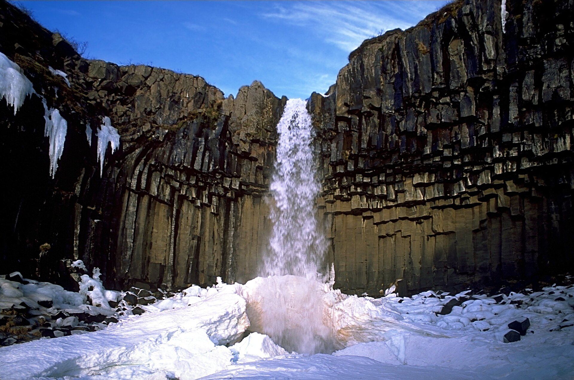
The 'Black Falls' — a slender 20-metre waterfall in Skaftafell framed by a wall of dark, hexagonal basalt columns that hang like organ pipes above the plunge pool, one of the most distinctive waterfalls in Iceland.
What makes it marvelous
Svartifoss owes its fame not to size but to its setting. The water drops about 20 metres over a cliff faced with hundreds of dark, geometric basalt columns — hexagonal pillars formed as a thick lava flow cooled slowly and cracked into near-perfect prisms. The columns splay outward and downward around the fall like the ribs of a fan or the pipes of an organ, and their sharp broken ends litter the base. The stark contrast of white water against black, angular rock gave the fall its name — Svartifoss, the Black Falls — and its columns famously inspired the architecture of Reykjavík's Hallgrímskirkja church and the National Theatre.
Why visit
This is the reward at the end of one of Iceland's most beloved short hikes, a walk up through the birch woods and past smaller falls in Skaftafell, on the southern edge of the vast Vatnajökull ice cap. The basalt colonnade makes it unlike any other waterfall in the country, and the trail continues to glacier viewpoints over Skaftafellsjökull for those who want more.
Still deciding?
Svartifoss comes up most often against these — each one weighs cost, effort, season and crowds side by side.
More views of Svartifoss
Additional photographs of the actual site — each freely licensed, with its photographer and licence credited.
What to know before you go
🗓️ Best time
Best June to September, when the Skaftafell trail is clear of snow and the woods are green; the hike is possible in winter but the path is icy and crampons are often needed.
🧭 Getting there & access
Reached on foot from the Skaftafell visitor centre in Vatnajökull National Park, off Route 1 (the Ring Road) about 320 km southeast of Reykjavík. It is a roughly 1.5 km uphill walk each way, around 45 minutes up.
Good to know
- Wear proper hiking shoes — the trail climbs steadily and can be muddy or icy.
- Carry on past the falls to the ridge viewpoints over Skaftafellsjökull glacier.
- Start early or late in summer to have the colonnade and viewpoint to yourself.
Plan your visit
Moderate🧭 Getting there
From Reykjavík (KEF), Iceland
- Drive the Ring Road (Route 1) southeast from Reykjavík about 320 km to Skaftafell
- Park at the Vatnajökull National Park (Skaftafell) visitor centre
- Follow the signed trail uphill about 1.5 km to the falls
- Total travel
- About 4h30–5h by road from Reykjavík one way; usually done as part of a south-coast trip
- Time at site
- 2–3h for the return hike, longer to add the glacier viewpoints
- Access
- A paid car park at the Skaftafell visitor centre; the falls are reached only on foot via a moderate uphill trail. The path is icy in winter and may need crampons — check conditions at the visitor centre.
🎒 What to bring & consider
- Sturdy hiking shoes for the uphill, sometimes muddy trail
- Wind and rain layers; mountain weather changes fast
- Water and a snack for the round-trip walk
- Traction spikes in shoulder season or winter
👁️ What to expect
- Crowds
- A popular hike but the climb thins the crowds; early and late are quietest.
- Conditions
- A steady 1.5 km uphill walk on a maintained path, muddy or icy in parts.
- Facilities
- Visitor centre, cafe, toilets, and campsite at the Skaftafell trailhead.
- The view
- Frame the white fall against the black basalt colonnade; overcast light keeps the columns from blowing out.
Times and requirements are approximate and change with season, weather, and local rules — confirm permits, fares, and schedules with operators before you travel.
Natural riches of the area
- Hexagonal basalt columns formed by slow-cooling lava
- The Stórilækur stream feeding the falls from the Vatnajökull ice cap
- Sub-Arctic birch and willow woodland in the Skaftafell valley
- The southern outlet glaciers of the Vatnajökull ice cap nearby
Local food
- Kjötsúpa (lamb soup)
- Hearty Icelandic lamb-and-root-vegetable soup, warming after the hike.
- Arctic char
- Cold-water fish from Icelandic lakes and rivers, often smoked or pan-fried.
- Skyr
- Thick Icelandic cultured dairy, eaten for centuries, served with berries or cream.
Svartifoss is proof that a waterfall doesn’t need to be big to be unforgettable. At about 20 metres it is modest by Icelandic standards, but it falls over a cliff faced with hundreds of dark basalt columns — hexagonal pillars formed when a thick lava flow cooled slowly and fractured into near-perfect geometric prisms. The columns fan outward around the drop like organ pipes or the ribs of a great dark fan, their snapped ends piled at the base, and the white thread of water against the near-black rock gives the fall its name: the Black Falls.
It sits in Skaftafell, a green pocket of birch woodland on the southern edge of the Vatnajökull ice cap, and reaching it is half the pleasure — a steady 1.5-kilometre climb from the visitor centre, past smaller falls and out to open views. The colonnade’s clean geometry so struck Icelandic architects that it shaped the design of Reykjavík’s Hallgrímskirkja church and the National Theatre. Walk a little further along the ridge and the valley opens onto the crevassed snout of Skaftafellsjökull, one of the glacier tongues spilling off the largest ice cap in Europe.
Svartifoss: common questions
How do you get to Svartifoss?
From Reykjavík (KEF), Iceland: Drive the Ring Road (Route 1) southeast from Reykjavík about 320 km to Skaftafell; Park at the Vatnajökull National Park (Skaftafell) visitor centre; Follow the signed trail uphill about 1.5 km to the falls. Total travel time: About 4h30–5h by road from Reykjavík one way; usually done as part of a south-coast trip.
When is the best time to visit Svartifoss?
Best June to September, when the Skaftafell trail is clear of snow and the woods are green; the hike is possible in winter but the path is icy and crampons are often needed.
How long should you spend at Svartifoss?
2–3h for the return hike, longer to add the glacier viewpoints. Total travel time: About 4h30–5h by road from Reykjavík one way; usually done as part of a south-coast trip.
What should you bring to Svartifoss?
Sturdy hiking shoes for the uphill, sometimes muddy trail Wind and rain layers; mountain weather changes fast Water and a snack for the round-trip walk Traction spikes in shoulder season or winter
Do you need a permit or guide for Svartifoss?
A paid car park at the Skaftafell visitor centre; the falls are reached only on foot via a moderate uphill trail. The path is icy in winter and may need crampons — check conditions at the visitor centre.
Is Svartifoss crowded, and what are conditions like?
A popular hike but the climb thins the crowds; early and late are quietest. A steady 1.5 km uphill walk on a maintained path, muddy or icy in parts. Facilities: Visitor centre, cafe, toilets, and campsite at the Skaftafell trailhead.
Added
More wonders to explore