Gullfoss
📍 Hvítá river, Southwest Iceland
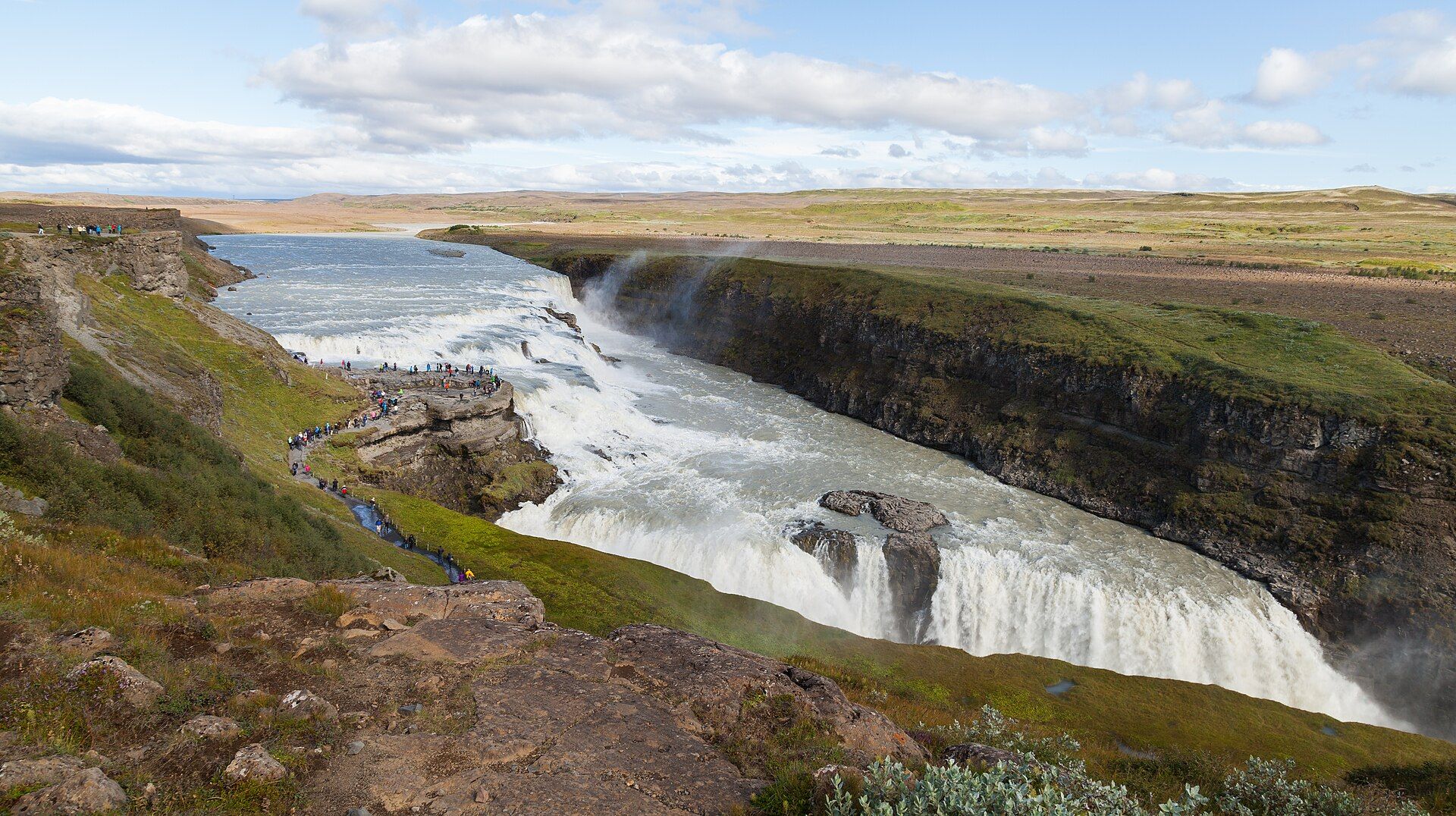
Iceland's most famous waterfall — the glacial Hvítá river plunges in two dramatic stepped tiers into a rugged canyon, throwing up spray that catches the sun in near-constant rainbows.
What makes it marvelous
Gullfoss ('golden falls') drops about 32 metres in two stages set at right angles to each other, into a crevice cut by the river through layered lava and glacial sediment. It is fed by Iceland's second-largest glacier, Langjökull, so its flow is enormous — averaging well over 100 cubic metres per second in summer — and the canyon it has carved is a lesson in the raw power of glacial meltwater.
Why visit
Standing at the lip, you feel the ground tremble and the spray on your face as the whole river disappears into the earth. In low sun the mist glows gold, and rainbows arc across the gorge. It anchors Iceland's popular 'Golden Circle' day route.
Still deciding?
Gullfoss comes up most often against these — each one weighs cost, effort, season and crowds side by side.
What to know before you go
🗓️ Best time
June to August for full flow, long daylight, and open access. Winter brings ice-framed drama but paths can be closed or hazardous; check conditions.
🧭 Getting there & access
About 1.5–2 hours' drive from Reykjavík on the Golden Circle, with a free car park, viewing platforms, and a visitor centre. No entry fee for the falls.
Good to know
- Walk both the upper and lower viewpoints — they show completely different faces of the falls.
- Wear waterproofs; the spray soaks the lower path, which can be icy.
- Pair it with Geysir and Þingvellir to complete the Golden Circle in a day.
Plan your visit
Easy🧭 Getting there
From Reykjavík, Iceland
- Drive Reykjavík → Gullfoss — roughly 1h45
- Or drive Geysir → Gullfoss — about 10 minutes
- Walk from the upper car park to the viewing platforms — 5–15 minutes
- Total travel
- Under two hours from Reykjavík
- Time at site
- An hour
- Access
- Free and open, with a visitor centre at the upper car park. The lower path that takes you along the lip of the falls is closed whenever it is icy, which is most of the winter, and the upper viewpoint is the only option then. Conditions change fast — check road status on the Icelandic road administration service before driving out in winter.
🎒 What to bring & consider
- Waterproofs rather than an umbrella, because the spray is constant and the wind will take an umbrella out of your hands
- Microspikes in winter for paths that freeze into solid ice
- A lens cloth and a plan for spray on the front element, which is the practical problem with photographing this waterfall
- A windproof layer for a canyon rim that funnels wind
- Sturdy footwear for wet, worn steps down to the lower platform when it is open
👁️ What to expect
- Crowds
- Busy midday with coach traffic. Much quieter early, late and in winter.
- Conditions
- Very wet and windy near the falls. Icy paths for much of the year.
- Facilities
- Visitor centre with café, shop and toilets at the upper car park.
- The view
- The two-stage drop into the canyon with a rainbow in the spray, which needs afternoon sun from the right angle. In winter the ice formations along the rim are the better picture, and the lower path being closed forces the wider composition anyway.
Times and requirements are approximate and change with season, weather, and local rules — confirm permits, fares, and schedules with operators before you travel.
Natural riches of the area
- Glacial meltwater from the Langjökull ice cap
- Layered basalt lava and glacial sediment carved into a canyon
- Abundant hydro and geothermal energy across the region
- Arctic river ecosystems and birdlife
Local food
- Lamb soup (kjötsúpa)
- Hearty Icelandic soup of free-ranging lamb, root vegetables, and herbs.
- Rye bread & smoked trout
- Dense geothermal-baked rúgbrauð with cured or smoked freshwater fish.
- Skyr
- Thick, protein-rich Icelandic cultured dairy, eaten sweet or plain.
Gullfoss is the showpiece of Iceland’s Golden Circle, and it earns the billing. The glacial Hvítá river, fed by the Langjökull ice cap, races across a broad shelf and then drops in two stepped tiers set at right angles, vanishing into a canyon it has spent millennia carving through lava and sediment. The volume is immense, and in summer the roar and spray are overwhelming.
The name means ‘golden falls’, for the way low Arctic sunlight turns the mist amber and paints rainbows across the gorge. There is history here too: in the early twentieth century the falls were nearly dammed for hydropower, and the campaign to save them helped seed Iceland’s conservation movement. Today they are protected — a reminder that even a country rich in water and energy chose to leave this one wild.
Gullfoss: common questions
How do you get to Gullfoss?
From Reykjavík, Iceland: Drive Reykjavík → Gullfoss — roughly 1h45; Or drive Geysir → Gullfoss — about 10 minutes; Walk from the upper car park to the viewing platforms — 5–15 minutes. Total travel time: Under two hours from Reykjavík.
When is the best time to visit Gullfoss?
June to August for full flow, long daylight, and open access. Winter brings ice-framed drama but paths can be closed or hazardous; check conditions.
How long should you spend at Gullfoss?
An hour. Total travel time: Under two hours from Reykjavík.
What should you bring to Gullfoss?
Waterproofs rather than an umbrella, because the spray is constant and the wind will take an umbrella out of your hands Microspikes in winter for paths that freeze into solid ice A lens cloth and a plan for spray on the front element, which is the practical problem with photographing this waterfall A windproof layer for a canyon rim that funnels wind Sturdy footwear for wet, worn steps down to the lower platform when it is open
Do you need a permit or guide for Gullfoss?
Free and open, with a visitor centre at the upper car park. The lower path that takes you along the lip of the falls is closed whenever it is icy, which is most of the winter, and the upper viewpoint is the only option then. Conditions change fast — check road status on the Icelandic road administration service before driving out in winter.
Is Gullfoss crowded, and what are conditions like?
Busy midday with coach traffic. Much quieter early, late and in winter. Very wet and windy near the falls. Icy paths for much of the year. Facilities: Visitor centre with café, shop and toilets at the upper car park.
Added Updated
More wonders to explore