Lake Lucerne
📍 Central Switzerland (cantons of Lucerne, Nidwalden, Obwalden, Schwyz, Uri)
A many-armed alpine lake at the heart of Switzerland — 114 square kilometres of deep blue-green water winding between the peaks of Rigi, Pilatus, and the Uri Alps, ringed by lakeside towns and the meadow where the Swiss Confederation was born.
What makes it marvelous
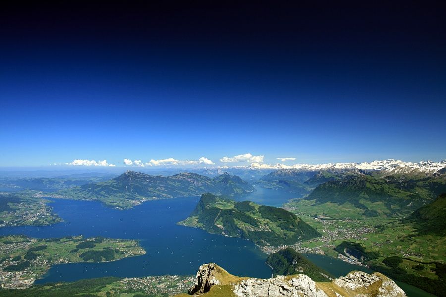
Vierwaldstättersee — the Lake of the Four Forest Cantons — is one of the most scenically complex lakes in Europe, its 114 square kilometres branching into a series of steep-walled arms and basins that reach 214 metres deep. Carved and dammed by Ice Age glaciers, it sits at 434 metres above sea level while the mountains around it rise straight from the shore to some 1,500 metres higher — Rigi and Pilatus to the north and west, the sharp Uri Alps closing in the fjord-like southern arm toward Flüelen. That southern reach, the Urnersee, is bordered by the Rütli meadow, where the founding cantons are said to have sworn the oath that began Switzerland in 1291.
Why visit
This is the classic Central Swiss lake experience — historic paddle steamers crossing between mountain villages, cogwheel railways and cable cars climbing Rigi and Pilatus straight from the water's edge, and the medieval city of Lucerne with its wooden Chapel Bridge at the lake's outlet. Few lakes pack this much scenery, history, and easy mountain access into one shoreline.
Still deciding?
Lake Lucerne comes up most often against one other place — each one weighs cost, effort, season and crowds side by side.
What to know before you go
🗓️ Best time
Best May to October, when the paddle steamers run a full timetable, the mountain railways are open, and the shoreline is green; summer is warmest for swimming, while autumn brings clear air and quieter boats.
🧭 Getting there & access
Lucerne, at the lake's northwestern tip, is about an hour by train from Zürich Airport. Historic and modern boats of the SGV fleet link Lucerne with Weggis, Vitznau, Brunnen, and Flüelen; the Rigi and Pilatus mountain railways connect directly to the lakeside piers.
Good to know
- Take a paddle steamer at least one way — the lake is best seen from the water.
- Combine a boat with the Rigi cog railway or the Pilatus cableway for a lake-and-summit day.
- The southern Urnersee arm toward Flüelen is the wildest and most dramatic stretch.
Plan your visit
Easy🧭 Getting there
From Zürich (ZRH), Switzerland
- Take the train from Zürich Airport to Lucerne (about 1h)
- Board an SGV boat or paddle steamer from the Lucerne quay
- Connect to the Rigi cog railway or Pilatus cableway from the lakeside piers
- Total travel
- Lucerne is about 1h from Zürich; a lake-and-mountain day fills 6–8h
- Time at site
- A half to full day; longer to add a summit or an overnight in a lakeside village
- Access
- Fully served by public transport year-round; the boat timetable is fullest May–October and reduced in winter. Swiss Travel Pass covers the SGV boats and many mountain lines.
🎒 What to bring & consider
- Layers — it is cooler and breezier out on the open water
- Sun protection on deck in summer
- A rail/boat timetable or the SBB app to link boats and trains
- Swimwear in summer for the lakeside lidos
👁️ What to expect
- Crowds
- Busy in summer, especially the Lucerne quays and Rigi/Pilatus; early boats are calmer.
- Conditions
- Easy, step-free lake travel; mountain excursions involve railways and cable cars.
- Facilities
- Full services in Lucerne and the lakeside towns — cafes, hotels, piers, toilets.
- The view
- The lake's arms framed by Pilatus or Rigi from the deck of a paddle steamer, best in the clear light of morning.
Times and requirements are approximate and change with season, weather, and local rules — confirm permits, fares, and schedules with operators before you travel.
Natural riches of the area
- A deep glacial lake, 214 m at its deepest, holding some 14.5 km³ of fresh water
- The surrounding peaks of Rigi, Pilatus, and the Uri Alps
- Reuss river inflow and outflow feeding and draining the lake
- Lakeside forests, meadows, and Alpine foothill habitats
Local food
- Luzerner Chügelipastete
- A Lucerne vol-au-vent — puff pastry filled with veal, mushrooms, and cream.
- Älplermagronen
- Alpine macaroni with potato, cheese, cream, and onions, served with apple sauce.
- Lake fish (perch and whitefish)
- Felchen and Egli from the lake, pan-fried and served lakeside in summer.
Lake Lucerne — Vierwaldstättersee, the Lake of the Four Forest Cantons — is the scenic heart of Switzerland. Its 114 square kilometres of deep blue-green water don’t sit in a simple basin but wind between the mountains in a series of steep-walled arms and bays, so that the view changes at every bend: the rounded green shoulder of Rigi on one side, the jagged ridge of Pilatus on the other, and to the south the lake narrows into the fjord-like Urnersee, closed in by the sharp peaks of the Uri Alps. Glaciers dug it 214 metres deep, and the slopes around it climb another 1,500 metres straight from the shore.
It is also where Switzerland began. On the shore of that southern arm lies the Rütli meadow, where the founding cantons are said to have sworn their oath in 1291. Today the lake is crossed by a fleet of historic paddle steamers that call at villages tucked beneath the peaks, and cogwheel railways and cable cars climb from the water’s edge to the summits of Rigi and Pilatus. At the northwestern tip sits the old city of Lucerne, its covered wooden Chapel Bridge spanning the Reuss where the river leaves the lake — making this one of the few places where a great lake, high mountains, and a medieval town all meet in a single view.
Lake Lucerne: common questions
How do you get to Lake Lucerne?
From Zürich (ZRH), Switzerland: Take the train from Zürich Airport to Lucerne (about 1h); Board an SGV boat or paddle steamer from the Lucerne quay; Connect to the Rigi cog railway or Pilatus cableway from the lakeside piers. Total travel time: Lucerne is about 1h from Zürich; a lake-and-mountain day fills 6–8h.
When is the best time to visit Lake Lucerne?
Best May to October, when the paddle steamers run a full timetable, the mountain railways are open, and the shoreline is green; summer is warmest for swimming, while autumn brings clear air and quieter boats.
How long should you spend at Lake Lucerne?
A half to full day; longer to add a summit or an overnight in a lakeside village. Total travel time: Lucerne is about 1h from Zürich; a lake-and-mountain day fills 6–8h.
What should you bring to Lake Lucerne?
Layers — it is cooler and breezier out on the open water Sun protection on deck in summer A rail/boat timetable or the SBB app to link boats and trains Swimwear in summer for the lakeside lidos
Do you need a permit or guide for Lake Lucerne?
Fully served by public transport year-round; the boat timetable is fullest May–October and reduced in winter. Swiss Travel Pass covers the SGV boats and many mountain lines.
Is Lake Lucerne crowded, and what are conditions like?
Busy in summer, especially the Lucerne quays and Rigi/Pilatus; early boats are calmer. Easy, step-free lake travel; mountain excursions involve railways and cable cars. Facilities: Full services in Lucerne and the lakeside towns — cafes, hotels, piers, toilets.
Added
More wonders to explore