Lake Mývatn
📍 Northeast Iceland, near Akureyri
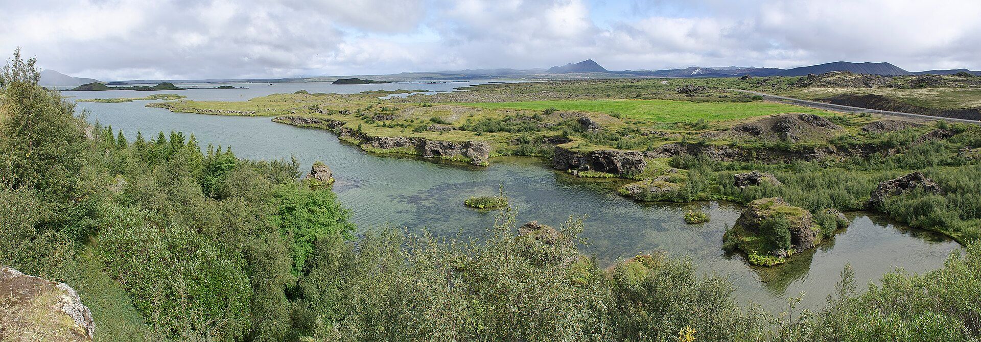
A shallow, volcanic lake ringed by craters, lava fields and steaming ground — one of Europe's richest waterfowl habitats, alive with ducks in summer and framed by pseudocraters, twisted lava pillars and geothermal steam.
What makes it marvelous
Mývatn sits in one of Iceland's most active volcanic zones, and everything around it is a product of fire and water. Rootless 'pseudocraters' pock its shores, formed when lava flowed over wet ground and flashed it to steam; the black lava labyrinth of Dimmuborgir, the ash cone of Hverfjall, and the boiling mud and fumaroles of Námaskarð all lie within reach. The lake is shallow and unusually productive, and its clouds of midges — which give it its name — feed one of the densest concentrations of breeding ducks anywhere.
Why visit
Few lakes pack this much geology and life into one basin. In a single day you can walk lava pillars, climb a crater rim, watch ducks by the thousand, and soak in geothermal baths — the quieter northern answer to the Blue Lagoon.
Still deciding?
Lake Mývatn comes up most often against these — each one weighs cost, effort, season and crowds side by side.
More views of Lake Mývatn
Additional photographs of the actual site — each freely licensed, with its photographer and licence credited.
What to know before you go
🗓️ Best time
June to August for birdlife, ice-free water, open roads and long daylight — though this is also peak midge season; late spring and early autumn are quieter with fewer insects.
🧭 Getting there & access
On the Ring Road in the northeast, about an hour east of Akureyri. A road loops the lake, linking the pseudocraters, Dimmuborgir, Hverfjall and the nature baths.
Good to know
- Carry a fine head net in summer — the midges are harmless but relentless around the water.
- Do the Dimmuborgir lava trails and the Hverfjall crater rim on the same loop.
- End at the Mývatn Nature Baths, the north's geothermal spa, to soak off the day.
Plan your visit
Easy🧭 Getting there
From Akureyri (AEY), Iceland
- Fly to Akureyri or drive the Ring Road across the north
- Continue about an hour east to the Mývatn area
- A loop road links the lake's craters, lava fields and baths
- Total travel
- About 1h from Akureyri
- Time at site
- A full day to circle the lake and its sites; two if adding Krafla and Dettifoss
- Access
- Open access to the lake and most sites; some, like Dimmuborgir and the nature baths, have their own hours or entry. Roads are generally open year-round here but winter driving needs care and current road-status checks.
🎒 What to bring & consider
- A midge head net and light long sleeves for summer near the water
- Sturdy shoes for lava trails and the loose Hverfjall crater rim
- Layers and wind protection; the north is cool and changeable
- Swimwear for the geothermal baths
👁️ What to expect
- Crowds
- Steady summer traffic at Dimmuborgir and the baths; the lakeshore stays calm.
- Conditions
- Mostly easy walking; the crater rim is a short steep climb on scree.
- Facilities
- Villages, cafes, fuel and the nature baths around the lake.
- The view
- The pseudocraters at Skútustaðir mirrored in still water at dawn, before the wind and the day's traffic arrive.
Times and requirements are approximate and change with season, weather, and local rules — confirm permits, fares, and schedules with operators before you travel.
Natural riches of the area
- A shallow, biologically rich volcanic lake
- Pseudocraters, lava fields and the Hverfjall ash cone
- Geothermal fields with mud pots and fumaroles (Námaskarð)
- Internationally important breeding grounds for ducks and waterfowl
Local food
- Geothermal rye bread (hverabrauð)
- Dense, dark, slightly sweet bread baked slowly in the hot ground around the lake.
- Arctic char
- Cold-water fish from the lake and northern rivers, often smoked.
- Smoked lamb (hangikjöt)
- Traditionally smoked using sheep dung and birch, a northern specialty.
Mývatn is less a lake than a whole volcanic landscape gathered around water. It lies in one of Iceland’s most active zones, and its shores record the encounters of lava with wet ground: rings of rootless pseudocraters, thrown up when molten rock boiled the marsh beneath it; the black lava pillars of Dimmuborgir; the clean ash cone of Hverfjall; and, just over a ridge, the mud pots and sulphur-yellow fumaroles of Námaskarð. It is a place to read the island’s geology at walking pace.
The lake itself is shallow and extraordinarily alive. Its name means ‘midge lake’, and those summer clouds of insects, harmless if maddening, underpin a food web that supports one of the richest gatherings of breeding ducks in the world. Add the geothermal Mývatn Nature Baths — the north’s quieter counterpart to the Blue Lagoon — and a single unhurried day can take in craters, lava, birdlife and a long hot soak.
Lake Mývatn: common questions
How do you get to Lake Mývatn?
From Akureyri (AEY), Iceland: Fly to Akureyri or drive the Ring Road across the north; Continue about an hour east to the Mývatn area; A loop road links the lake's craters, lava fields and baths. Total travel time: About 1h from Akureyri.
When is the best time to visit Lake Mývatn?
June to August for birdlife, ice-free water, open roads and long daylight — though this is also peak midge season; late spring and early autumn are quieter with fewer insects.
How long should you spend at Lake Mývatn?
A full day to circle the lake and its sites; two if adding Krafla and Dettifoss. Total travel time: About 1h from Akureyri.
What should you bring to Lake Mývatn?
A midge head net and light long sleeves for summer near the water Sturdy shoes for lava trails and the loose Hverfjall crater rim Layers and wind protection; the north is cool and changeable Swimwear for the geothermal baths
Do you need a permit or guide for Lake Mývatn?
Open access to the lake and most sites; some, like Dimmuborgir and the nature baths, have their own hours or entry. Roads are generally open year-round here but winter driving needs care and current road-status checks.
Is Lake Mývatn crowded, and what are conditions like?
Steady summer traffic at Dimmuborgir and the baths; the lakeshore stays calm. Mostly easy walking; the crater rim is a short steep climb on scree. Facilities: Villages, cafes, fuel and the nature baths around the lake.
Added
More wonders to explore