Franz Josef Glacier
📍 Westland Tai Poutini National Park, South Island, New Zealand
A steep river of blue ice that pours from the Southern Alps almost into rainforest — one of only a handful of glaciers on Earth that descend so close to temperate forest and the sea, and one of the fastest-moving, tumbling from high snowfields to a valley of ferns.
What makes it marvelous
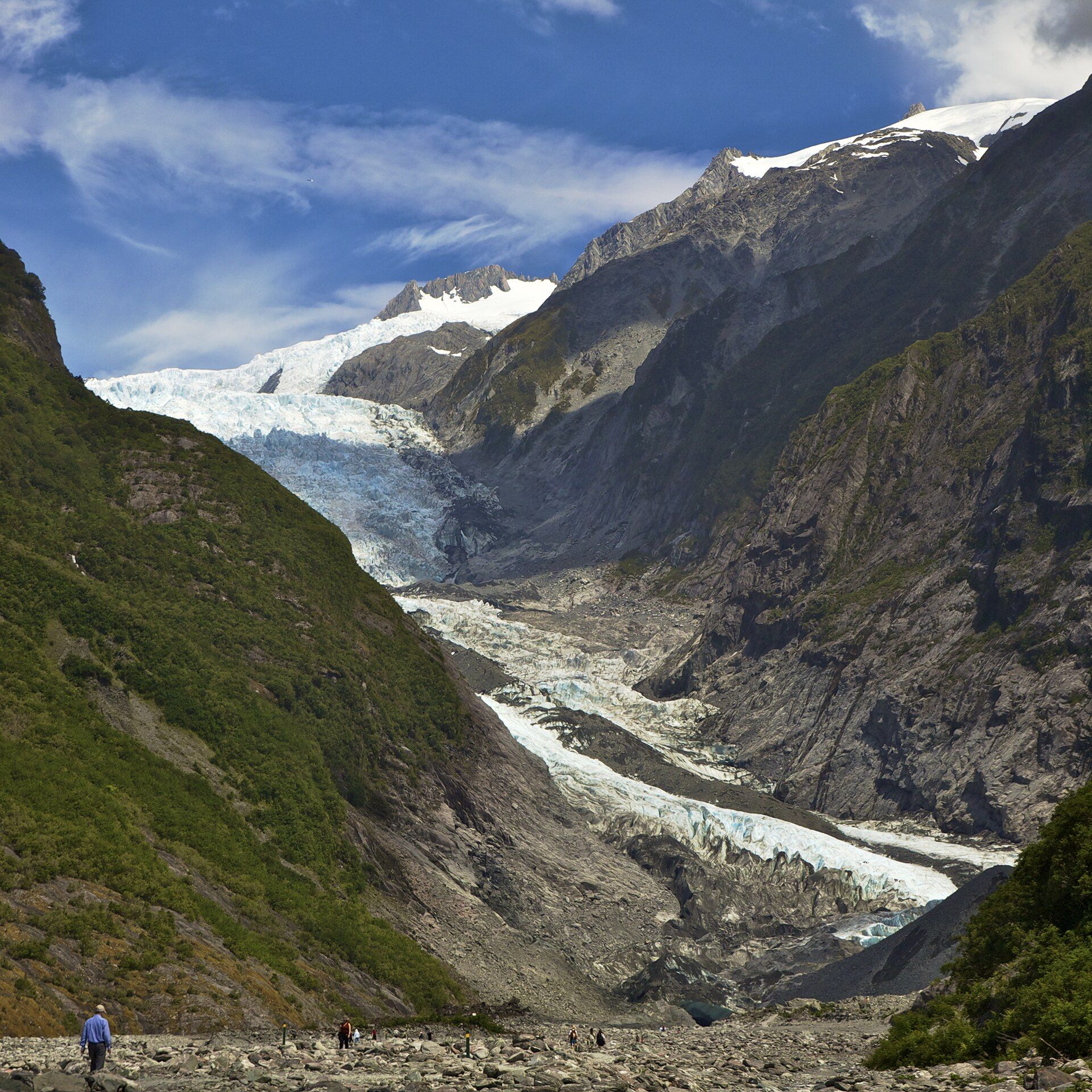
Franz Josef Glacier (Kā Roimata o Hine Hukatere) drops about 12 kilometres from the snowfields of the Southern Alps down a steep valley on the wet West Coast of the South Island. What makes it remarkable is where it ends: it is one of very few glaciers in the world that flow down almost to a temperate rainforest zone, its terminal face among the lowest of any such glacier on Earth, so that ferns and podocarp forest grow within sight of the ice. The steepness of its valley makes it one of the fastest-moving glaciers anywhere, advancing several metres a day at its icefall, its surface a chaos of blue seracs and crevasses. Fed by some of the heaviest snowfall in the Alps, it has advanced and retreated dramatically over the past century, and today sits well back up its valley — a shifting, living river of ice framed by rainforest and cloud.
Why visit
Franz Josef lets you stand near a great glacier that ends among ferns and rainforest — a rare, fast-moving river of blue ice set against green West Coast forest. Guided ice walks and helicopter landings reach the upper glacier, while valley trails give views from below.
Still deciding?
Franz Josef Glacier comes up most often against these — each one weighs cost, effort, season and crowds side by side.
What to know before you go
🗓️ Best time
Year-round; the West Coast is wet in every season, so pick settled weather for clear views. Guided ice and heli trips run whenever conditions allow — summer (December–February) offers the longest, warmest days.
🧭 Getting there & access
From Franz Josef township on State Highway 6 on the West Coast. A valley walk leads toward a viewpoint of the terminal face; access onto the ice itself is by guided helicopter tour only, as the lower glacier is no longer safely reachable on foot.
Good to know
- Check the forecast and go on a clear window — low cloud and rain often hide the ice.
- To walk on the glacier you must take a licensed heli-hike; the valley-floor trail is a viewpoint only.
- Combine it with nearby Fox Glacier and the mirror reflections of Lake Matheson.
Plan your visit
Moderate🧭 Getting there
From Franz Josef township (via Hokitika or Queenstown), West Coast
- Drive State Highway 6 up the West Coast to Franz Josef township
- For a ground view, walk the valley trail toward the terminal-face viewpoint
- To reach the ice, book a licensed helicopter ice-hike from the township
- Total travel
- A half to full day; longer to combine with Fox Glacier and Lake Matheson
- Time at site
- A couple of hours for the valley walk; a heli-hike is a half-day
- Access
- The valley trail is open access to a viewpoint; the glacier surface can only be reached by guided helicopter tours, since retreat has made the lower ice unsafe to approach on foot. Trips are weather-dependent and can be cancelled at short notice — glacier conditions and access change over time, so check with local operators and the Department of Conservation.
🎒 What to bring & consider
- Full waterproofs and warm layers — the West Coast is very wet and the ice is cold
- Sturdy footwear for the valley track; guided trips supply glacier boots and crampons
- Flexibility in your schedule, as heli-hikes are often delayed or cancelled by weather
- Sandfly repellent for the valley and forest
👁️ What to expect
- Crowds
- The township and valley walk can be busy in summer; the guided ice is limited by helicopter capacity and weather.
- Conditions
- An easy valley walk to the viewpoint; the guided ice-hike involves crampons and uneven glacier travel.
- Facilities
- Franz Josef township has hotels, cafes, hot pools, and tour operators; the valley and glacier have none.
- The view
- The blue icefall spilling down its valley with rainforest below, or a clear-morning view of the terminal face from the valley trail.
Times and requirements are approximate and change with season, weather, and local rules — confirm permits, fares, and schedules with operators before you travel.
Natural riches of the area
- A steep, fast-moving glacier fed by heavy alpine snowfall
- One of the world's lowest-descending glaciers into temperate rainforest
- Blue seracs, icefalls, and crevasses on the upper glacier
- West Coast rainforest of ferns and podocarp around the valley
Local food
- West Coast whitebait
- A prized seasonal delicacy of the coast, fried into fritters when the run is on.
- Venison
- New Zealand farm-raised venison features on West Coast menus.
- Manuka honey
- Produced across New Zealand from the manuka bush, sold throughout the region.
Franz Josef Glacier is a collision of climates. It pours about 12 kilometres down a steep valley from the snowfields of the Southern Alps, and instead of ending in bare rock or tundra it descends almost to a temperate rainforest — one of the very few glaciers on Earth to do so, with ferns and podocarp forest growing within sight of the ice. Fed by some of the heaviest snowfall in New Zealand and squeezed down a steep bed, it is also one of the fastest-moving glaciers in the world, its icefall creeping several metres a day and its surface a broken maze of blue seracs and crevasses.
That speed makes it a living, shifting thing. Over the past century Franz Josef has surged forward and drawn sharply back, and today it sits well up its valley, its lower reaches too unstable to walk to — the ice is now reached by helicopter, landing hikers on the blue upper glacier above the forest. From the valley floor a trail leads to a viewpoint of the terminal face, framed by cloud and green West Coast bush. Wild, wet, and restless, it is a river of ice in a land of ferns.
Franz Josef Glacier: common questions
How do you get to Franz Josef Glacier?
From Franz Josef township (via Hokitika or Queenstown), West Coast: Drive State Highway 6 up the West Coast to Franz Josef township; For a ground view, walk the valley trail toward the terminal-face viewpoint; To reach the ice, book a licensed helicopter ice-hike from the township. Total travel time: A half to full day; longer to combine with Fox Glacier and Lake Matheson.
When is the best time to visit Franz Josef Glacier?
Year-round; the West Coast is wet in every season, so pick settled weather for clear views. Guided ice and heli trips run whenever conditions allow — summer (December–February) offers the longest, warmest days.
How long should you spend at Franz Josef Glacier?
A couple of hours for the valley walk; a heli-hike is a half-day. Total travel time: A half to full day; longer to combine with Fox Glacier and Lake Matheson.
What should you bring to Franz Josef Glacier?
Full waterproofs and warm layers — the West Coast is very wet and the ice is cold Sturdy footwear for the valley track; guided trips supply glacier boots and crampons Flexibility in your schedule, as heli-hikes are often delayed or cancelled by weather Sandfly repellent for the valley and forest
Do you need a permit or guide for Franz Josef Glacier?
The valley trail is open access to a viewpoint; the glacier surface can only be reached by guided helicopter tours, since retreat has made the lower ice unsafe to approach on foot. Trips are weather-dependent and can be cancelled at short notice — glacier conditions and access change over time, so check with local operators and the Department of Conservation.
Is Franz Josef Glacier crowded, and what are conditions like?
The township and valley walk can be busy in summer; the guided ice is limited by helicopter capacity and weather. An easy valley walk to the viewpoint; the guided ice-hike involves crampons and uneven glacier travel. Facilities: Franz Josef township has hotels, cafes, hot pools, and tour operators; the valley and glacier have none.
Added
More wonders to explore