Triglav National Park
📍 Julian Alps, north-western Slovenia, on the border with Italy and close to Austria
Slovenia's only national park: 840 km² of the eastern Julian Alps around Triglav (2,864 m), the country's highest peak, with Lake Bohinj, the Savica waterfall, glacier-carved valleys and high karst plateaus. Protected since 1924.
What makes it marvelous
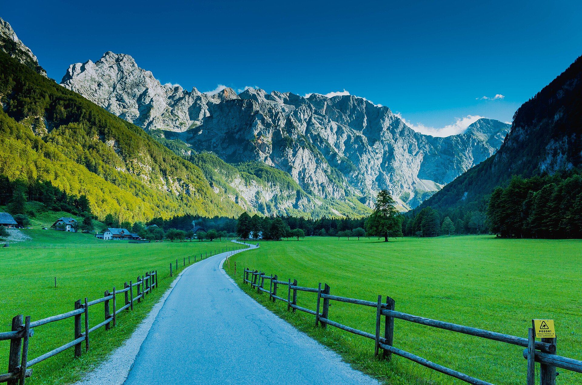
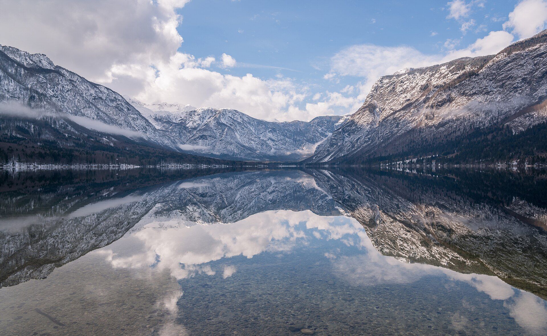
Triglav National Park covers 840 km² — about four percent of Slovenia — and overlaps almost completely with the eastern Julian Alps. At its heart rises Triglav, at 2,864 m the highest peak in Slovenia; the park's lowest point, the Tolminska korita gorges, lies at just 180 m. Its grey limestone was laid down in ancient seas over more than 200 million years, pushed up by the collision of the African and Eurasian plates, and then shaped by glaciers and water into sharp ridges, high karst plateaus, wide U-shaped valleys, hanging side valleys and deep gorges. In a glacial basin on the park's southern side lies Lake Bohinj, the largest permanent natural lake in Slovenia, holding almost 100 million cubic metres of water. Its main feeder, the Savica, emerges from cave passages fed by the Triglav Lakes Valley and drops 78 m as the Savica waterfall.
Why visit
Hike from the shore of Lake Bohinj into limestone high country, climb to the Savica waterfall or follow glacier-cut valleys toward Triglav itself — one of the oldest protected mountain landscapes in Europe, and Slovenia's only national park.
Still deciding?
Triglav National Park comes up most often against one other place — each one weighs cost, effort, season and crowds side by side.
What to know before you go
🗓️ Best time
Summer and early autumn, roughly June to September, for mountain hiking, when the high trails are mostly clear of snow; even then the park warns of rapid weather changes and storms, with snowfields lingering high up. Spring and autumn bring the strongest flow at the Savica waterfall, and Lake Bohinj warms to about 24 °C at the surface in summer.
🧭 Getting there & access
The main valley gateways are Bohinj, Bled, Kranjska Gora, Bovec and Tolmin. Summer bus services link Bled, Bohinj, Kranjska Gora and the Soča Valley, and a car-train runs through the mountains from Bohinjska Bistrica toward Nova Gorica. Triglav itself is a demanding high-mountain climb; the park advises hiring a guide if you are not familiar with the terrain.
Good to know
- The Julian Alps are demanding: the park advises matching routes to your fitness and experience, checking the mountain weather forecast, and leaving word of where you are going.
- Swimming and other recreation are prohibited in the high mountain lakes inside the park's first protection zone — swim in Lake Bohinj instead.
- Flying drones is restricted throughout the park and needs prior consent from the park authority.
- The trail to the Savica waterfall climbs 553 stone steps from the car park by the Savica hut — about 20 to 25 minutes, and not suitable for prams or wheelchairs.
Plan your visit
Strenuous🧭 Getting there
From Ljubljana (LJU), Slovenia
- Fly into Ljubljana
- Drive or take the bus to Bled, then on to Bohinj — roughly 1–1.5 hours from Ljubljana to Lake Bohinj depending on traffic
- In summer, use the park-area bus services between Bled, Bohinj, Kranjska Gora and the Soča Valley
- Total travel
- Roughly 1–1.5 hours by road from Ljubljana to Lake Bohinj
- Time at site
- A day for Lake Bohinj and the Savica waterfall; two or three days to climb Triglav with mountain-hut nights
- Access
- Individual sites such as the Savica waterfall have their own opening hours and visitor information, so confirm current conditions with the park (tnp.si) before you go. Swimming and other recreation are banned on the high mountain lakes in the first protection zone, mushroom picking is banned in the first and second zones, and mountain biking is allowed only on designated roads and routes. Drones need prior consent from the park authority. High routes, including Triglav, need proper mountain equipment and experience — hire a mountain guide if you are not sure.
🎒 What to bring & consider
- Sturdy, high mountain boots with good grip
- Warm layers, waterproofs and gloves, since storms and cold fronts can arrive fast even in summer
- A map and compass or offline map, and the mountain weather forecast checked before setting out
- A first-aid kit and enough food and drink for the day
- For Triglav itself, a mountain guide unless you are experienced on exposed high-alpine routes
👁️ What to expect
- Crowds
- Lake Bohinj and the Savica waterfall are busy on summer days; the high trails toward Triglav are popular at weekends and in July and August.
- Conditions
- Everything from flat lakeside walks to exposed high-alpine terrain with scree, snowfields and rapid weather changes.
- Facilities
- Villages around the edge of the park with lodging and park information points; mountain huts on the main high routes.
- The view
- Lake Bohinj in still morning light with the limestone walls of the Julian Alps rising behind.
Times and requirements are approximate and change with season, weather, and local rules — confirm permits, fares, and schedules with operators before you travel.
Natural riches of the area
- Triglav (2,864 m), Slovenia's highest peak
- Lake Bohinj, the largest permanent natural lake in Slovenia
- The Savica waterfall, a 78-m twin cascade fed from underground
- High karst plateaus, glacier-carved valleys and gorges in the eastern Julian Alps
Local food
- Mohant
- A strong, soft cheese from the Bohinj valley, one of Slovenia's protected local cheeses.
- Tolminc
- A hard mountain cheese from the Tolmin area on the park's south-western side.
Triglav National Park is Slovenia’s only national park. It covers 840 square kilometres of the eastern Julian Alps in the north-west of the country, on the border with Italy and close to Austria. It takes its name from Triglav, which at 2,864 metres is the highest peak in Slovenia. Protection here began in 1924, when an Alpine Conservation Park was created in the valley of the Triglav Lakes. The park took its present form under the Triglav National Park Act of 1981.
The mountains are limestone, laid down layer by layer in ancient seas over more than 200 million years. The collision of the African and Eurasian plates later pushed that rock into the Alps. Glaciers and water then carved it into sharp ridges, high karst plateaus, broad U-shaped valleys and deep gorges. Small side valleys left hanging above the main ones now pour over their edges as waterfalls. High up, the karst is almost dry: rainwater sinks through cracks into a maze of shafts and caves.
On the southern side, Lake Bohinj fills a glacial basin. It is the largest permanent natural lake in Slovenia, holding almost 100 million cubic metres of water, and in summer the surface warms to about 24 °C. Its main feeder, the Savica, flows underground from the Triglav Lakes Valley and comes out of the cliff as the Savica waterfall, a 78-metre drop in two streams that you reach by 553 stone steps. Come between June and September for the high trails. Even then, be ready for sudden storms, and remember that swimming is not allowed in the high mountain lakes.
Triglav National Park: common questions
How do you get to Triglav National Park?
From Ljubljana (LJU), Slovenia: Fly into Ljubljana; Drive or take the bus to Bled, then on to Bohinj — roughly 1–1.5 hours from Ljubljana to Lake Bohinj depending on traffic; In summer, use the park-area bus services between Bled, Bohinj, Kranjska Gora and the Soča Valley. Total travel time: Roughly 1–1.5 hours by road from Ljubljana to Lake Bohinj.
When is the best time to visit Triglav National Park?
Summer and early autumn, roughly June to September, for mountain hiking, when the high trails are mostly clear of snow; even then the park warns of rapid weather changes and storms, with snowfields lingering high up. Spring and autumn bring the strongest flow at the Savica waterfall, and Lake Bohinj warms to about 24 °C at the surface in summer.
How long should you spend at Triglav National Park?
A day for Lake Bohinj and the Savica waterfall; two or three days to climb Triglav with mountain-hut nights. Total travel time: Roughly 1–1.5 hours by road from Ljubljana to Lake Bohinj.
What should you bring to Triglav National Park?
Sturdy, high mountain boots with good grip Warm layers, waterproofs and gloves, since storms and cold fronts can arrive fast even in summer A map and compass or offline map, and the mountain weather forecast checked before setting out A first-aid kit and enough food and drink for the day For Triglav itself, a mountain guide unless you are experienced on exposed high-alpine routes
Do you need a permit or guide for Triglav National Park?
Individual sites such as the Savica waterfall have their own opening hours and visitor information, so confirm current conditions with the park (tnp.si) before you go. Swimming and other recreation are banned on the high mountain lakes in the first protection zone, mushroom picking is banned in the first and second zones, and mountain biking is allowed only on designated roads and routes. Drones need prior consent from the park authority. High routes, including Triglav, need proper mountain equipment and experience — hire a mountain guide if you are not sure.
Is Triglav National Park crowded, and what are conditions like?
Lake Bohinj and the Savica waterfall are busy on summer days; the high trails toward Triglav are popular at weekends and in July and August. Everything from flat lakeside walks to exposed high-alpine terrain with scree, snowfields and rapid weather changes. Facilities: Villages around the edge of the park with lodging and park information points; mountain huts on the main high routes.
Added