Logar Valley
📍 Solčava, Upper Savinja Valley, northern Slovenia, beneath the Kamnik-Savinja Alps
A glacier-carved alpine valley 7 km long in Slovenia's Kamnik-Savinja Alps, ringed by limestone peaks over 2,000 m and closed by the 90-m Rinka waterfall — a landscape park since 1987, with 43 recorded natural features.
What makes it marvelous
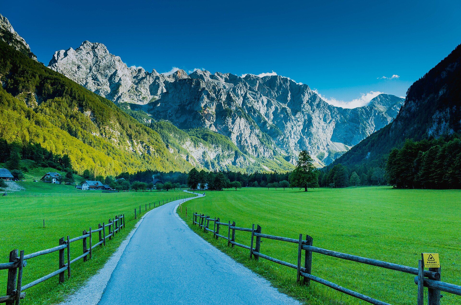
The Logar Valley (Logarska dolina) was shaped by a glacier in the last Ice Age, deep in the Kamnik-Savinja Alps. It runs about 7 km with an average width of only 250 m, walled in by peaks over 2,000 m high — Ojstrica, Planjava, Brana, Turska gora, Krofička and the Rinke. Its lower parts, Log and Plest, are open grassy meadows; the upper end, Kot, is mostly forest. At the head of the valley the Rinka waterfall, one of the highest free-falling waterfalls in Slovenia, drops 90 m in an arc into a rock amphitheatre before vanishing into the gravel below Okrešelj; it was declared a natural monument in 1987. Around 100 waterfalls are found in the wider Solčava area, among them the 78-m Palenk fall and the four Brložnica falls, which together drop 125 m. The valley was declared a landscape park in 1987 for its 43 natural features and the farm landscape that has grown up alongside them.
Why visit
Walk or cycle up a flat, meadow-floored valley between sheer limestone walls to the Rinka waterfall — a quiet, farm-dotted corner of the Alps that feels far from the crowds.
Still deciding?
Logar Valley comes up most often against one other place — each one weighs cost, effort, season and crowds side by side.
What to know before you go
🗓️ Best time
Late spring to early autumn for hiking, cycling and the waterfalls, which are at their most impressive after rain; the vehicle entry fee is collected from April. In winter the valley's frozen falls draw ice climbers, and there is cross-country skiing and ski touring.
🧭 Getting there & access
From Ljubljana, Celje or Maribor take the A1 motorway to the Logarska dolina exit, then road 225 past Mozirje and road 428 to the valley. From Kamnik you can come over Črnivec and Luče, and from Austria via the Pavlič pass. Infrequent buses run from Celje to Logarska dolina and Solčava.
Good to know
- Entry is free on foot or by bike; a fee is charged for motor vehicles, and it lets you park in designated spots along the valley.
- Allow about two hours one way for the full Logar Valley Trail to the Rinka waterfall — you can join it at several points.
- Staying overnight in the Solčava municipality? Your accommodation's confirmation means you pay the vehicle fee only once for the whole stay.
- A short section of the trail at the Dom planincev mountain hut is wheelchair accessible.
Plan your visit
Easy🧭 Getting there
From Ljubljana (LJU), Slovenia
- Fly into Ljubljana
- Drive the A1 motorway east to the Logarska dolina exit
- Follow road 225 past Mozirje, then road 428 up the Upper Savinja Valley to Logarska dolina — roughly 1.5–2 hours from Ljubljana depending on traffic and stops
- Total travel
- Roughly 1.5–2 hours by road from Ljubljana
- Time at site
- A full day for the valley trail and Rinka waterfall; longer for hikes into the surrounding peaks
- Access
- Walkers and cyclists enter the landscape park free; motor vehicles pay an entrance fee at the valley, collected on a seasonal timetable from April. Confirm current fees and collection times with the Logar Valley Landscape Park (logarska-dolina.si) before you go. Several mountain huts open seasonally for hikes up toward Okrešelj and the peaks.
🎒 What to bring & consider
- Walking shoes for the valley trail, or mountain boots for the climbs above
- A rain layer — the waterfalls are best after rain, and weather in the Alps changes quickly
- Cash or card for the vehicle entrance fee if you drive in
- A packed lunch, or time to stop at one of the tourist farms
👁️ What to expect
- Crowds
- Busiest on summer weekends; weekdays and the upper Kot end of the valley are quieter.
- Conditions
- A gentle, mostly flat valley floor, with a short climb to the Rinka waterfall viewpoint and steep mountain trails beyond.
- Facilities
- Hotels, tourist farms, mountain huts and food providers in and around the valley; an information point in the valley and the Rinka centre in Solčava.
- The view
- The Rinka waterfall arcing 90 m into its rock amphitheatre, seen from below the Eagle's Nest lookout.
Times and requirements are approximate and change with season, weather, and local rules — confirm permits, fares, and schedules with operators before you travel.
Natural riches of the area
- A glacier-carved valley about 7 km long and 250 m wide
- The Rinka waterfall, a 90-m free fall and natural monument
- Limestone peaks over 2,000 m of the Kamnik-Savinja Alps
- Some 100 waterfalls in the wider Solčava area
Local food
- Zgornjesavinjski želodec
- Upper Savinja pork stomach — geographically protected dried pork and bacon, matured on wooden boards for four to five months and served thinly sliced.
- Solčavski sirnek
- A matured, lightly salted curd cheese with cumin, finished with fresh cream; the base of the local sirnica 'soup'.
- Ajdnek
- Buckwheat dough with walnuts and honey, one of the valley's traditional dishes.
The Logar Valley, or Logarska dolina, cuts north into Slovenia’s Kamnik-Savinja Alps. A glacier carved it in the last Ice Age. The valley is about seven kilometres long but on average only 250 metres wide, and limestone peaks over 2,000 metres high close in on three sides: Ojstrica, Planjava, Brana, Turska gora, Krofička and the Rinke. Log and Plest, the lower parts, are open grassy meadows dotted with farms. The upper end, Kot, is mostly forest.
At the head of the valley the Rinka waterfall drops 90 metres in a single arc into a rock amphitheatre. It is one of the highest free-falling waterfalls in Slovenia, and below it the water disappears into the gravel under Okrešelj. The wider Solčava area has around a hundred waterfalls. They include the Palenk fall, which drops 78 metres over a shattered cliff above the valley floor, and the Brložnica falls, four separate drops that together fall 125 metres.
The valley was declared a landscape park in 1987 for its 43 natural features and for the farm landscape that has grown up alongside them over centuries. The Logar Valley Trail runs up the valley past the second source of the Savinja river and huge boulders to the Rinka waterfall, about two hours one way. Entry is free on foot or by bike, and drivers pay a vehicle fee. In winter the frozen falls become ice-climbing routes.
Logar Valley: common questions
How do you get to Logar Valley?
From Ljubljana (LJU), Slovenia: Fly into Ljubljana; Drive the A1 motorway east to the Logarska dolina exit; Follow road 225 past Mozirje, then road 428 up the Upper Savinja Valley to Logarska dolina — roughly 1.5–2 hours from Ljubljana depending on traffic and stops. Total travel time: Roughly 1.5–2 hours by road from Ljubljana.
When is the best time to visit Logar Valley?
Late spring to early autumn for hiking, cycling and the waterfalls, which are at their most impressive after rain; the vehicle entry fee is collected from April. In winter the valley's frozen falls draw ice climbers, and there is cross-country skiing and ski touring.
How long should you spend at Logar Valley?
A full day for the valley trail and Rinka waterfall; longer for hikes into the surrounding peaks. Total travel time: Roughly 1.5–2 hours by road from Ljubljana.
What should you bring to Logar Valley?
Walking shoes for the valley trail, or mountain boots for the climbs above A rain layer — the waterfalls are best after rain, and weather in the Alps changes quickly Cash or card for the vehicle entrance fee if you drive in A packed lunch, or time to stop at one of the tourist farms
Do you need a permit or guide for Logar Valley?
Walkers and cyclists enter the landscape park free; motor vehicles pay an entrance fee at the valley, collected on a seasonal timetable from April. Confirm current fees and collection times with the Logar Valley Landscape Park (logarska-dolina.si) before you go. Several mountain huts open seasonally for hikes up toward Okrešelj and the peaks.
Is Logar Valley crowded, and what are conditions like?
Busiest on summer weekends; weekdays and the upper Kot end of the valley are quieter. A gentle, mostly flat valley floor, with a short climb to the Rinka waterfall viewpoint and steep mountain trails beyond. Facilities: Hotels, tourist farms, mountain huts and food providers in and around the valley; an information point in the valley and the Rinka centre in Solčava.
Added
More wonders to explore