The Dolomites
📍 South Tyrol / Trentino / Veneto, Northern Italy
A range of pale limestone towers, sheer walls, and jagged spires in the Italian Alps that glow rose and gold at dawn and dusk — the famous 'enrosadira' — above green alpine meadows and turquoise lakes.
What makes it marvelous
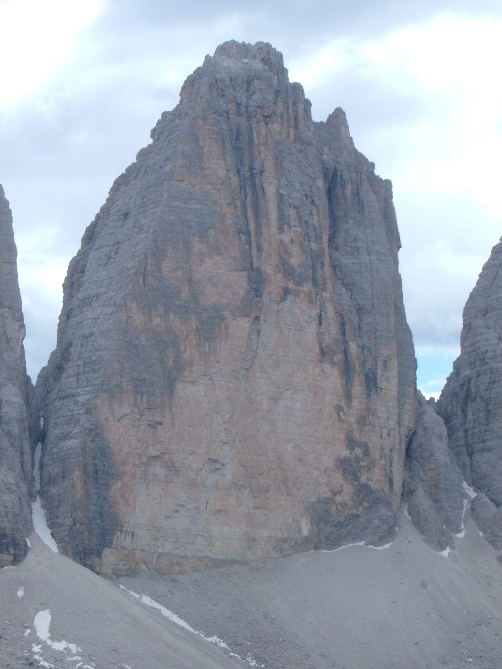
The Dolomites are built from ancient coral reefs and lagoon sediments, laid down in a tropical sea over 200 million years ago, then lifted and eroded into vertical cliffs and needle-like peaks. The rock — dolomite — reflects warm light so strongly that the mountains blush pink and orange at sunrise and sunset, a phenomenon locals call enrosadira. Eighteen peaks top 3,000 metres.
Why visit
Few mountain landscapes are so photogenic: pale spires over emerald meadows, mirror lakes like Braies and Sorapis, and a network of trails and via ferrata (cabled climbing routes) pioneered in these very mountains. It's a paradise for hikers in summer and skiers in winter.
What to know before you go
🗓️ Best time
June to September for hiking, open mountain huts, and wildflower meadows; December to March for skiing. Late spring and autumn are quieter and beautiful.
🧭 Getting there & access
Reached from Bolzano, Cortina d'Ampezzo, or Venice/Verona airports, then mountain roads and cable cars. A dense network of rifugi (mountain huts) supports multi-day treks.
Good to know
- Start hikes early to catch the enrosadira glow and beat afternoon storms.
- Book rifugi ahead in summer for hut-to-hut treks.
- Try a via ferrata only with proper kit and, if inexperienced, a guide.
Plan your visit
Moderate🧭 Getting there
From Venice (VCE), Verona (VRN) or Innsbruck (INN)
- Fly to Venice
- Road Venice → Cortina d'Ampezzo — roughly 2h–2h30
- Bolzano and the Val Gardena side — about 3h from Venice, then local buses and cable cars from the valley towns
- Total travel
- Half a day from Venice
- Time at site
- 3–5 days minimum; a week if you want to move between valleys
- Access
- Trails are open access. Rifugi must be booked ahead in summer and close outside their season. Via ferrata routes need a proper harness kit and the competence to use it. Several high passes close in winter, and some scenic roads and lake approaches now run seasonal access or booking systems — check before driving.
🎒 What to bring & consider
- Layers and a windproof — weather at 2,500m turns fast and afternoon thunderstorms are routine through summer
- Boots with ankle support; much of the walking is on loose scree
- A proper via ferrata set and helmet if you attempt one, hired locally rather than improvised
- Cash for the huts, several of which still take no cards
- An offline map — the valleys drop signal completely
👁️ What to expect
- Crowds
- The famous lakes and the Tre Cime loop are busy from mid-morning. The trail network is large enough that you can walk away from it in an hour.
- Conditions
- Steep, rocky and high. Cable cars shorten a great deal of it, but they run only in season.
- Facilities
- Excellent — rifugi serve real meals and beds right across the range, and the valley towns are well equipped.
- The view
- Alpenglow on the pale limestone at dawn and dusk is what people come for. Summer afternoons cloud over reliably, so go early.
Times and requirements are approximate and change with season, weather, and local rules — confirm permits, fares, and schedules with operators before you travel.
Natural riches of the area
- Fossil-rich dolomite limestone (ancient reef rock)
- Alpine meadows, larch and spruce forest, and glacial lakes
- Chamois, ibex, marmots, and golden eagles
- Mountain pasture supporting dairy and cheese-making
Local food
- Canederli (knödel)
- Tyrolean bread dumplings with speck or cheese — the Alps meet Italy.
- Speck & mountain cheese
- Juniper-smoked cured ham and alpine cheeses from South Tyrol's high pastures.
- Apple strudel
- From the orchards of the Adige valley below the peaks.
The Dolomites don’t look quite like other mountains, and there’s a reason: they are made of the bones of an ancient sea. Over 200 million years ago this was a warm, shallow ocean of coral reefs and lagoons; the compacted sediment became dolomite rock, later thrust skyward and carved by ice and weather into the sheer walls and needle-like spires you see today. Fossils of that vanished sea are still embedded in the cliffs.
Their most famous trick is a trick of light. At dawn and dusk the pale rock catches the low sun and blushes pink, orange, and rose — the enrosadira — before fading to grey. Below the peaks lie emerald meadows and turquoise lakes, threaded by a legendary network of trails, mountain huts, and via ferrata. It is one of the most beautiful and beloved mountain landscapes in Europe.
The Dolomites: common questions
How do you get to The Dolomites?
From Venice (VCE), Verona (VRN) or Innsbruck (INN): Fly to Venice; Road Venice → Cortina d'Ampezzo — roughly 2h–2h30; Bolzano and the Val Gardena side — about 3h from Venice, then local buses and cable cars from the valley towns. Total travel time: Half a day from Venice.
When is the best time to visit The Dolomites?
June to September for hiking, open mountain huts, and wildflower meadows; December to March for skiing. Late spring and autumn are quieter and beautiful.
How long should you spend at The Dolomites?
3–5 days minimum; a week if you want to move between valleys. Total travel time: Half a day from Venice.
What should you bring to The Dolomites?
Layers and a windproof — weather at 2,500m turns fast and afternoon thunderstorms are routine through summer Boots with ankle support; much of the walking is on loose scree A proper via ferrata set and helmet if you attempt one, hired locally rather than improvised Cash for the huts, several of which still take no cards An offline map — the valleys drop signal completely
Do you need a permit or guide for The Dolomites?
Trails are open access. Rifugi must be booked ahead in summer and close outside their season. Via ferrata routes need a proper harness kit and the competence to use it. Several high passes close in winter, and some scenic roads and lake approaches now run seasonal access or booking systems — check before driving.
Is The Dolomites crowded, and what are conditions like?
The famous lakes and the Tre Cime loop are busy from mid-morning. The trail network is large enough that you can walk away from it in an hour. Steep, rocky and high. Cable cars shorten a great deal of it, but they run only in season. Facilities: Excellent — rifugi serve real meals and beds right across the range, and the valley towns are well equipped.
Added Updated
More wonders to explore