Dachstein
📍 Salzkammergut, Upper Austria / Styria / Salzburg, Austria
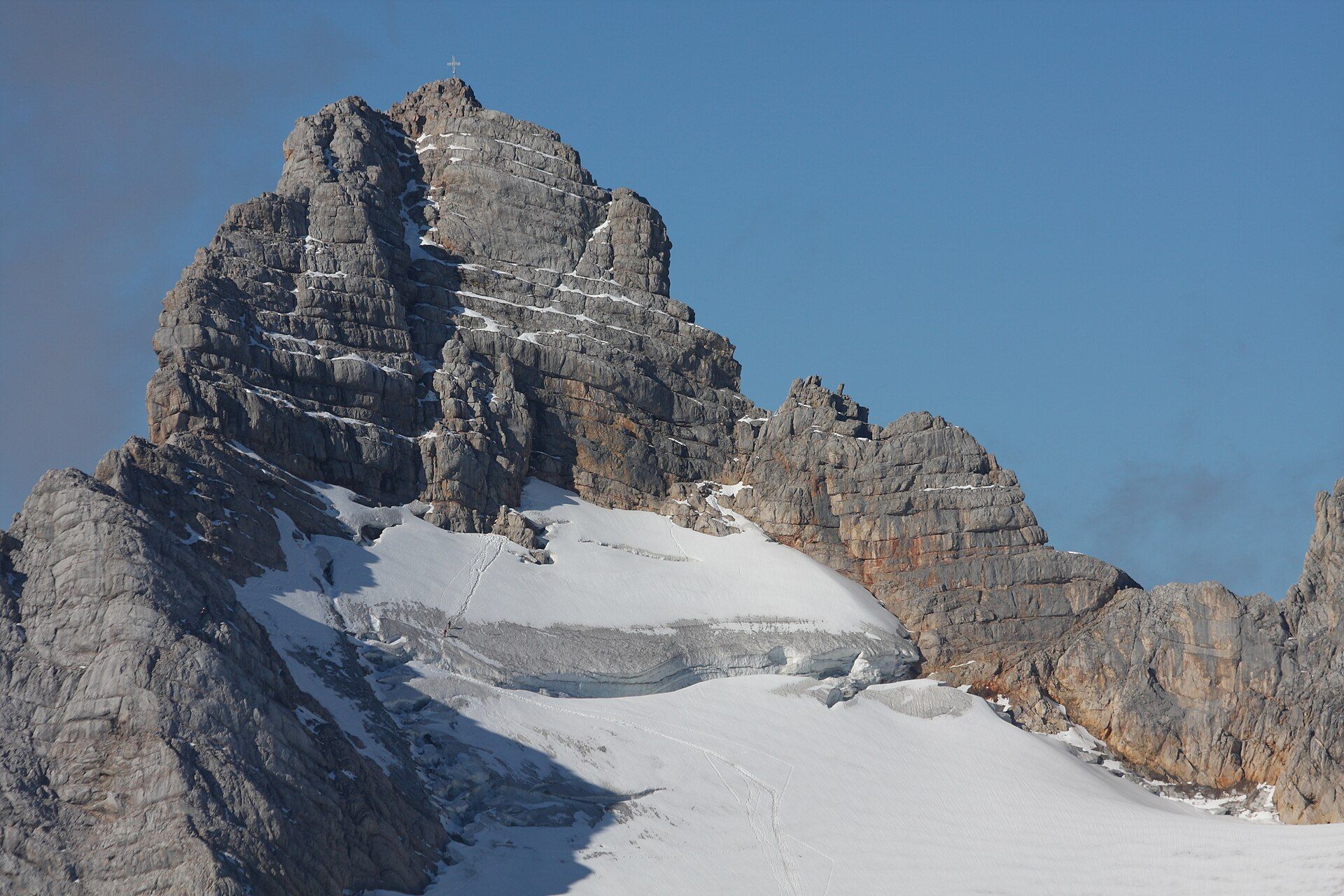
A great limestone massif crowning the Salzkammergut, where the Northern Alps' easternmost glaciers cling below the 2,995-metre Hoher Dachstein, and giant ice caves honeycomb the pale rock above the lakes of the Salzkammergut.
What makes it marvelous
The Dachstein is a mighty block of pale limestone straddling the borders of three Austrian states, topped by the Hoher Dachstein at 2,995 metres. On its high northern shoulders lie the easternmost and northernmost glaciers of the Alps, remnants of a colder age slowly retreating on the summit plateau. Rain and meltwater have riddled the soluble rock with more than two hundred caves, among them the celebrated Giant Ice Cave and Mammoth Cave. Below, glacier-fed lakes and the ancient salt-mining valley of Hallstatt complete a landscape recognised as a UNESCO World Heritage site.
Why visit
Cable cars climb from the valley to the Krippenstein and the Dachstein plateau, opening a high world of ice caves, the vertigo-inducing 'Five Fingers' viewing platform, and a suspension bridge and glass 'Stairway to Nothingness' above sheer cliffs. Below, the mirror-still lakes and the pastel village of Hallstatt make the massif one of the most photographed corners of the Alps — and a place where cave, glacier and lake sit within a single sweep of the eye.
More views of Dachstein
Additional photographs of the actual site — each freely licensed, with its photographer and licence credited.
What to know before you go
🗓️ Best time
Late spring to autumn opens the cable cars, caves and high trails; the ice caves run roughly May to October, while the surrounding lakes and villages are lovely year-round.
🧭 Getting there & access
Reached from the Salzkammergut lakes around Hallstatt and Obertraun; cable cars climb to Krippenstein for the caves and viewpoints and to the Dachstein glacier from the Styrian side.
Good to know
- Bring warm layers even in summer — the ice caves and glacier plateau stay near freezing.
- Cable-car and cave hours are seasonal and weather-dependent; confirm before travelling.
- The high plateau is exposed karst; stay on marked paths and watch the fast-changing weather.
Plan your visit
Moderate🧭 Getting there
From Salzburg (airport SZG) or Bad Ischl
- Travel to Obertraun or Hallstatt in the Salzkammergut by road or rail
- Ride the Krippenstein cable car for the ice caves and viewpoints, or approach the glacier from Ramsau on the Styrian side
- Total travel
- A full day; more to combine caves, plateau and lakes
- Time at site
- Half a day for the caves and viewpoints; longer for the glacier
- Access
- Cable-car and cave tickets required; both are seasonal, roughly May–October, and close in bad weather.
🎒 What to bring & consider
- Warm jacket and gloves for the near-freezing ice caves and plateau
- Sturdy shoes with grip for cave steps and karst paths
- Sun and wind protection on the exposed heights
- A head for heights for the skywalk and suspension bridge
👁️ What to expect
- Crowds
- Busy in summer, especially the caves and the Hallstatt viewpoints; quieter early or late.
- Conditions
- Cold underground and on the plateau even in summer; steep, exposed high trails.
- Facilities
- Cable cars, cave tours, restaurants and viewpoints; full services in the valley towns.
- The view
- The Five Fingers platform jutting over the void, or Hallstatt mirrored in its lake below.
Times and requirements are approximate and change with season, weather, and local rules — confirm permits, fares, and schedules with operators before you travel.
Natural riches of the area
- A 2,995-metre limestone massif
- The easternmost glaciers of the Alps
- Vast ice and limestone cave systems
- Glacier-fed lakes of the Salzkammergut
Local food
- Steirisches Wurzelfleisch
- Styrian boiled pork with root vegetables and horseradish.
- Reinanke
- Whitefish from the Salzkammergut lakes, often pan-fried.
- Ausseer Lebkuchen
- Spiced gingerbread from the Ausseerland near the massif.
The Dachstein is a great massif of pale limestone that crowns the Salzkammergut, the lake district of the Austrian Alps. Straddling the borders of Upper Austria, Styria and Salzburg — which earns it the nickname of the “three-state mountain” — it rises to the Hoher Dachstein at 2,995 metres. On its high shoulders cling the easternmost and northernmost glaciers of the entire Alpine chain, relics of a colder past that are slowly shrinking on the summit plateau.
The massif is as remarkable below ground as above it. Water seeping through the soluble limestone over aeons has hollowed out more than two hundred caves, including the famous Dachstein Giant Ice Cave, hung with frozen cascades, and the sprawling Mammoth Cave. Cable cars from the valley carry visitors up to the Krippenstein, where a cluster of daring viewing platforms — the “Five Fingers”, a suspension bridge and a glass “Stairway to Nothingness” — hang over sheer drops, and to the glacier itself from the Styrian side.
At the foot of all this lie the glacier-fed lakes of the Salzkammergut and the pastel village of Hallstatt, wedged between water and cliff, its salt mines among the oldest in the world. The whole landscape is a UNESCO World Heritage site, and rightly so: few places gather glacier, cave, peak and mirror-still lake so completely into one.
Dachstein: common questions
How do you get to Dachstein?
From Salzburg (airport SZG) or Bad Ischl: Travel to Obertraun or Hallstatt in the Salzkammergut by road or rail; Ride the Krippenstein cable car for the ice caves and viewpoints, or approach the glacier from Ramsau on the Styrian side. Total travel time: A full day; more to combine caves, plateau and lakes.
When is the best time to visit Dachstein?
Late spring to autumn opens the cable cars, caves and high trails; the ice caves run roughly May to October, while the surrounding lakes and villages are lovely year-round.
How long should you spend at Dachstein?
Half a day for the caves and viewpoints; longer for the glacier. Total travel time: A full day; more to combine caves, plateau and lakes.
What should you bring to Dachstein?
Warm jacket and gloves for the near-freezing ice caves and plateau Sturdy shoes with grip for cave steps and karst paths Sun and wind protection on the exposed heights A head for heights for the skywalk and suspension bridge
Do you need a permit or guide for Dachstein?
Cable-car and cave tickets required; both are seasonal, roughly May–October, and close in bad weather.
Is Dachstein crowded, and what are conditions like?
Busy in summer, especially the caves and the Hallstatt viewpoints; quieter early or late. Cold underground and on the plateau even in summer; steep, exposed high trails. Facilities: Cable cars, cave tours, restaurants and viewpoints; full services in the valley towns.
Added Updated
More wonders to explore