Salar de Uyuni
📍 Altiplano, southwestern Bolivia
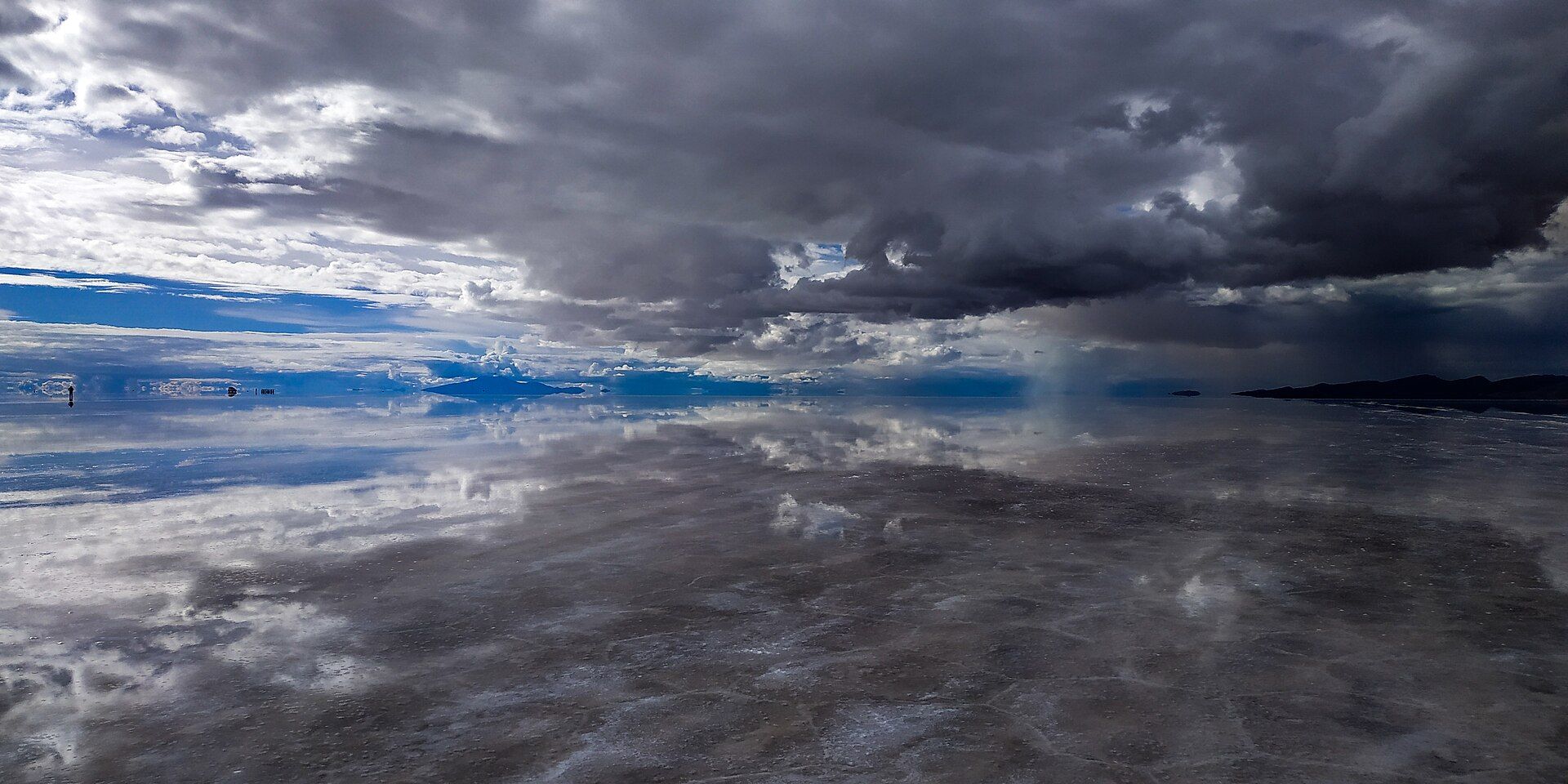
The largest salt flat on Earth — a blinding-white expanse of over 10,000 square kilometres high on the Bolivian Altiplano that becomes, after rain, the world's biggest natural mirror, reflecting the sky so perfectly that the horizon disappears.
What makes it marvelous
The Salar is the dried bed of vast prehistoric lakes, now a crust of salt up to metres thick covering more than 10,500 square kilometres at around 3,660 metres altitude — so flat it varies by barely a metre across its whole width, and used to calibrate satellites. In the dry season it is a dazzling white plain patterned with polygonal salt tiles; when a thin film of water covers it in the wet season, it turns into a perfect mirror, doubling the sky and clouds until the horizon vanishes. Beneath the crust lies a huge share of the world's lithium.
Why visit
Driving out onto an endless white plain that mirrors the sky is one of travel's most surreal experiences — a place where perspective dissolves and every photo looks impossible. Cactus-covered islands, flamingo lagoons, and red and green mineral lakes lie nearby on the high Altiplano.
Still deciding?
Salar de Uyuni comes up most often against these — each one weighs cost, effort, season and crowds side by side.
More views of Salar de Uyuni
Additional photographs of the actual site — each freely licensed, with its photographer and licence credited.
What to know before you go
🗓️ Best time
The dry season (roughly May–October) for the classic white salt-tile scenery and easy driving; the wet season (roughly December–April) for the mirror effect (access can be limited).
🧭 Getting there & access
From the town of Uyuni in southwestern Bolivia (by road, rail, or air via Uyuni's airstrip), on 1–3 day guided 4x4 tours that also take in the wider Altiplano lagoons and deserts.
Good to know
- Choose the season for what you want: white salt tiles (dry) or the sky mirror (wet).
- The altitude is high — acclimatise and protect against fierce sun and cold nights.
- Go with reputable 4x4 operators; the flat is disorienting and vast.
Plan your visit
Moderate🧭 Getting there
From Uyuni (UYU), Bolivia
- Fly La Paz → Uyuni — about 1h
- Or overnight bus from La Paz — roughly 10–12h
- Jeep tours leave Uyuni; the edge of the flat is around 30–45 minutes out
- Total travel
- Half a day flying from La Paz
- Time at site
- A day for the flat itself; three days for the classic circuit down to the southern lagoons
- Access
- No permit for the flat. The Eduardo Avaroa reserve on the three-day circuit charges entry. In practice a tour is mandatory — the salar has no landmarks and vehicles do get lost on it. Operator safety records vary considerably; ask.
🎒 What to bring & consider
- Altitude acclimatisation before you arrive — the flat sits around 3,650m and the circuit climbs well past 4,500m, so flying straight in from sea level is asking for trouble
- Extreme sun protection, sunglasses and lip balm; the salt reflects UV upward and people burn under the chin and nose
- Real cold-weather gear for the nights, which drop below freezing on the circuit
- Cash in bolivianos — there are no ATMs once you leave Uyuni
- A decision about the mirror: it needs a thin film of water, roughly December to April, which is also when parts of the flat become impassable. You cannot have both
👁️ What to expect
- Crowds
- Jeeps gather at sunrise and sunset spots, but the flat is vast enough to feel empty within minutes of driving.
- Conditions
- Hours of rough driving at high altitude, with a large swing between daytime glare and night frost.
- Facilities
- Basic. Salt hotels and simple refuges on the circuit, with limited plumbing and intermittent electricity.
- The view
- The mirror needs standing water; the dry-season hexagon pattern is the other classic. Choose which one you want before you pick dates.
Times and requirements are approximate and change with season, weather, and local rules — confirm permits, fares, and schedules with operators before you travel.
Natural riches of the area
- The largest salt flat on Earth (evaporite crust)
- One of the world's largest lithium reserves beneath the salt
- High-altitude lagoons with three flamingo species
- Surrounding Altiplano deserts, geysers, and mineral lakes
Local food
- Quinoa
- The ancient Andean grain, grown around the Altiplano.
- Llama meat
- A lean, traditional Andean protein, grilled or stewed.
- Salteñas
- Bolivian baked pastries filled with savoury, slightly sweet stew.
The Salar de Uyuni is the closest thing on Earth to standing inside the sky. High on the Bolivian Altiplano at 3,660 metres lies the dried bed of ancient lakes — the largest salt flat in the world, over 10,500 square kilometres of salt crust so astonishingly level that it varies by barely a metre across its entire width, and is used to calibrate satellites from orbit.
In the dry season it is a blinding white plain cracked into a honeycomb of salt tiles; but when a thin sheet of rainwater covers it, it becomes the world’s largest natural mirror, reflecting the clouds so flawlessly that the horizon disappears and you seem to walk on the sky itself. Cactus-studded islands, flamingo-filled lagoons, and red and green mineral lakes surround it, and beneath the salt lies a vast share of the world’s lithium. It is one of the most surreal and beautiful landscapes anywhere.
Set pieces punctuate the white. Incahuasi Island, a stranded outcrop of fossil coral, bristles with giant cacti several metres tall; the dormant volcano Tunupa stands on the northern horizon; and near Colchani, at the salt’s edge, villages still rake and dry it by hand. Most tours open at Uyuni’s eerie ‘train cemetery’, a line of rusting nineteenth-century locomotives abandoned in the desert. Beneath the crust lies one of the largest lithium reserves on Earth — a fact that hangs over the salar’s future as demand for battery metals grows.
Salar de Uyuni: common questions
How do you get to Salar de Uyuni?
From Uyuni (UYU), Bolivia: Fly La Paz → Uyuni — about 1h; Or overnight bus from La Paz — roughly 10–12h; Jeep tours leave Uyuni; the edge of the flat is around 30–45 minutes out. Total travel time: Half a day flying from La Paz.
When is the best time to visit Salar de Uyuni?
The dry season (roughly May–October) for the classic white salt-tile scenery and easy driving; the wet season (roughly December–April) for the mirror effect (access can be limited).
How long should you spend at Salar de Uyuni?
A day for the flat itself; three days for the classic circuit down to the southern lagoons. Total travel time: Half a day flying from La Paz.
What should you bring to Salar de Uyuni?
Altitude acclimatisation before you arrive — the flat sits around 3,650m and the circuit climbs well past 4,500m, so flying straight in from sea level is asking for trouble Extreme sun protection, sunglasses and lip balm; the salt reflects UV upward and people burn under the chin and nose Real cold-weather gear for the nights, which drop below freezing on the circuit Cash in bolivianos — there are no ATMs once you leave Uyuni A decision about the mirror: it needs a thin film of water, roughly December to April, which is also when parts of the flat become impassable. You cannot have both
Do you need a permit or guide for Salar de Uyuni?
No permit for the flat. The Eduardo Avaroa reserve on the three-day circuit charges entry. In practice a tour is mandatory — the salar has no landmarks and vehicles do get lost on it. Operator safety records vary considerably; ask.
Is Salar de Uyuni crowded, and what are conditions like?
Jeeps gather at sunrise and sunset spots, but the flat is vast enough to feel empty within minutes of driving. Hours of rough driving at high altitude, with a large swing between daytime glare and night frost. Facilities: Basic. Salt hotels and simple refuges on the circuit, with limited plumbing and intermittent electricity.
Added Updated