Sajama National Park
📍 Western Altiplano, Oruro Department, Bolivia, on the border with Chile
Bolivia's first protected area: a high Altiplano park crowned by Nevado Sajama, at 6,542 m the country's highest mountain, with some of the world's highest woodland, geysers, hot springs and vicuñas grazing beneath snow-capped volcanoes.
What makes it marvelous
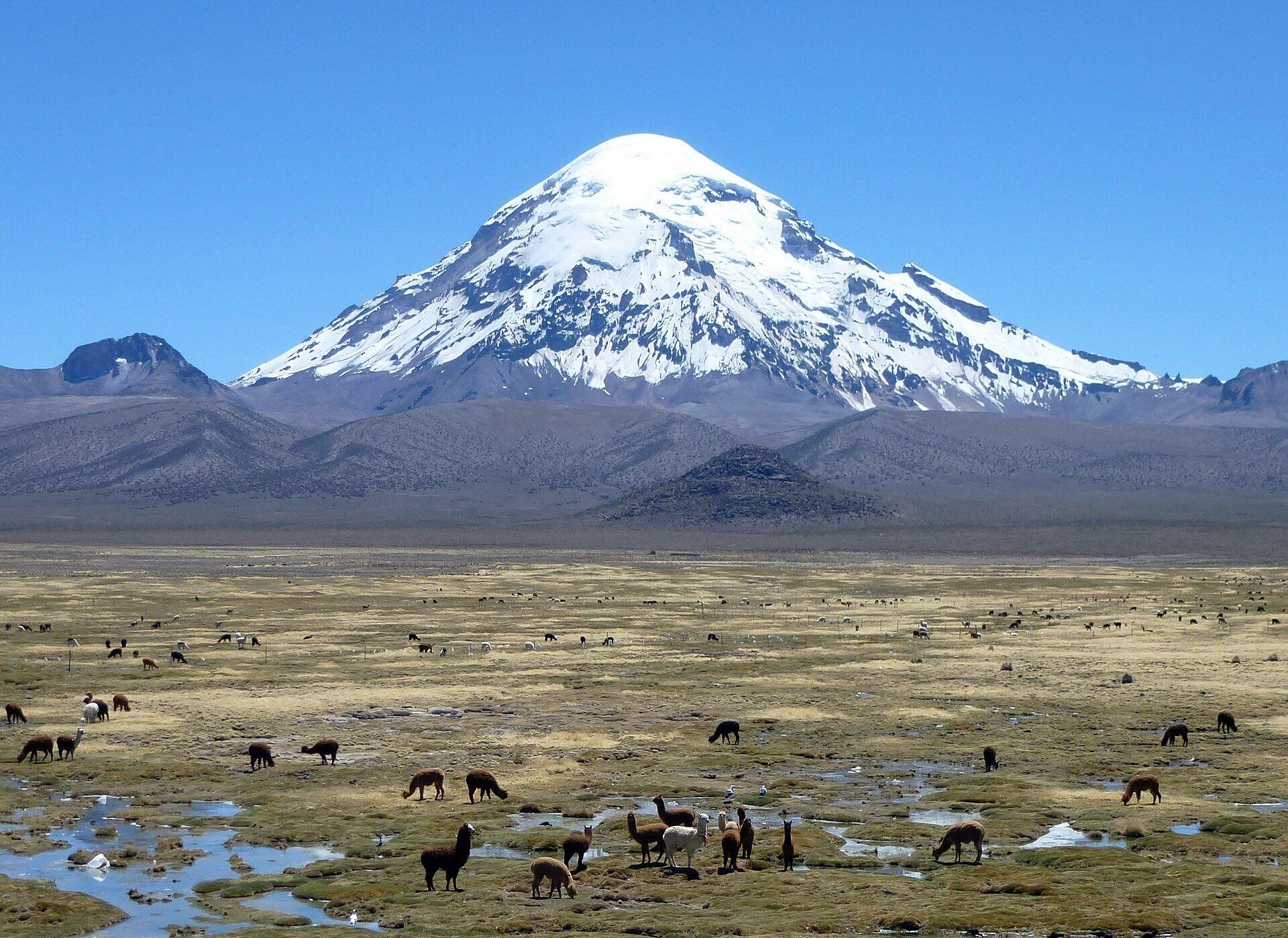
Sajama National Park covers about 1,000 km² of the western Altiplano, at altitudes from about 4,200 m up to the summit of Nevado Sajama, an extinct volcano that at 6,542 m is the highest mountain in Bolivia. On its slopes grow woodlands of queñua (Polylepis), small, twisted trees regarded as some of the highest forests in the world. To the west, on the Chilean border, rise Parinacota and Pomerape, the twin snow cones of the Payachata volcanic group, and the park adjoins Chile's Lauca National Park. Geysers and hot springs bubble up within walking distance of Sajama village, and the grasslands and wetlands hold vicuñas, puna rheas, flamingos and Andean condors. Declared a reserve in 1939, Sajama was Bolivia's first protected area, and it has been on UNESCO's World Heritage Tentative List since 2003.
Why visit
A perfect snow-capped cone rising from open puna, herds of llamas and wild vicuñas on the wetlands, and hot springs to soak in at the end of the day — big, quiet Andean scenery far from the crowds.
What to know before you go
🗓️ Best time
The dry season, roughly May to October, brings clear skies and stable weather; most of the year's rain falls between November and March. Nights are bitterly cold, especially in June and July, when average minimums drop below −9 °C.
🧭 Getting there & access
The paved road between La Paz and Arica in Chile runs past the park. From La Paz, buses heading south towards Oruro stop at the junction town of Patacamaya, where minibuses leave for Sajama village; the village can also be reached from the Tambo Quemado border crossing. Many visitors come on tours or with a hired vehicle from La Paz.
Good to know
- Arrive acclimatised — Sajama village already sits above 4,200 m, so spend a few days at altitude (La Paz, for example) first.
- Bring enough cash in bolivianos; services in the village are basic and there are no banks inside the park.
- Climbing Nevado Sajama is a serious high-altitude mountaineering expedition — go only with experienced guides and full equipment.
Plan your visit
Moderate🧭 Getting there
From La Paz (LPB), by road via Patacamaya
- Take a bus from La Paz towards Oruro and get off at Patacamaya
- Continue by minibus along the La Paz–Arica road to Sajama village
- Walk or drive out to the hot springs, geysers and lagoons from the village
- Total travel
- Most of a day by public transport from La Paz; quicker with a private vehicle
- Time at site
- Two or three days for the hot springs, geysers and walks; a week or more for a guided ascent of Nevado Sajama
- Access
- The park entrance fee is paid in Sajama village. The paved international highway gives easy access, but tracks inside the park are unpaved and there is no public transport beyond the village.
🎒 What to bring & consider
- Several days of acclimatisation before arriving
- Very warm layers, hat and gloves — nights fall far below freezing
- Strong sun protection and sunglasses
- Cash in bolivianos for lodging, meals and the park fee
👁️ What to expect
- Crowds
- Few visitors; you may have the hot springs and trails largely to yourself.
- Conditions
- Thin air, strong sun, wind and big temperature swings; walking routes are mostly flat but long.
- Facilities
- Simple family-run lodgings and meals in Sajama village; little else.
- The view
- The snow cone of Nevado Sajama above wetlands dotted with grazing llamas and alpacas, best in clear dry-season light.
Times and requirements are approximate and change with season, weather, and local rules — confirm permits, fares, and schedules with operators before you travel.
Natural riches of the area
- Nevado Sajama, 6,542 m, Bolivia's highest mountain
- Queñua (Polylepis) woodlands, among the highest forests on Earth
- Geysers and hot springs near Sajama village
- High Andean wetlands (bofedales) with vicuñas, puna rheas and flamingos
- The snow-capped Payachata volcanoes on the Chilean border
Local food
- Charque
- Dried llama meat, a staple of the high Altiplano.
- Quinoa soup
- Sopa de quinua, a warming bowl served across the high plateau.
In the far west of Bolivia, where the Altiplano runs up against the Chilean border, a single snow-capped cone dominates the horizon. Nevado Sajama, an extinct volcano, rises to 6,542 metres — the highest point in the country — and gives its name to Bolivia’s oldest protected area, declared a reserve in 1939.
The park covers about 1,000 square kilometres, and none of it lies below about 4,200 metres. Even so, trees grow here: on Sajama’s slopes, woodlands of queñua, a hardy Polylepis, cling on at altitudes far above most of the world’s treelines and are counted among the highest forests in the world. Below them spread grasslands and green wetlands where llamas and alpacas graze alongside wild vicuñas, while puna rheas, flamingos and Andean condors share the open country.
Volcanic heat is never far away. Geysers and hot springs rise within walking distance of Sajama village, and on the western edge of the park the twin snow cones of the Payachata volcanoes, Parinacota and Pomerape, straddle the border with Chile, where the park meets Chile’s Lauca National Park.
Sajama is reached along the paved highway from La Paz to Arica, yet it stays wonderfully quiet. Come in the dry season for clear skies, give yourself time to acclimatise, and pack for nights that fall far below freezing.
Sajama National Park: common questions
How do you get to Sajama National Park?
From La Paz (LPB), by road via Patacamaya: Take a bus from La Paz towards Oruro and get off at Patacamaya; Continue by minibus along the La Paz–Arica road to Sajama village; Walk or drive out to the hot springs, geysers and lagoons from the village. Total travel time: Most of a day by public transport from La Paz; quicker with a private vehicle.
When is the best time to visit Sajama National Park?
The dry season, roughly May to October, brings clear skies and stable weather; most of the year's rain falls between November and March. Nights are bitterly cold, especially in June and July, when average minimums drop below −9 °C.
How long should you spend at Sajama National Park?
Two or three days for the hot springs, geysers and walks; a week or more for a guided ascent of Nevado Sajama. Total travel time: Most of a day by public transport from La Paz; quicker with a private vehicle.
What should you bring to Sajama National Park?
Several days of acclimatisation before arriving Very warm layers, hat and gloves — nights fall far below freezing Strong sun protection and sunglasses Cash in bolivianos for lodging, meals and the park fee
Do you need a permit or guide for Sajama National Park?
The park entrance fee is paid in Sajama village. The paved international highway gives easy access, but tracks inside the park are unpaved and there is no public transport beyond the village.
Is Sajama National Park crowded, and what are conditions like?
Few visitors; you may have the hot springs and trails largely to yourself. Thin air, strong sun, wind and big temperature swings; walking routes are mostly flat but long. Facilities: Simple family-run lodgings and meals in Sajama village; little else.
Added