The Seven Rila Lakes
📍 Rila National Park, Rila Mountains, southwestern Bulgaria
Seven glacial tarns arranged one above the other on a mountain staircase between 2,100 and 2,500 metres, each named for the shape the ice left it in — the Eye, the Kidney, the Tear, the Twin.
What makes it marvelous
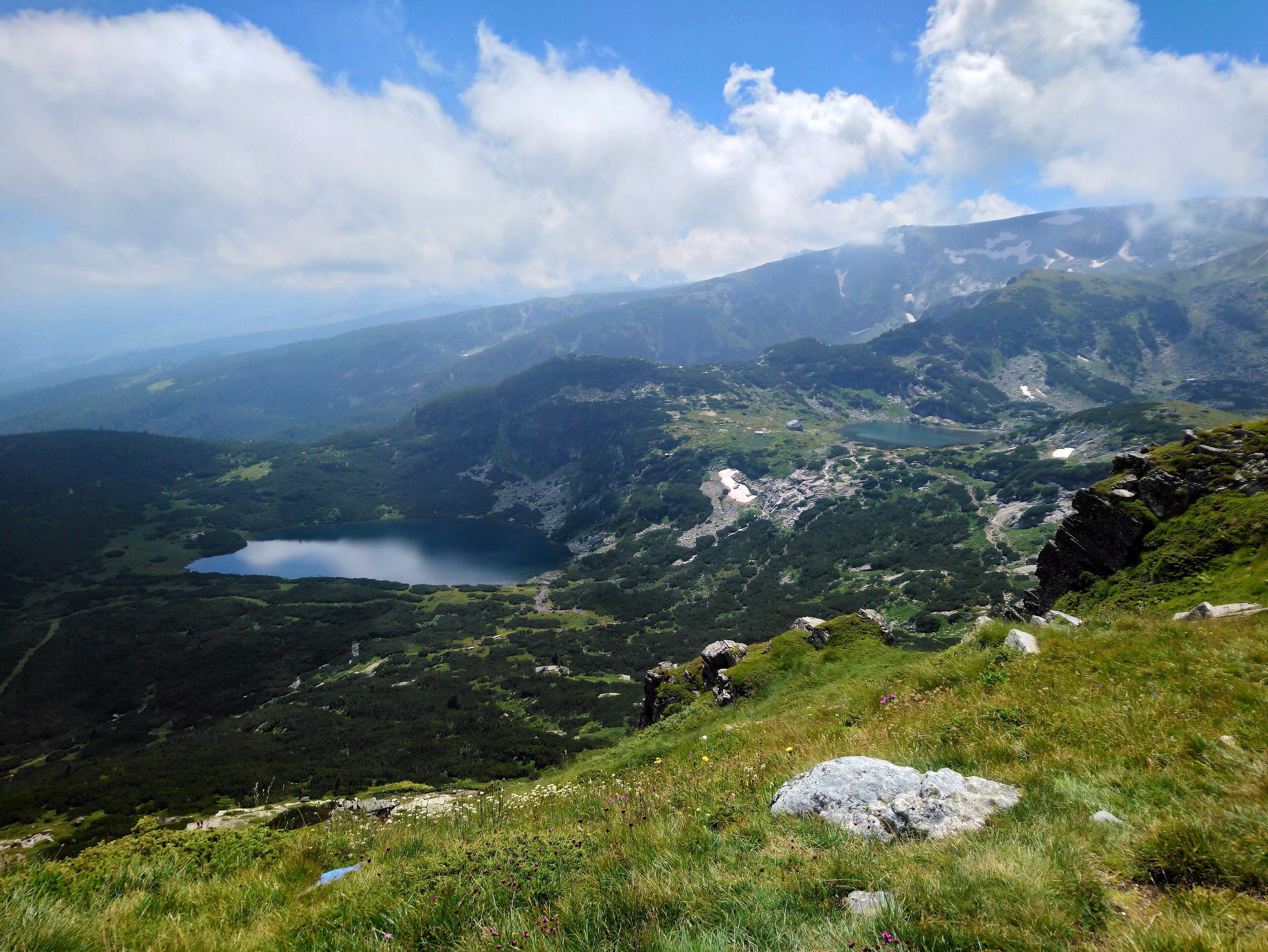
These are cirque lakes: hollows gouged out by ice-age glaciers and left holding water when the ice went. What makes the Rila group unusual is the arrangement. The seven sit in a stepped sequence up the northwestern flank of the Rila massif, each one a little higher than the last, linked by streams that fall between them in small cascades, so that water leaving the top lake works its way down through all of them and out of the lowest to become the Dzherman River. Each lake is named for its most obvious feature, which is a useful piece of folk taxonomy: Salzata, the Tear, for water clear enough to see a long way into; Okoto, the Eye, almost perfectly oval and at 37.5 metres the deepest cirque lake in Bulgaria; Babreka, the Kidney, with the steepest shores of the group; Bliznaka, the Twin, the largest by area; Trilistnika, the Trefoil, irregular and low-shored; Ribnoto Ezero, the Fish Lake, the shallowest; and Dolnoto Ezero, the Lower Lake, where everything collects. They sit inside Rila National Park, Bulgaria's largest at 810 square kilometres, which holds some 120 glacial lakes in total and rises to Musala at 2,925 metres — the highest summit in the Balkan Peninsula.
Why visit
Climb above the lakes and you see all seven at once, stepped down the mountainside with the cascades linking them — a view that explains its own geology without needing a sign. It is also unusually accessible high country: a chairlift takes you most of the way up, and the circuit between the lakes is a walk rather than a climb.
What to know before you go
🗓️ Best time
July to September is the practical season, when the lakes are ice-free, the chalet is open and the risk of sudden storms is lowest. The lakes usually freeze around October and do not melt out before June, with ice reaching up to two metres thick. Outside summer the weather here turns severe quickly.
🧭 Getting there & access
Around two hours from Sofia by road to the Panichishte area, where a chairlift runs up toward the Rila Lakes chalet. From the top station the circuit of the lakes is a walk of a few hours, climbing to a ridge viewpoint above the highest of them. Walking up from the bottom instead adds a couple of hours and a lot of height.
Good to know
- Go up early. Cloud builds over the cirque by mid-afternoon and takes the view with it.
- Weekends in August are the busiest days on any mountain in Bulgaria — come midweek.
- The ridge above the top lake is where the whole staircase becomes visible; the lakeside path alone does not show it.
- Check chairlift operating days before travelling; it does not run every day out of season.
Plan your visit
Moderate🧭 Getting there
From Sofia (SOF), Bulgaria
- Fly into Sofia
- Drive or take a transfer about two hours south to Panichishte
- Ride the chairlift up toward the Rila Lakes chalet
- Walk the circuit of the lakes and up to the ridge viewpoint
- Total travel
- About 2 hours from Sofia to the lift
- Time at site
- A long day, or an overnight at the chalet
- Access
- The park is open and free to enter; the chairlift is ticketed and does not run every day outside the summer season. Beds at the chalet by the Fish Lake should be booked ahead in July and August. Camping in the cirque is restricted — check current rules rather than assuming.
🎒 What to bring & consider
- Proper walking shoes; the paths are rocky and get slippery fast in rain
- Full waterproofs — storms build over the cirque with little warning
- Warm layers even in August; it is over 2,000 m and exposed
- Water and food, since the chalet is the only supply point
- An early start, before the cloud and the crowds
👁️ What to expect
- Crowds
- Very busy on summer weekends, when this is one of Bulgaria's most-visited natural sites. Quiet midweek and early.
- Conditions
- Cool and windy at altitude, with rapid weather changes. Steady uphill walking on stone paths.
- Facilities
- A chalet with beds and simple food beside the Fish Lake; the lift station below. Nothing else in the cirque.
- The view
- All seven lakes stepped down the mountainside from the ridge above the highest of them, in the clear light of early morning.
Times and requirements are approximate and change with season, weather, and local rules — confirm permits, fares, and schedules with operators before you travel.
Natural riches of the area
- Seven glacial cirque lakes between roughly 2,100 and 2,500 m
- Okoto, the Eye — at 37.5 m the deepest cirque lake in Bulgaria
- Streams and cascades linking the lakes into a single drainage staircase
- Rila National Park, 810 km², with about 120 glacial lakes in total
- Musala, 2,925 m, the highest summit in the Balkan Peninsula
Local food
- Banitsa
- Layered filo pastry with white brined cheese and egg, eaten at any hour.
- Shopska salata
- Tomato, cucumber, pepper and grated sirene — the standard Bulgarian starter.
- Bob chorba
- Bean soup with savory herb, the mountain-hut staple.
- Kiselo mlyako
- Bulgarian yoghurt, thick and sharp, eaten plain or drunk as ayran.
Ice-age glaciers left hollows all over the Rila massif — Bulgaria’s national park here holds around 120 lakes filling them — but in the northwest corner they left something more deliberate-looking. Seven cirque lakes sit stepped up the mountainside between roughly 2,100 and 2,500 metres, each a little higher than the one below, joined by streams that drop between them in short cascades. Water leaving the highest lake passes through all seven and out of the lowest as the Dzherman River.
The names are the best part, because they are descriptions rather than dedications. The highest is Salzata, the Tear, for water clear enough to see a long way down through. Below it is Okoto, the Eye, an almost perfect oval and, at 37.5 metres, the deepest cirque lake in Bulgaria. Then Babreka, the Kidney, which has the steepest shores of the group; Bliznaka, the Twin, the largest by surface; Trilistnika, the Trefoil, irregular and low-banked; Ribnoto Ezero, the Fish Lake, the shallowest, with the mountain chalet on its northeastern shore; and finally Dolnoto Ezero, the Lower Lake, where everything gathers.
Seen from the lakeside path they are seven pretty tarns. Seen from the ridge above the top one they become a single object — a staircase of water down a glacial cirque, with the whole drainage visible at once. That climb is the difference between a nice walk and understanding what you are looking at, and it takes about an hour.
The practical constraint is the season. These lakes usually freeze in October under ice that can reach two metres thick, and they do not clear before June. July to September is the window, storms build over the cirque most summer afternoons, and August weekends bring a good proportion of Sofia with them. Go early, and go midweek.
The Seven Rila Lakes: common questions
How do you get to The Seven Rila Lakes?
From Sofia (SOF), Bulgaria: Fly into Sofia; Drive or take a transfer about two hours south to Panichishte; Ride the chairlift up toward the Rila Lakes chalet; Walk the circuit of the lakes and up to the ridge viewpoint. Total travel time: About 2 hours from Sofia to the lift.
When is the best time to visit The Seven Rila Lakes?
July to September is the practical season, when the lakes are ice-free, the chalet is open and the risk of sudden storms is lowest. The lakes usually freeze around October and do not melt out before June, with ice reaching up to two metres thick. Outside summer the weather here turns severe quickly.
How long should you spend at The Seven Rila Lakes?
A long day, or an overnight at the chalet. Total travel time: About 2 hours from Sofia to the lift.
What should you bring to The Seven Rila Lakes?
Proper walking shoes; the paths are rocky and get slippery fast in rain Full waterproofs — storms build over the cirque with little warning Warm layers even in August; it is over 2,000 m and exposed Water and food, since the chalet is the only supply point An early start, before the cloud and the crowds
Do you need a permit or guide for The Seven Rila Lakes?
The park is open and free to enter; the chairlift is ticketed and does not run every day outside the summer season. Beds at the chalet by the Fish Lake should be booked ahead in July and August. Camping in the cirque is restricted — check current rules rather than assuming.
Is The Seven Rila Lakes crowded, and what are conditions like?
Very busy on summer weekends, when this is one of Bulgaria's most-visited natural sites. Quiet midweek and early. Cool and windy at altitude, with rapid weather changes. Steady uphill walking on stone paths. Facilities: A chalet with beds and simple food beside the Fish Lake; the lift station below. Nothing else in the cirque.
Added
More wonders to explore