Retezat National Park
📍 Retezat Mountains, Hunedoara County, Southern Carpathians, Romania
Romania's first national park, declared in 1935 — sixty peaks above 2,300 metres, around eighty glacial lakes scattered between them, and some of the last untouched old-growth forest in Europe.
What makes it marvelous
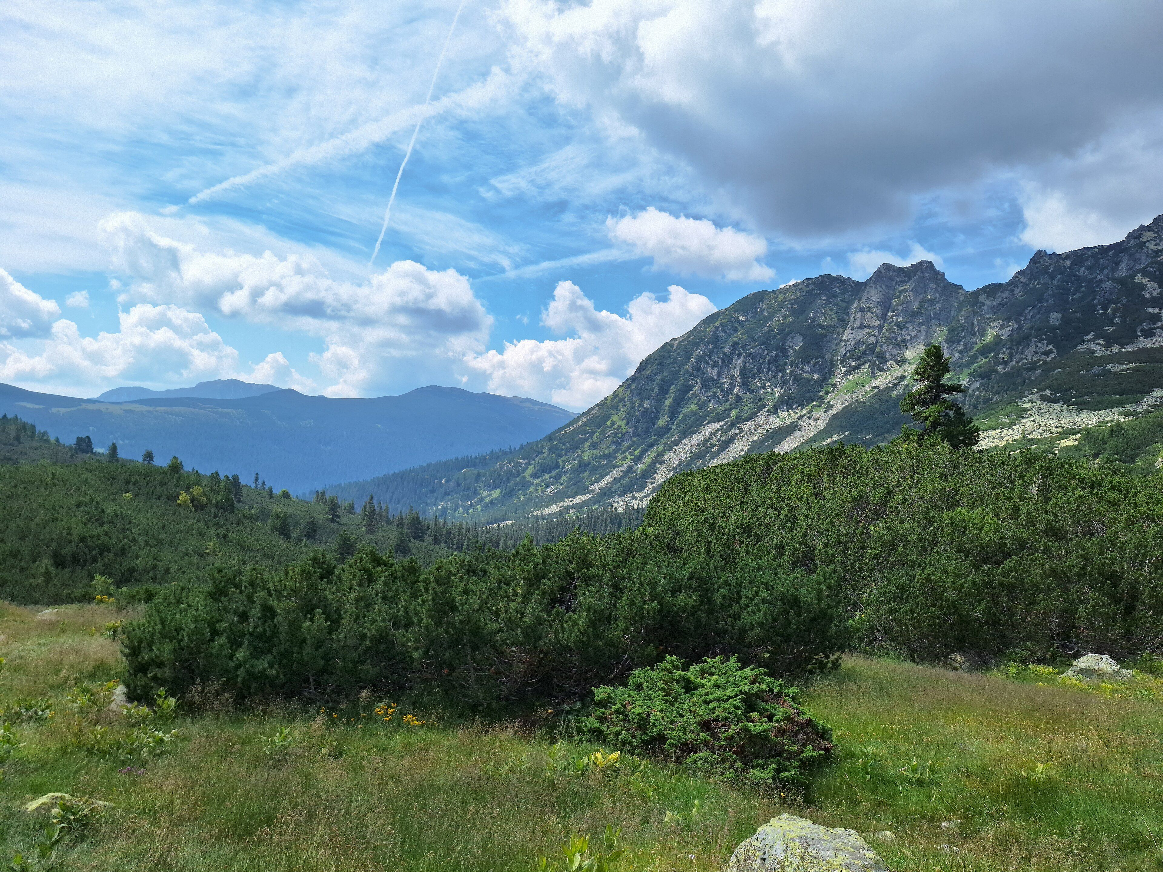
Retezat is what the last ice age left behind in the Southern Carpathians and nobody subsequently ruined. The park covers 380 square kilometres and contains more than sixty peaks over 2,300 metres — Peleaga, the highest, reaches 2,509 — with about eighty glacial lakes filling the cirques beneath them, of which 54 hold water year-round. Bucura, at roughly 2,040 metres below Peleaga, is the largest glacial lake in Romania. The flora is the reason it was protected in the first place: around 1,190 plant species, more than a third of everything that grows in Romania, packed into one massif. The Gemenele reserve at its heart is 1,800 hectares of strictly protected old-growth, part of one of the largest surviving areas of untouched mixed forest on the continent. Fifty-five mammal species live here, close to a quarter of Romania's total, including grey wolf, brown bear, lynx, wildcat and chamois.
Why visit
Few places in Europe put this many high glacial lakes within a few days' walking of each other, and fewer still combine that with genuinely primeval forest lower down. Romania also holds Europe's largest populations of brown bear, wolf and lynx outside Russia, and Retezat is one of the places where all three still range. It is high, quiet and comparatively unvisited for a European national park of this quality.
What to know before you go
🗓️ Best time
July to September is the reliable walking season — the high lakes are ice-free, the huts are staffed and the passes are clear. June can still hold snow above 2,000 metres. Winter turns the park into a serious ski-touring and snowshoe objective.
🧭 Getting there & access
The usual approaches are from Hațeg or Petroșani in Hunedoara County, roughly an hour from either to the trailheads. Cabana Pietrele on the northern side and the Bucura basin in the centre are the main bases. There is no road into the interior — everything above the valleys is reached on foot, on marked trails.
Good to know
- Camp at Bucura only in the designated area; the lakeshore is heavily used and the damage shows.
- Bears live here and are not a curiosity. Store food properly and make noise on forest trails.
- The high ridges get afternoon thunderstorms through summer — be off them by early afternoon.
- Water sources are plentiful high up but not on the ridge traverses. Fill at the lakes.
Plan your visit
Strenuous🧭 Getting there
From Timișoara or Sibiu, Romania
- Fly to Timișoara, Sibiu or Cluj-Napoca
- Drive to Hațeg or Petroșani in Hunedoara County
- Continue by road to Cabana Pietrele or another valley trailhead
- Walk in to the Bucura basin and the high lakes
- Total travel
- Most of a day from the nearest airport
- Time at site
- 3–5 days for the lake basins and a ridge traverse
- Access
- Entry is free and trails are open, but the Gemenele scientific reserve at the core is closed to visitors and the boundary is marked — respect it. Camping is restricted to designated areas, notably at Bucura. Huts should be booked ahead in August.
🎒 What to bring & consider
- A tent and full camping kit if you plan the high lakes; hut capacity is limited
- Mountain boots and poles for long scree and boulder days
- Proper food storage and bear awareness
- Layers for weather that turns over in an hour above 2,000 m
- A paper map; phone signal is patchy in the basins
👁️ What to expect
- Crowds
- Bucura is busy in August with Romanian walkers. The western massif and the ridges are quiet almost always.
- Conditions
- High, exposed and rocky above the treeline; dense old forest below it. Long days between shelters.
- Facilities
- Mountain huts (cabane) at the valley heads with beds and simple food. Nothing on the high plateau.
- The view
- Bucura from the slope above it in early morning, the surrounding peaks reflected before the wind gets up.
Times and requirements are approximate and change with season, weather, and local rules — confirm permits, fares, and schedules with operators before you travel.
Natural riches of the area
- More than sixty peaks above 2,300 m; Peleaga, the highest, at 2,509 m
- About eighty glacial lakes, 54 of them permanent, including Bucura — Romania's largest
- Around 1,190 plant species, over a third of the flora of Romania
- The Gemenele strict reserve — 1,800 ha of untouched old-growth forest
- Grey wolf, brown bear, lynx, wildcat and chamois among 55 mammal species
Local food
- Bulz
- Baked polenta stuffed with sheep's cheese — shepherd food, and the standard mountain plate.
- Ciorbă de burtă
- A sour tripe soup, thickened with cream and sharpened with vinegar and garlic.
- Brânză de burduf
- Strong sheep's cheese matured in bark or a skin bag, made across the Carpathians.
- Afinată
- Bilberry liqueur, made from the fruit that carpets the slopes in late summer.
Romania set Retezat aside in 1935, which made it the country’s first national park and one of the earlier ones in Europe. The reason was botanical: scientists had been arguing since the early nineteenth century that the flora of this particular massif was extraordinary, and they were right. Around 1,190 plant species grow inside its 380 square kilometres — more than a third of everything that grows in Romania, concentrated in one range.
The shape of the place is glacial. More than sixty peaks rise above 2,300 metres, Peleaga topping out at 2,509, and beneath them sit roughly eighty lakes filling the cirques the ice carved out, 54 of which hold water all year. Bucura, at about 2,040 metres, is the largest glacial lake in the country, and the basin around it is where most walkers end up camping. Lower down, in the Gemenele reserve, 1,800 hectares of forest have never been logged — part of one of the largest genuinely untouched mixed-forest landscapes left on the continent.
Fifty-five mammal species live here, close to a quarter of Romania’s total, and the list includes grey wolf, brown bear, lynx, wildcat and chamois. Romania holds Europe’s largest populations of all three big carnivores outside Russia, and Retezat is one of the places where their ranges still overlap properly.
Protection has not been uninterrupted. Logging and sheep grazing both increased sharply after 1990. In 2006 the state ruled in favour of heirs claiming 10,000 hectares of the Retezat Mountains — including large parts of the park — under restitution law; the Romanian Academy fought it, and in 2022 a court found the transfer illegal and the land returned to public ownership. That the argument took sixteen years to settle says something about how thin the line is between a protected landscape and a contested asset.
Retezat National Park: common questions
How do you get to Retezat National Park?
From Timișoara or Sibiu, Romania: Fly to Timișoara, Sibiu or Cluj-Napoca; Drive to Hațeg or Petroșani in Hunedoara County; Continue by road to Cabana Pietrele or another valley trailhead; Walk in to the Bucura basin and the high lakes. Total travel time: Most of a day from the nearest airport.
When is the best time to visit Retezat National Park?
July to September is the reliable walking season — the high lakes are ice-free, the huts are staffed and the passes are clear. June can still hold snow above 2,000 metres. Winter turns the park into a serious ski-touring and snowshoe objective.
How long should you spend at Retezat National Park?
3–5 days for the lake basins and a ridge traverse. Total travel time: Most of a day from the nearest airport.
What should you bring to Retezat National Park?
A tent and full camping kit if you plan the high lakes; hut capacity is limited Mountain boots and poles for long scree and boulder days Proper food storage and bear awareness Layers for weather that turns over in an hour above 2,000 m A paper map; phone signal is patchy in the basins
Do you need a permit or guide for Retezat National Park?
Entry is free and trails are open, but the Gemenele scientific reserve at the core is closed to visitors and the boundary is marked — respect it. Camping is restricted to designated areas, notably at Bucura. Huts should be booked ahead in August.
Is Retezat National Park crowded, and what are conditions like?
Bucura is busy in August with Romanian walkers. The western massif and the ridges are quiet almost always. High, exposed and rocky above the treeline; dense old forest below it. Long days between shelters. Facilities: Mountain huts (cabane) at the valley heads with beds and simple food. Nothing on the high plateau.
Added
More wonders to explore