Mount Fuji
📍 Honshū, Japan
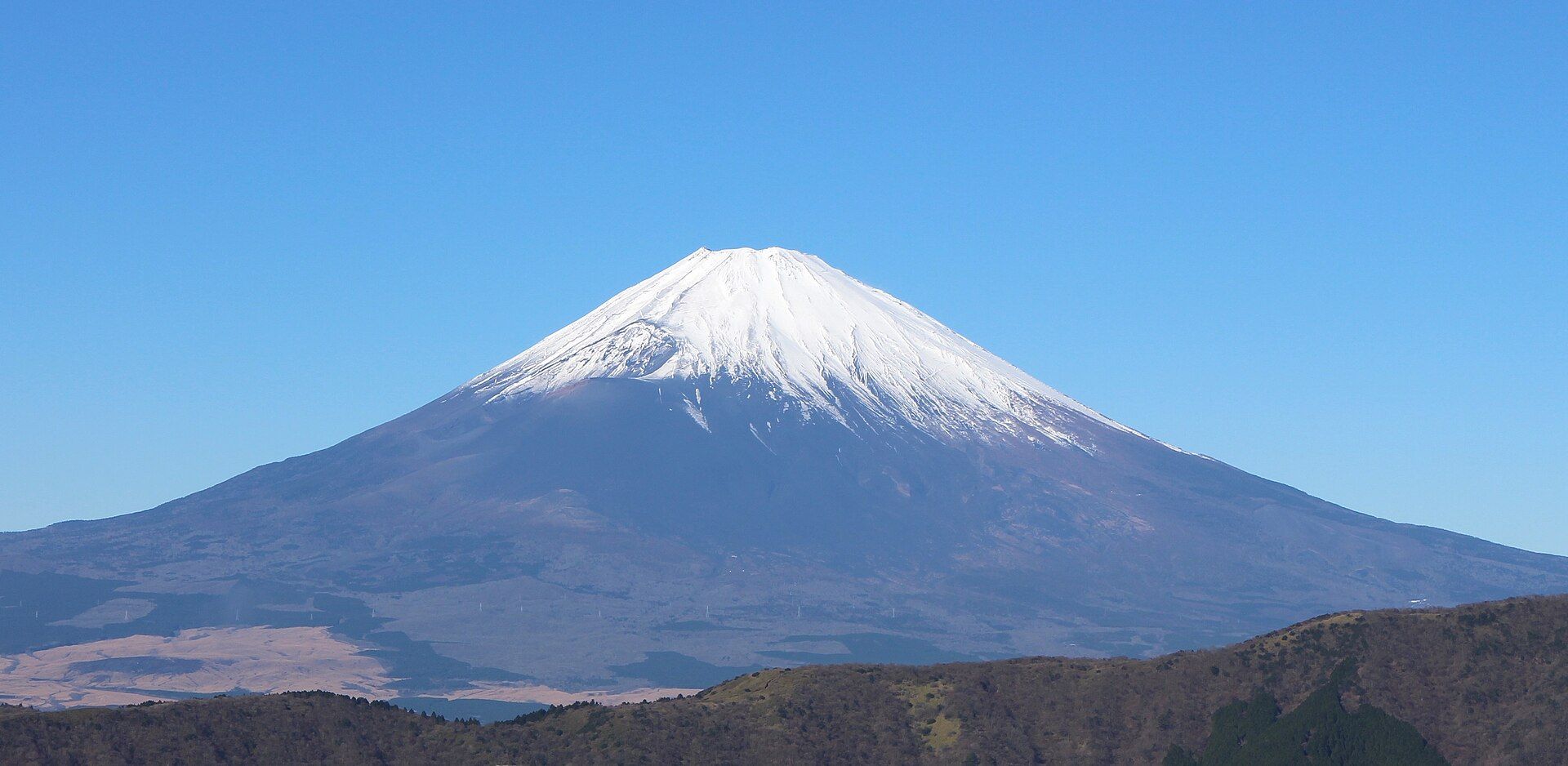
Japan's highest peak — an almost perfectly symmetrical, snow-capped stratovolcano rising to 3,776 metres, standing alone above the plains and visible on a clear day from central Tokyo, a hundred kilometres away.
What makes it marvelous
Fuji is an active stratovolcano whose graceful cone was built by successive eruptions, the most recent in 1707. Its near-perfect symmetry, standing alone above the surrounding plains and lakes, has made it one of the most recognisable mountains on Earth and a subject of Japanese art for centuries. It is inscribed by UNESCO as a cultural rather than a natural site, in recognition of how thoroughly it has shaped Japanese art and identity for well over a thousand years.
Why visit
Whether admired from the Fuji Five Lakes, framed by cherry blossom or a passing bullet train, or climbed through the night to watch the sunrise (goraikō) from the summit, Fuji is unforgettable. The classic reflected view and the overnight climb are both bucket-list experiences.
Still deciding?
Mount Fuji comes up most often against these — each one weighs cost, effort, season and crowds side by side.
More views of Mount Fuji
Additional photographs of the actual site — each freely licensed, with its photographer and licence credited.
What to know before you go
🗓️ Best time
The official climbing season is roughly early July to early September, when trails and mountain huts are open. For views, autumn and winter offer the clearest air and the snow-capped cone.
🧭 Getting there & access
About two hours from Tokyo. Climbers start from stations like the Fujinomiya or Yoshida 5th Station; the Fuji Five Lakes and Hakone areas offer the classic reflected views.
Good to know
- Climb only in season and pace for altitude; start the summit push to catch sunrise.
- Reserve mountain huts in advance and follow current access/permit rules.
- For the postcard view, head to the Fuji Five Lakes on a clear day.
Plan your visit
Strenuous🧭 Getting there
From Tokyo, via Kawaguchiko or Gotemba
- Express bus Shinjuku → Kawaguchiko — roughly 2h–2h30 depending on traffic
- Or train via Otsuki to the Fujikyu line
- To climb: bus Kawaguchiko → Subaru Line 5th Station — about 1h
- Total travel
- Half a day from Tokyo to the lakes
- Time at site
- A day for the lake viewpoints; the climb is normally an overnight — roughly 5–7h up, 3–5h down
- Access
- The official climbing season is short, roughly early July to early September. Outside it the huts and trails are shut and the mountain becomes a serious alpine proposition that kills unprepared people most years. The Yoshida trail now runs an entry system with a daily climber cap, a fee and overnight rules — these have changed repeatedly, so check the prefecture's current climbing portal rather than an old guide.
🎒 What to bring & consider
- Proper cold-weather layers, hat and gloves — the summit hovers near freezing with wind even in August
- A headlamp; the classic ascent walks through the night for sunrise
- Altitude awareness — 3,776m is high enough that altitude sickness is common, and descending is the only cure
- Cash for huts and the paid toilets
- Your own rubbish bag — there are no bins anywhere on the mountain
👁️ What to expect
- Crowds
- The Yoshida trail is genuinely congested in season, with slow-moving queues on the final section before dawn. Other trails are quieter but have fewer huts.
- Conditions
- Relentless volcanic scree and rock steps. No technical climbing, but sustained, and the weather turns fast.
- Facilities
- Mountain huts along the Yoshida route in season, with paid toilets and hot food. Nothing at all off-season.
- The view
- The reflected cone from Lake Kawaguchi needs still air and a clear sky. The mountain spends much of the year in cloud; winter mornings offer the best odds.
Times and requirements are approximate and change with season, weather, and local rules — confirm permits, fares, and schedules with operators before you travel.
Natural riches of the area
- An active, symmetrical stratovolcano
- Crater-fed springs and the Fuji Five Lakes
- Fertile volcanic soils and forested lower slopes
- A landscape central to Japanese art for over a thousand years
Local food
- Hōtō
- A hearty Yamanashi noodle stew with pumpkin and vegetables, from Fuji's foothills.
- Soba
- Buckwheat noodles, often made with pure mountain spring water.
- Fujinomiya yakisoba
- A local fried-noodle specialty from the town at Fuji's base.
Few mountains are as instantly recognisable as Fuji. A near-perfectly symmetrical volcanic cone rising alone to 3,776 metres above the plains and lakes of Honshū, snow on its summit for much of the year, it has been the emblem of Japan and a subject of its art for centuries. It is an active volcano — its last eruption was in 1707 — and its shape is the tidy work of many eruptions layering ash and lava into that famous silhouette.
Fuji is as much a cultural presence as a physical one; UNESCO lists it as a cultural site, in recognition of how thoroughly it has shaped Japanese art and identity over more than a thousand years. You can meet it in two classic ways: from below, reflected in the Fuji Five Lakes on a clear day, or from above, having climbed through the night in season to stand on the summit for the sunrise. Either way, it lives up to its reputation.
Fuji has shaped Japanese art as much as its skyline: Hokusai’s woodblock series Thirty-Six Views of Mount Fuji, which includes the famous Great Wave, helped make the cone an emblem recognised worldwide. Four routes climb it — Yoshida, the busiest and best served with huts; Subashiri; Gotemba, the longest; and Fujinomiya, the shortest — and at the top a Shinto shrine sits beside the crater, ringed by an hour-long rim walk called the ohachimeguri. On a clear day the mountain is visible from central Tokyo, around 100 kilometres away, which is part of why it looms so large in the national imagination.
Mount Fuji: common questions
How do you get to Mount Fuji?
From Tokyo, via Kawaguchiko or Gotemba: Express bus Shinjuku → Kawaguchiko — roughly 2h–2h30 depending on traffic; Or train via Otsuki to the Fujikyu line; To climb: bus Kawaguchiko → Subaru Line 5th Station — about 1h. Total travel time: Half a day from Tokyo to the lakes.
When is the best time to visit Mount Fuji?
The official climbing season is roughly early July to early September, when trails and mountain huts are open. For views, autumn and winter offer the clearest air and the snow-capped cone.
How long should you spend at Mount Fuji?
A day for the lake viewpoints; the climb is normally an overnight — roughly 5–7h up, 3–5h down. Total travel time: Half a day from Tokyo to the lakes.
What should you bring to Mount Fuji?
Proper cold-weather layers, hat and gloves — the summit hovers near freezing with wind even in August A headlamp; the classic ascent walks through the night for sunrise Altitude awareness — 3,776m is high enough that altitude sickness is common, and descending is the only cure Cash for huts and the paid toilets Your own rubbish bag — there are no bins anywhere on the mountain
Do you need a permit or guide for Mount Fuji?
The official climbing season is short, roughly early July to early September. Outside it the huts and trails are shut and the mountain becomes a serious alpine proposition that kills unprepared people most years. The Yoshida trail now runs an entry system with a daily climber cap, a fee and overnight rules — these have changed repeatedly, so check the prefecture's current climbing portal rather than an old guide.
Is Mount Fuji crowded, and what are conditions like?
The Yoshida trail is genuinely congested in season, with slow-moving queues on the final section before dawn. Other trails are quieter but have fewer huts. Relentless volcanic scree and rock steps. No technical climbing, but sustained, and the weather turns fast. Facilities: Mountain huts along the Yoshida route in season, with paid toilets and hot food. Nothing at all off-season.
Added Updated