Lofoten Islands
📍 Nordland, Arctic Norway
A chain of dramatic Arctic islands where jagged granite peaks rise straight from the sea above white beaches and red fishing villages — improbably mild for its latitude, and lit by the midnight sun and the northern lights.
What makes it marvelous
Lofoten's peaks are ancient, hard granite and gneiss, sharpened by glaciers into serrated ridges that plunge to turquoise water and surprisingly white, fine-sand beaches. Though it lies well inside the Arctic Circle, the Gulf Stream keeps it far milder than its latitude suggests, and the surrounding seas host one of the world's great cod fisheries — the basis of the islands' iconic stockfish trade for over a thousand years.
Why visit
The scenery is relentless: sheer mountains, sheltered coves, and photogenic villages of red rorbuer (fishermen's cabins) on stilts over the water. In summer the sun never sets; in winter the aurora dances over the peaks. It's a paradise for hikers, surfers, and photographers.
Still deciding?
Lofoten Islands comes up most often against these — each one weighs cost, effort, season and crowds side by side.
What to know before you go
🗓️ Best time
June to August for the midnight sun, hiking, and mild weather; September to March for northern lights (and dramatic, colder seas).
🧭 Getting there & access
Reached by air to Leknes/Svolvær, by ferry, or by the scenic E10 road across the islands from the mainland near Narvik.
Good to know
- Drive the E10 slowly — the whole route is a viewpoint; stop at Haukland and Kvalvika beaches.
- Dress for fast-changing Arctic weather even in summer.
- Respect private land around the rorbuer villages and pack out all litter.
Plan your visit
Moderate🧭 Getting there
From Bodø or Svolvær, Norway
- Fly Oslo → Bodø — roughly 1h30 — then fly on to Svolvær or Leknes, about 25–30 minutes
- Or take the car ferry Bodø → Moskenes — roughly 3h–4h
- Drive the E10 along the island chain — Svolvær to Å is about 2h30–3h without stops
- Total travel
- Half a day from Oslo
- Time at site
- Five days to a week, given the weather
- Access
- No permits, and Norway's right to roam allows walking and wild camping on uncultivated land. That right has come under pressure here from sheer visitor numbers, and several municipalities have introduced local restrictions on camping and parking at the popular spots — check the current local rules rather than assuming the general rule applies everywhere. The Reinebringen stairs close in ice and after rockfall; check trail status locally.
🎒 What to bring & consider
- Proper waterproofs and windproofs, because Lofoten weather changes hourly and a clear morning means nothing about the afternoon
- Boots with real grip for wet rock and the stone Sherpa stairs, which are steep, exposed and slick when wet
- Winter tyres and the confidence to use them if you drive between roughly November and April
- A headtorch and an eye mask, depending on season — the polar night and the midnight sun each cause their own problems
- Booked accommodation well ahead, since the rorbuer cabins in Reine and Hamnøy sell out months in advance in summer
👁️ What to expect
- Crowds
- Concentrated at a handful of photogenic villages and viewpoints in summer. The rest of the archipelago stays quiet.
- Conditions
- Wet, windy and dramatic. Mild for the latitude thanks to the Gulf Stream, but rarely calm.
- Facilities
- Good — cabins, restaurants, fuel and shops along the E10. Limited outside the villages.
- The view
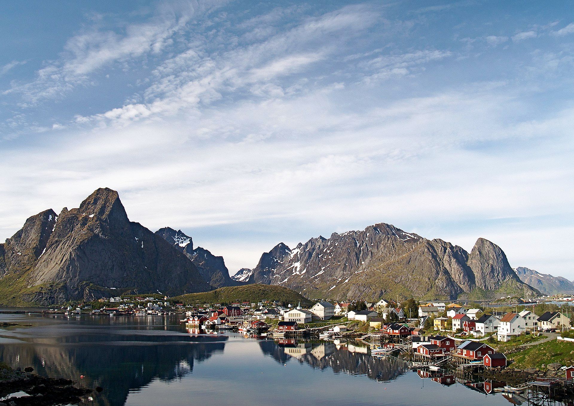
- The red rorbuer at Hamnøy with Festvågtind behind, from the bridge. The aurora is possible from roughly September to April and the midnight sun from late May to mid-July, so the two headline images require opposite trips.
Times and requirements are approximate and change with season, weather, and local rules — confirm permits, fares, and schedules with operators before you travel.
Natural riches of the area
- Ancient glacier-sculpted granite and gneiss peaks
- One of the world's richest cod fisheries (skrei)
- White-sand Arctic beaches and clear coastal waters
- Seabird colonies, sea eagles, and orca/whale-rich seas
Local food
- Stockfish (tørrfisk)
- Cod air-dried on wooden racks for centuries — Lofoten's signature export and dish.
- Fresh skrei cod
- The winter-spawning Arctic cod, poached with liver and roe in the traditional way.
- Cloudberries
- Amber Arctic berries gathered in late summer, served with cream.
Lofoten looks almost invented: a wall of sharp granite peaks rising straight out of the Norwegian Sea, with white-sand beaches and turquoise coves tucked beneath them, and clusters of red cabins on stilts over the water. The mountains are some of Earth’s oldest rock, ground to serrated ridges by Ice Age glaciers, and the contrast between their severity and the soft beaches at their feet is what makes the islands so striking.
For all its Arctic drama, Lofoten is surprisingly liveable, thanks to the Gulf Stream that keeps its winters mild. That warmth, and the rich cod fishery offshore, built a thousand-year culture around stockfish — cod air-dried on wooden racks and traded across Europe. Come in summer for the midnight sun and hiking, or in the dark months for the aurora over the peaks; either way, few coastlines on the planet are this concentrated in beauty.
Lofoten Islands: common questions
How do you get to Lofoten Islands?
From Bodø or Svolvær, Norway: Fly Oslo → Bodø — roughly 1h30 — then fly on to Svolvær or Leknes, about 25–30 minutes; Or take the car ferry Bodø → Moskenes — roughly 3h–4h; Drive the E10 along the island chain — Svolvær to Å is about 2h30–3h without stops. Total travel time: Half a day from Oslo.
When is the best time to visit Lofoten Islands?
June to August for the midnight sun, hiking, and mild weather; September to March for northern lights (and dramatic, colder seas).
How long should you spend at Lofoten Islands?
Five days to a week, given the weather. Total travel time: Half a day from Oslo.
What should you bring to Lofoten Islands?
Proper waterproofs and windproofs, because Lofoten weather changes hourly and a clear morning means nothing about the afternoon Boots with real grip for wet rock and the stone Sherpa stairs, which are steep, exposed and slick when wet Winter tyres and the confidence to use them if you drive between roughly November and April A headtorch and an eye mask, depending on season — the polar night and the midnight sun each cause their own problems Booked accommodation well ahead, since the rorbuer cabins in Reine and Hamnøy sell out months in advance in summer
Do you need a permit or guide for Lofoten Islands?
No permits, and Norway's right to roam allows walking and wild camping on uncultivated land. That right has come under pressure here from sheer visitor numbers, and several municipalities have introduced local restrictions on camping and parking at the popular spots — check the current local rules rather than assuming the general rule applies everywhere. The Reinebringen stairs close in ice and after rockfall; check trail status locally.
Is Lofoten Islands crowded, and what are conditions like?
Concentrated at a handful of photogenic villages and viewpoints in summer. The rest of the archipelago stays quiet. Wet, windy and dramatic. Mild for the latitude thanks to the Gulf Stream, but rarely calm. Facilities: Good — cabins, restaurants, fuel and shops along the E10. Limited outside the villages.
Added Updated
More wonders to explore