Kornati Islands
📍 Šibenik-Knin / Zadar County, Adriatic Sea, Croatia
A stark, sun-bleached archipelago of some 89 islands, islets, and reefs — the densest island cluster in the Adriatic — whose seaward cliffs, the dramatic 'crowns', drop straight into deep blue water.
What makes it marvelous
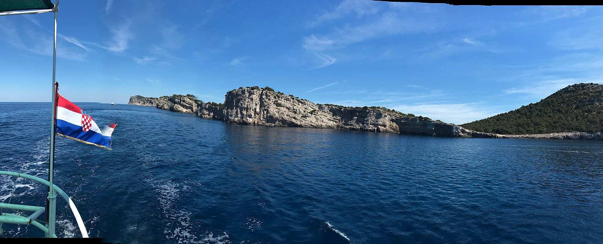
The Kornati form a national park covering about 89 of the roughly 150 islands and rocks in the wider archipelago, packed into a small stretch of the central Dalmatian coast — the densest island group in the Adriatic. They are almost bare: pale karst limestone, stripped of trees by centuries of grazing and clearance, scattered with drystone walls and a few shepherds' cottages. Their most dramatic feature is the crowns (krune) — high cliffs on the seaward, southwestern side where the land has been sheared along a great fault and plunges vertically into and below the sea, some faces dropping many tens of metres. The archipelago is the drowned crest of a limestone ridge: rising sea level after the last ice age flooded the valleys between its folds, leaving only the ridge tops standing above water. Established as a national park in 1980, the Kornati protect both this austere island scenery and the rich marine life of the surrounding sea.
Why visit
Sailing among the Kornati is like drifting through a maze of pale, treeless islands under an enormous sky — silent, elemental, and utterly unlike the busy Dalmatian coast. The crowns seen from the water are magnificent, the swimming is superb, and a meal of fresh-grilled fish at a lonely island konoba, reachable only by boat, is a quintessential Adriatic experience.
Still deciding?
Kornati Islands comes up most often against one other place — each one weighs cost, effort, season and crowds side by side.
More views of Kornati Islands
Additional photographs of the actual site — each freely licensed, with its photographer and licence credited.
What to know before you go
🗓️ Best time
Late spring to early autumn (May–September) for warm, settled seas and the full sailing season; there is little shade or shelter, and the islands are windswept and bare in the cooler months.
🧭 Getting there & access
By boat only — chartered yacht, or a day excursion from Zadar, Šibenik, Murter, or nearby towns. There are no permanent settlements, roads, or ferries into the park.
Good to know
- Come by boat — day trips from Murter, Zadar, or Šibenik are the easiest way in.
- Bring everything you need; the islands have almost no shops, water, or shade.
- View the crowns from the sea on the southwest side, where the cliffs are highest.
Plan your visit
Easy🧭 Getting there
From Zadar (ZAD) or Split (SPU), via Murter
- Fly to Zadar or Split
- Drive to Murter, Zadar, or Sibenik and join a boat excursion or charter — 1–1.5 hours
- Total travel
- Around 2 hours to a departure port, plus the boat
- Time at site
- A full day by excursion; several days by sailboat
- Access
- The park is reachable only by boat, and entry requires a park ticket, usually bundled into an excursion or charter fee. There are no shops, roads, or freshwater sources on the islands, so everything must be brought in.
🎒 What to bring & consider
- Sun protection, hats, and plenty of water — there is virtually no shade
- Everything you will eat and drink, unless your trip includes an island konoba
- Swim gear and shoes for rocky shorelines and swimming stops
- Cash for the park ticket and remote island restaurants
- Sea-sickness precautions if you are prone to it
👁️ What to expect
- Crowds
- Popular anchorages and konobas fill in peak summer; much of the archipelago stays empty.
- Conditions
- Open-water sailing and swimming; bare, exposed islands with strong sun and wind.
- Facilities
- A handful of seasonal island konobas; otherwise nothing — no shops, water, or towns.
- The view
- The towering crowns are best shot from the sea in raking morning or evening light.
Times and requirements are approximate and change with season, weather, and local rules — confirm permits, fares, and schedules with operators before you travel.
Natural riches of the area
- A dense archipelago of bare karst limestone islands
- The 'crowns' — sheer seaward cliffs along a tectonic fault
- Clear, life-rich Adriatic waters and reefs
- Drystone walls and traditional shepherds' landscapes
Local food
- Grilled fish
- The day's catch cooked simply over the coals at island konobas.
- Lamb from under the peka
- Meat and vegetables slow-baked under a bell-shaped lid buried in embers.
- Local olive oil
- Pressed from the hardy olives that survive on these arid islands.
The Kornati are the Adriatic stripped to its essentials. Packed into a short stretch of the central Dalmatian coast lies the sea’s densest island cluster — a national park of some 89 islands, islets, and reefs, pale as bone and almost entirely bare. Centuries of grazing and clearance left them treeless: karst limestone scattered with drystone walls, the odd shepherd’s cottage, and little else. The effect is stark, silent, and strangely beautiful.
Their signature is the crowns — the krune. Along the islands’ southwestern, seaward edge the land has been sheared off by a great fault and drops in sheer cliffs straight into deep water, some faces falling many tens of metres. Seen from a boat, these ramparts are the archipelago’s most dramatic sight, and they are the reason the Kornati were made a national park in 1980: to protect both the austere island scenery and the abundant life of the surrounding sea.
There is no ferry, no road, no village here — you come by boat or not at all. That is precisely the appeal. Sailing the maze of channels, swimming off empty islets, and tying up at a lonely konoba for grilled fish and island wine is one of the great Adriatic experiences: a landscape a famous visitor once described as made ‘from tears, stars and breath’, best met on its own quiet, elemental terms.
Kornati Islands: common questions
How do you get to Kornati Islands?
From Zadar (ZAD) or Split (SPU), via Murter: Fly to Zadar or Split; Drive to Murter, Zadar, or Sibenik and join a boat excursion or charter — 1–1.5 hours. Total travel time: Around 2 hours to a departure port, plus the boat.
When is the best time to visit Kornati Islands?
Late spring to early autumn (May–September) for warm, settled seas and the full sailing season; there is little shade or shelter, and the islands are windswept and bare in the cooler months.
How long should you spend at Kornati Islands?
A full day by excursion; several days by sailboat. Total travel time: Around 2 hours to a departure port, plus the boat.
What should you bring to Kornati Islands?
Sun protection, hats, and plenty of water — there is virtually no shade Everything you will eat and drink, unless your trip includes an island konoba Swim gear and shoes for rocky shorelines and swimming stops Cash for the park ticket and remote island restaurants Sea-sickness precautions if you are prone to it
Do you need a permit or guide for Kornati Islands?
The park is reachable only by boat, and entry requires a park ticket, usually bundled into an excursion or charter fee. There are no shops, roads, or freshwater sources on the islands, so everything must be brought in.
Is Kornati Islands crowded, and what are conditions like?
Popular anchorages and konobas fill in peak summer; much of the archipelago stays empty. Open-water sailing and swimming; bare, exposed islands with strong sun and wind. Facilities: A handful of seasonal island konobas; otherwise nothing — no shops, water, or towns.
Added Updated
More wonders to explore