Kebnekaise
📍 Kiruna Municipality, Norrbotten, Swedish Lapland
Sweden's highest mountain, whose summit changed places because the old one is made of ice — the glacier-capped south peak has melted below the bare rock of the north peak, and researchers measure the difference every summer.
What makes it marvelous
Kebnekaise has two summits, and which one is highest is not a settled question of geography but an annual measurement. The north peak is exposed bedrock at a fixed 2,096.8 metres. The south peak is the top of a small summit glacier, and it has been losing height for decades — traditionally quoted at over 2,110 metres, it fell below the north peak in 2019 and was measured at 2,088.4 metres in 2025, a metre and a half lower than the year before. Every late summer, glaciologists from Stockholm University's Tarfala Research Station climb it with differential GPS to catch the ice at its thinnest before the new snow arrives. The same valley holds Storglaciären, which carries the longest continuous glacier mass-balance record anywhere in the world, running unbroken since 1946. Kebnekaise is one of the few mountains on Earth where the reason its elevation keeps changing is documented year by year.
Why visit
It is the highest ground in Sweden and a genuine Arctic massif — 150 kilometres north of the Arctic Circle, heavily glaciated, ringed by U-shaped valleys — yet the standard western route is a long hike rather than a climb. In midsummer the sun does not set, so an ascent can run through what should be the middle of the night with the whole of Lapland lit sideways.
What to know before you go
🗓️ Best time
Late June to early September is the walking season, when the western route is largely snow-free and the mountain station is open. Midsummer brings the midnight sun; late August adds autumn colour on the tundra and fewer people. Outside this window Kebnekaise is a winter mountaineering and ski-touring objective.
🧭 Getting there & access
Fly or take the night train to Kiruna, then road transfer to the trailhead at Nikkaluokta. From there it is roughly 19 km on foot to Kebnekaise mountain station, with a boat shortening about 5 km of it in season. The western route to the south summit is about 9 km from the station and is mostly hiking, with one short exposed scramble; the eastern route crosses glaciers and needs mountaineering skills and equipment.
Good to know
- Take the western route unless you are equipped and experienced for glacier travel — the eastern route is a serious step up.
- Book the mountain station well ahead; it is the only real accommodation at the foot of the climb.
- The summit glacier is small but steep-sided, and people have slid off the eastern drop. Traction and caution matter more than fitness at the top.
- Weather here turns fast. Carry full shell layers even on a forecast blue-sky day in July.
Plan your visit
Strenuous🧭 Getting there
From Kiruna, Sweden
- Fly to Kiruna, or take the overnight train from Stockholm
- Transfer by road to the trailhead at Nikkaluokta
- Walk roughly 19 km in to Kebnekaise mountain station
- Climb the south summit by the western route and return the same day
- Total travel
- A day from Stockholm to the mountain station
- Time at site
- 3 days — in, summit day, out
- Access
- No permit is needed and the mountain is freely accessible, but the mountain station books out in season and should be reserved well ahead. Guides work from the station for the eastern glacier route and for winter ascents. Nikkaluokta transfers run to a timetable rather than on demand.
🎒 What to bring & consider
- Full shell and insulation layers — Arctic weather regardless of the month
- Boots suited to long scree and boulder walking
- Traction for the summit glacier, which is icy even in summer
- Food for the walk in; there is nothing between Nikkaluokta and the station
- An eye mask if you are sleeping under the midnight sun
👁️ What to expect
- Crowds
- Busy on the western route in July and at the mountain station. The valleys either side thin out quickly.
- Conditions
- Long approach on marked trail, then steep boulder and scree. Cold, exposed and windy above 1,500 m.
- Facilities
- A full mountain station with beds, meals and a shop at the foot of the climb; a small cabin on the summit plateau. Nothing else.
- The view
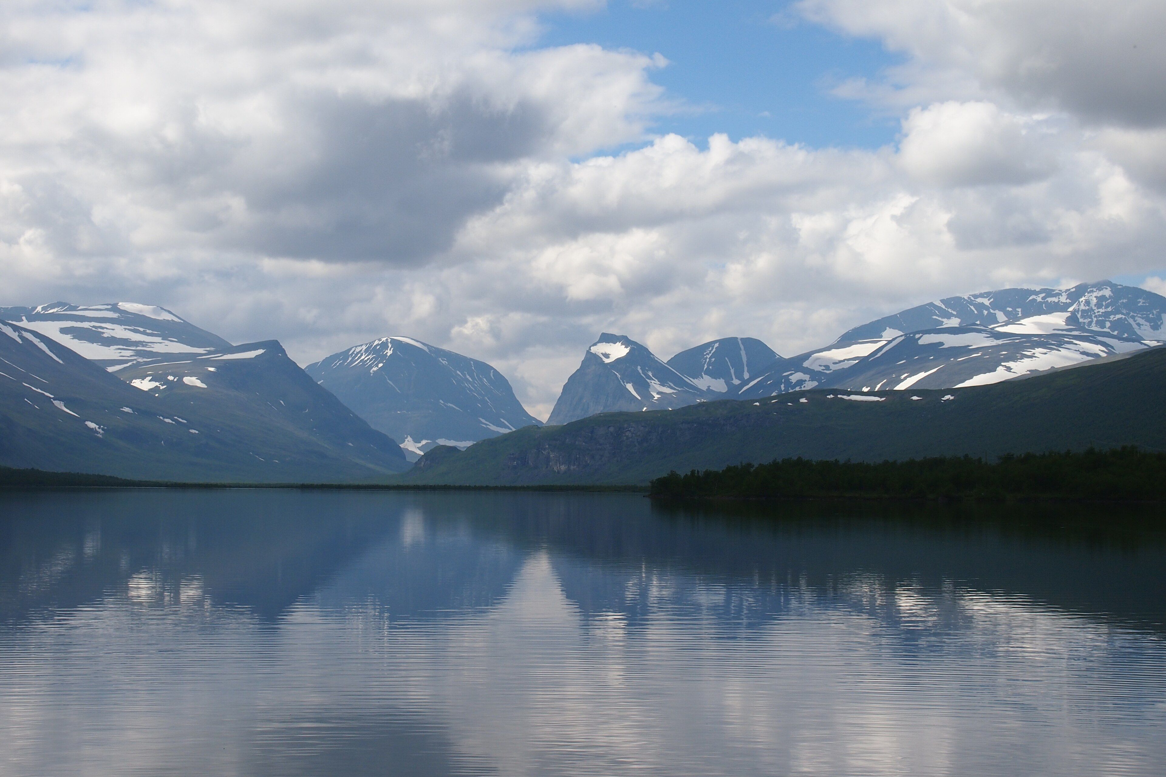
- The massif reflected in Ládtjojávri on the walk in, snow still lying in the corries, before the cloud comes down over the summits.
Times and requirements are approximate and change with season, weather, and local rules — confirm permits, fares, and schedules with operators before you travel.
Natural riches of the area
- Sweden's highest ground — north peak 2,096.8 m of bare rock, south peak a shrinking summit glacier
- A heavily glaciated massif including Storglaciären, Isfallsglaciären and Rabots glaciär
- The world's longest continuous glacier mass-balance record, running since 1946
- Deep alpine permafrost, several hundred metres thick beneath the massif
- Glacially carved valleys — Ladtjovagge, Tjäktjavagge and Vistasvagge — radiating from the range
Local food
- Renskav
- Thinly sliced reindeer, fried and served with lingonberries — the staple meat of Sápmi.
- Cloudberries
- Hjortron, gathered from the mires in late summer and eaten with cream or cheese.
- Arctic char
- Fished from the cold lakes and rivers of Lapland, usually cured or smoked.
- Gáhkku
- A soft Sámi flatbread cooked on a griddle, eaten with butter and cured meat.
Most countries know how tall their highest mountain is. Sweden has to check.
Kebnekaise has two summits about a kilometre apart. The northern one is bare rock and sits at a fixed 2,096.8 metres. The southern one is the top of a small glacier resting on a rocky plateau, and glaciers do not hold still. For as long as anyone had been measuring, the ice-capped south peak was the higher of the two and therefore the highest point in Sweden — quoted at 2,120 metres in the oldest surveys, then 2,117, then 2,111. In 2019 it dropped below the north peak. In 2025 it measured 2,088.4 metres, a metre and a half down on the previous year.
That number exists because someone goes and gets it. Every year at the end of summer, when the ice is at its thinnest and before the new snow starts, glaciologists from Stockholm University’s Tarfala Research Station climb the south peak and fix its height by differential GPS. The station sits in the valley on the eastern side of the massif, and it has been doing this kind of work for a very long time: Storglaciären, one of the glaciers below it, carries the longest continuous mass-balance record of any glacier in the world, unbroken since 1946.
The mountain itself is worth the walk regardless of which end of it is winning. It stands about 150 kilometres north of the Arctic Circle, glaciers on three sides, glacially carved valleys running away from it in every direction, and permafrost several hundred metres deep beneath the rock. The western route from the mountain station is a long day’s hiking with one short exposed section rather than a climb — which makes Kebnekaise unusually reachable for a mountain of its character. Go in midsummer and the sun never sets, so you can start the ascent at what the clock insists is midnight and watch the light move sideways across Lapland instead of going out.
Kebnekaise: common questions
How do you get to Kebnekaise?
From Kiruna, Sweden: Fly to Kiruna, or take the overnight train from Stockholm; Transfer by road to the trailhead at Nikkaluokta; Walk roughly 19 km in to Kebnekaise mountain station; Climb the south summit by the western route and return the same day. Total travel time: A day from Stockholm to the mountain station.
When is the best time to visit Kebnekaise?
Late June to early September is the walking season, when the western route is largely snow-free and the mountain station is open. Midsummer brings the midnight sun; late August adds autumn colour on the tundra and fewer people. Outside this window Kebnekaise is a winter mountaineering and ski-touring objective.
How long should you spend at Kebnekaise?
3 days — in, summit day, out. Total travel time: A day from Stockholm to the mountain station.
What should you bring to Kebnekaise?
Full shell and insulation layers — Arctic weather regardless of the month Boots suited to long scree and boulder walking Traction for the summit glacier, which is icy even in summer Food for the walk in; there is nothing between Nikkaluokta and the station An eye mask if you are sleeping under the midnight sun
Do you need a permit or guide for Kebnekaise?
No permit is needed and the mountain is freely accessible, but the mountain station books out in season and should be reserved well ahead. Guides work from the station for the eastern glacier route and for winter ascents. Nikkaluokta transfers run to a timetable rather than on demand.
Is Kebnekaise crowded, and what are conditions like?
Busy on the western route in July and at the mountain station. The valleys either side thin out quickly. Long approach on marked trail, then steep boulder and scree. Cold, exposed and windy above 1,500 m. Facilities: A full mountain station with beds, meals and a shop at the foot of the climb; a small cabin on the summit plateau. Nothing else.
Added
More wonders to explore