Joshua Tree National Park
📍 Southern California, USA, between Twentynine Palms and Interstate 10, about 140 miles east of Los Angeles
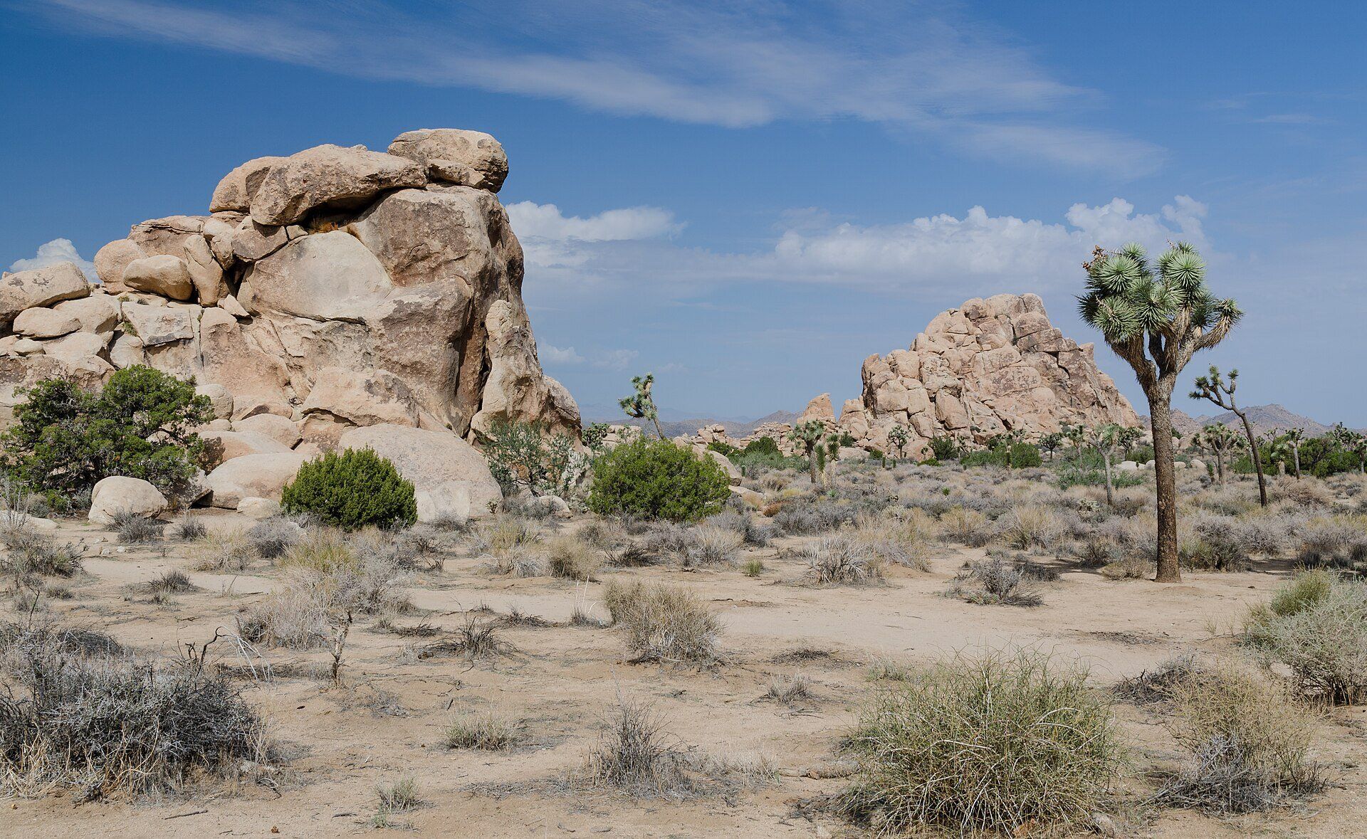
Where two deserts meet: shaggy Joshua trees and piles of rounded monzogranite boulders spread across nearly 800,000 acres of southern California, with dark night skies and a long drop into the lower Colorado Desert.
What makes it marvelous
Joshua Tree National Park protects a transition zone between two deserts: the higher Mojave, home of the park's namesake Joshua trees, and the lower, hotter Colorado Desert to the east. It covers 795,156 gross acres (3,218 km²), rising from 536 ft (163 m) at the southeastern boundary to 5,814 ft (1,773 m) on Quail Mountain. The famous rock piles began more than 100 million years ago as molten rock that cooled underground into monzogranite; groundwater working along its joints rounded the blocks into boulders, and flash floods later stripped away the surrounding ground. The Joshua tree itself (Yucca brevifolia), once classed as a giant lily and now placed in the agave family, can top 40 feet and depends on a single pollinator, the yucca moth.
Why visit
Scramble among boulder piles, walk through forests of Joshua trees, then stay after dark in one of America's International Dark Sky Parks.
Still deciding?
Joshua Tree National Park comes up most often against these — each one weighs cost, effort, season and crowds side by side.
What to know before you go
🗓️ Best time
Spring and autumn, when highs run about 70–85°F (21–29°C) and nights about 50°F (10°C). Winter days are cool with nights near or below freezing; summer highs approach 100°F (38°C). Weekends from October to May and spring break (March to mid-April) are the busiest times.
🧭 Getting there & access
Approach from California Highway 62 (Twentynine Palms Highway) or Interstate 10. The West Entrance is five miles south of Highway 62 at Joshua Tree Village, the North Entrance is in Twentynine Palms, and the South Entrance near Cottonwood Spring is on Interstate 10, 25 miles east of Indio. The closest airport is Palm Springs.
Good to know
- There is no water, fuel, food or lodging inside the park — fill up and stock up in the towns along Highway 62 or I-10.
- Cell reception is very limited; download an offline map before you arrive, and don't rely on GPS routing, which can send cars onto impassable backcountry roads.
- Arrive early on weekends and holidays — small trailhead lots such as Hidden Valley fill quickly.
- Ryan Mountain is a 3-mile (4.8 km) round trip with 1,050 ft (320 m) of climbing; don't attempt it in hot weather.
Plan your visit
Easy🧭 Getting there
From Palm Springs (PSP), the closest airport; or a drive of about 140 miles east from Los Angeles
- Fly into Palm Springs or drive east from Los Angeles
- Take Highway 62 to Joshua Tree Village or Twentynine Palms
- Enter at the West or North Entrance and follow Park Boulevard through the Joshua tree country
- Continue south to the Cholla Cactus Garden and exit to Interstate 10 via Cottonwood Spring
- Total travel
- Plan a full day to cross the park from Highway 62 to Interstate 10 with stops along the way
- Time at site
- One full day for the highlights; two or more to hike, climb and stay for the stars
- Access
- Three entrances — West (Joshua Tree Village), North (Twentynine Palms) and South (Cottonwood Spring, off I-10). An entrance fee applies. Short walks such as the one-mile Hidden Valley loop and the quarter-mile Cholla Cactus Garden trail start right beside the road.
🎒 What to bring & consider
- All the water you will need — none is available in the park interior
- A full fuel tank and your own food
- Sun hat, sunscreen and layers for cold desert nights
- An offline map
👁️ What to expect
- Crowds
- Around three million visitors a year; busiest on weekends from October to May, holidays and spring break.
- Conditions
- Paved roads to the main sights, then sandy trails and rock scrambles with little shade.
- Facilities
- Visitor centres near the entrances and campgrounds, but no gas stations, restaurants, shops or hotels inside the park.
- The view
- A lone Joshua tree beside a pile of golden boulders in late-afternoon light.
Times and requirements are approximate and change with season, weather, and local rules — confirm permits, fares, and schedules with operators before you travel.
Natural riches of the area
- Forests of Joshua trees (Yucca brevifolia) in the Mojave Desert half of the park
- Monzogranite boulder piles shaped by groundwater weathering and flash floods
- The Cholla Cactus Garden, dominated by teddybear cholla, in the Pinto Basin
- Five fan palm oases
- Quail Mountain, the park's high point at 5,814 ft (1,773 m)
Local food
- Date shakes
- A desert-road classic of the Coachella Valley, blended from locally grown dates.
- Mexican-Californian fare
- Burritos, tacos and enchiladas from the cafés of Joshua Tree, Twentynine Palms and Indio.
Joshua Tree is where two deserts meet. In southern California, about 140 miles east of Los Angeles, the high Mojave Desert gives way to the lower, hotter Colorado Desert, and the national park that straddles the boundary covers nearly 800,000 acres — from 536 feet at its southeastern edge to 5,814 feet on Quail Mountain.
The higher half belongs to the park’s namesake. The Joshua tree is no true tree: once classed as a giant lily, it is now placed in the agave family, grows only half an inch to three inches a year after an early spurt, and can stretch more than 40 feet high. Every seed depends on one partner, the yucca moth, which pollinates the flowers as it lays its eggs. Around the trees rise the park’s other signature — heaps of rounded monzogranite boulders. They began more than 100 million years ago as molten rock cooling underground; groundwater seeping along cracks rotted the blocks into rounded cores, and once the climate dried, flash floods washed away the soil and left the boulders stacked in the open.
Lower down, the Pinto Basin holds the Cholla Cactus Garden, a dense stand of teddybear cholla along a quarter-mile trail, and five fan palm oases are scattered through the park. Joshua Tree became a national monument in 1936 and a national park in 1994, and in 2017 it was recognised as an International Dark Sky Park. Come in spring or autumn, carry all your water — there is none in the park’s interior — and stay after sunset.
Joshua Tree National Park: common questions
How do you get to Joshua Tree National Park?
From Palm Springs (PSP), the closest airport; or a drive of about 140 miles east from Los Angeles: Fly into Palm Springs or drive east from Los Angeles; Take Highway 62 to Joshua Tree Village or Twentynine Palms; Enter at the West or North Entrance and follow Park Boulevard through the Joshua tree country; Continue south to the Cholla Cactus Garden and exit to Interstate 10 via Cottonwood Spring. Total travel time: Plan a full day to cross the park from Highway 62 to Interstate 10 with stops along the way.
When is the best time to visit Joshua Tree National Park?
Spring and autumn, when highs run about 70–85°F (21–29°C) and nights about 50°F (10°C). Winter days are cool with nights near or below freezing; summer highs approach 100°F (38°C). Weekends from October to May and spring break (March to mid-April) are the busiest times.
How long should you spend at Joshua Tree National Park?
One full day for the highlights; two or more to hike, climb and stay for the stars. Total travel time: Plan a full day to cross the park from Highway 62 to Interstate 10 with stops along the way.
What should you bring to Joshua Tree National Park?
All the water you will need — none is available in the park interior A full fuel tank and your own food Sun hat, sunscreen and layers for cold desert nights An offline map
Do you need a permit or guide for Joshua Tree National Park?
Three entrances — West (Joshua Tree Village), North (Twentynine Palms) and South (Cottonwood Spring, off I-10). An entrance fee applies. Short walks such as the one-mile Hidden Valley loop and the quarter-mile Cholla Cactus Garden trail start right beside the road.
Is Joshua Tree National Park crowded, and what are conditions like?
Around three million visitors a year; busiest on weekends from October to May, holidays and spring break. Paved roads to the main sights, then sandy trails and rock scrambles with little shade. Facilities: Visitor centres near the entrances and campgrounds, but no gas stations, restaurants, shops or hotels inside the park.
Added
More wonders to explore