White Sands
📍 Tularosa Basin, near Alamogordo, New Mexico, USA
The largest gypsum dunefield on Earth — 710 km² of brilliant white dunes in New Mexico's Tularosa Basin, protected in White Sands National Park and surrounded by a missile range.
What makes it marvelous
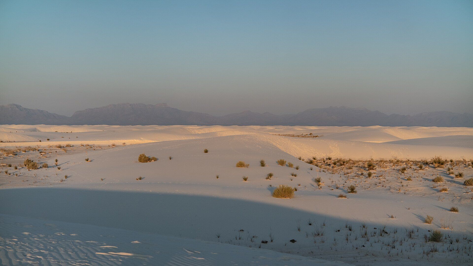
White Sands National Park protects the southern 41% of a 710 km² field of white sand dunes made of gypsum crystals — the largest gypsum dunefield on Earth. The dunes stand up to 18 metres high on a sand sheet about 9 metres deep, holding some 4.1 billion tonnes of gypsum. Around 12,000 years ago the basin held large lakes; as the climate warmed and dried, the lakes evaporated and left selenite crystals, which the wind broke up and carried east as sand — a process that still goes on. Several animals here have evolved white or pale colouring, and at least 45 species live nowhere else, 40 of them moths.
Why visit
Walk, sled or sit on dunes as white as snow — and watch the sand turn pink and blue as the sun goes down behind the San Andres Mountains.
Still deciding?
White Sands comes up most often against one other place — each one weighs cost, effort, season and crowds side by side.
What to know before you go
🗓️ Best time
Spring and autumn are mild; summer days are very hot and winter nights cold. Sunset and the hour after are the best time on the dunes.
🧭 Getting there & access
From Alamogordo, about 13 miles (21 km) along US-70 to the visitor centre, then the 8-mile (13 km) Dunes Drive into the dunefield. The road can close for up to three hours during missile tests on the surrounding range.
Good to know
- Check the park's closures page before you go — missile tests can shut Dunes Drive for up to three hours.
- Fill up with fuel in Alamogordo; there is none in the park.
- Carry plenty of water and note landmarks — every dune looks the same and the white sand reflects heat and glare.
- Bring or buy a plastic sled; the steeper dune faces make the best runs.
Plan your visit
Easy🧭 Getting there
From El Paso (ELP), Texas, or Albuquerque (ABQ), New Mexico; Alamogordo is the nearest town
- Fly into El Paso or Albuquerque
- Drive to Alamogordo
- Take US-70 about 13 miles (21 km) to the visitor centre
- Drive the 8-mile (13 km) Dunes Drive into the heart of the dunefield
- Total travel
- Dunes Drive itself takes about 45 minutes round trip, plus stops
- Time at site
- Half a day; stay for sunset
- Access
- An entrance fee applies. White Sands is surrounded by White Sands Missile Range, and the park closes Dunes Drive during some military tests — for up to three hours at a time, sometimes at short notice. US-70 towards Las Cruces can close too. Check the park's closures page before setting out.
🎒 What to bring & consider
- Plenty of water — there is no shade on the dunes
- Sunglasses, hat and sunscreen for the intense glare
- A full fuel tank from Alamogordo
- A sled, if you want to slide the dunes
👁️ What to expect
- Crowds
- The most visited National Park Service site in New Mexico; the picnic areas fill at weekends, but a few minutes' walk takes you away from the road.
- Conditions
- Dunes Drive is paved for 5 miles, then hard-packed gypsum for 3. Hiking on the dunes is in soft sand with no shade.
- Facilities
- Visitor centre and gift shop at the entrance; picnic areas along Dunes Drive; no food or fuel inside the park.
- The view
- Rippled white dunes in low evening light with the San Andres Mountains on the horizon.
Times and requirements are approximate and change with season, weather, and local rules — confirm permits, fares, and schedules with operators before you travel.
Natural riches of the area
- The largest gypsum dunefield on Earth
- Dunes up to 18 m high
- At least 45 endemic species, including pale-coloured lizards and moths
- Fossilised human footprints on the old lake bed
Local food
- Green chile
- New Mexico's signature roasted chile, on burgers, stews and enchiladas.
- Sopaipillas
- Puffed fried bread, eaten with honey alongside New Mexican dishes.
White Sands looks like snow until you touch it. In New Mexico’s Tularosa Basin, a field of dunes covering about 710 km² is made not of quartz but of gypsum — the largest gypsum dunefield on Earth — and the sand stays cool and bright even under a desert sun.
It formed when the climate changed. Around 12,000 years ago the basin held large lakes, streams and grassland. As it warmed, rain and snowmelt dissolved gypsum from the surrounding mountains and carried it down into the lakes; as they dried, the gypsum crystallised as selenite, and strong winds broke the crystals up and drove them east as sand. The process continues today. The dunes reach 18 metres high on a sand sheet about 9 metres deep.
Life here has adapted to the white: several animals have pale or white colouring, and at least 45 species — 40 of them moths — live nowhere else. White Sands National Park protects the southern 41% of the dunefield; the rest lies inside White Sands Missile Range, which is why Dunes Drive sometimes closes for tests. Bring a sled, plenty of water, and stay for sunset, when the dunes turn pink and then blue.
White Sands: common questions
How do you get to White Sands?
From El Paso (ELP), Texas, or Albuquerque (ABQ), New Mexico; Alamogordo is the nearest town: Fly into El Paso or Albuquerque; Drive to Alamogordo; Take US-70 about 13 miles (21 km) to the visitor centre; Drive the 8-mile (13 km) Dunes Drive into the heart of the dunefield. Total travel time: Dunes Drive itself takes about 45 minutes round trip, plus stops.
When is the best time to visit White Sands?
Spring and autumn are mild; summer days are very hot and winter nights cold. Sunset and the hour after are the best time on the dunes.
How long should you spend at White Sands?
Half a day; stay for sunset. Total travel time: Dunes Drive itself takes about 45 minutes round trip, plus stops.
What should you bring to White Sands?
Plenty of water — there is no shade on the dunes Sunglasses, hat and sunscreen for the intense glare A full fuel tank from Alamogordo A sled, if you want to slide the dunes
Do you need a permit or guide for White Sands?
An entrance fee applies. White Sands is surrounded by White Sands Missile Range, and the park closes Dunes Drive during some military tests — for up to three hours at a time, sometimes at short notice. US-70 towards Las Cruces can close too. Check the park's closures page before setting out.
Is White Sands crowded, and what are conditions like?
The most visited National Park Service site in New Mexico; the picnic areas fill at weekends, but a few minutes' walk takes you away from the road. Dunes Drive is paved for 5 miles, then hard-packed gypsum for 3. Hiking on the dunes is in soft sand with no shade. Facilities: Visitor centre and gift shop at the entrance; picnic areas along Dunes Drive; no food or fuel inside the park.
Added
More wonders to explore