Mount Ararat
📍 Iğdır Province, Eastern Anatolia, Turkey
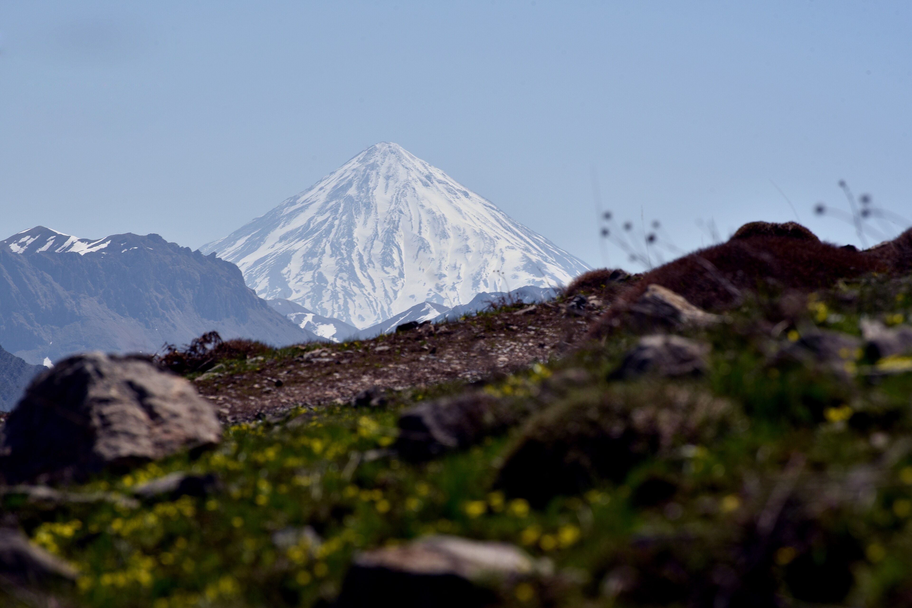
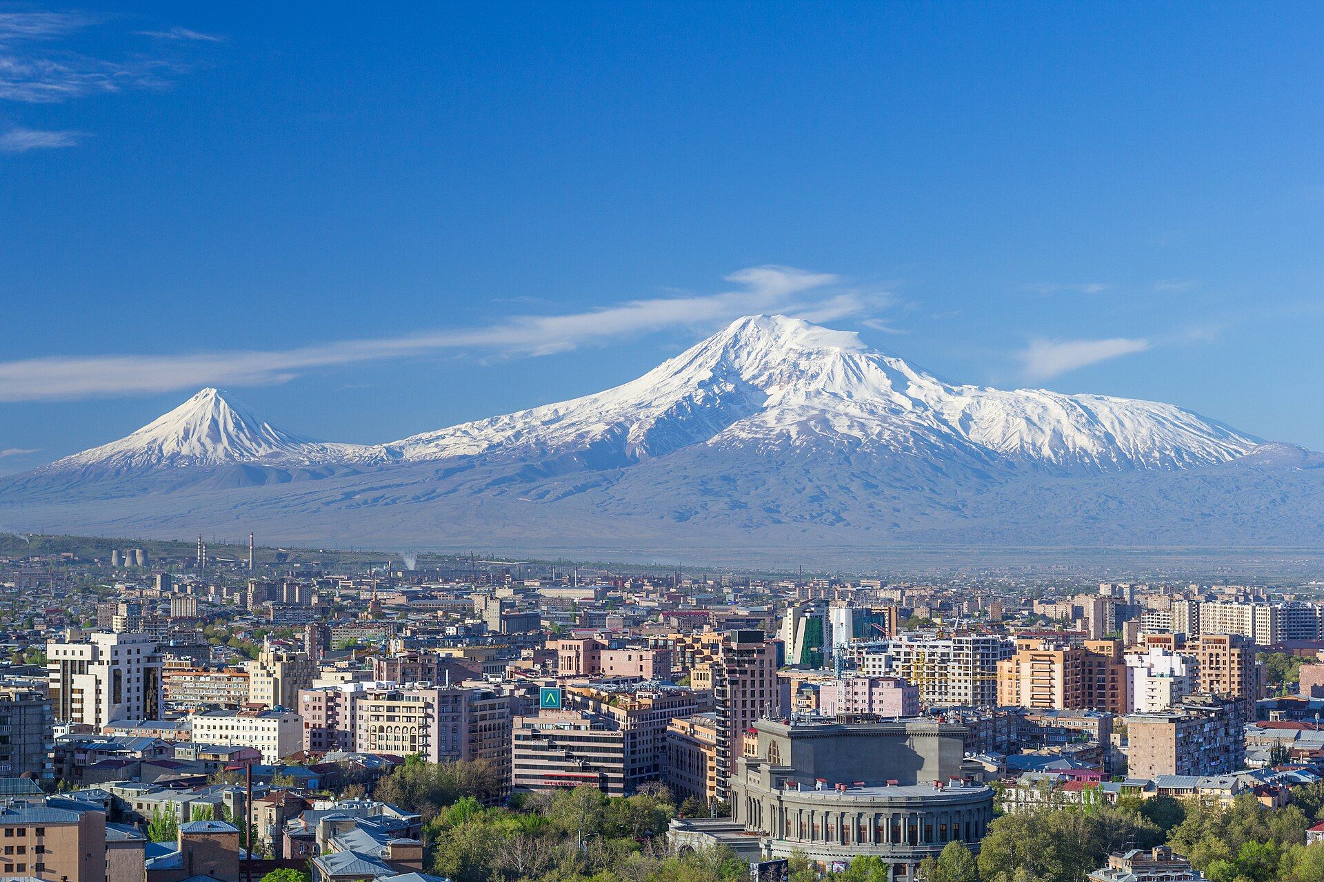
Turkey's highest peak — a snow-capped dormant volcano of two joined cones rising in near-perfect isolation above the plains of the Armenian highlands, its ice cap visible a hundred kilometres away.
What makes it marvelous
Ararat is a compound stratovolcano: two cones welded together — Greater Ararat at 5,137 m and Little Ararat at 3,896 m — built by successive eruptions along the collision zone where the Arabian and Eurasian plates grind together. Because it stands almost alone above flat surrounding plains, its snow-and-ice cap floats free of any neighbouring range, giving it an unusually clean, solitary silhouette. Its last recorded eruption was in 1840, when an earthquake and landslide destroyed villages on its flanks; it is now classed as dormant. Greater Ararat carries the only sizeable glacier system in Turkey, a small ice cap on its summit dome that has retreated sharply over the last century.
Why visit
Few mountains dominate a landscape the way Ararat does — an immense white cone lifting straight out of the plain, visible for a hundred kilometres and utterly commanding at dawn and dusk. Reaching the summit is a genuine high-altitude ascent that draws trekkers from around the world, while the view of the massif from Doğubayazıt or across the border is a reward in itself.
More views of Mount Ararat
Additional photographs of the actual site — each freely licensed, with its photographer and licence credited.
What to know before you go
🗓️ Best time
Summer (July–September) for the climbing season, when the weather is most settled and the snow line highest; the peak keeps snow year-round and winter is severe.
🧭 Getting there & access
The staging town is Doğubayazıt in Iğdır/Ağrı province, reached from Iğdır or Van. Climbing Ararat requires a permit and, in practice, a licensed guide; regulations change, so arrange both through a reputable local operator well ahead.
Good to know
- Climbing requires a government permit and a licensed guide — book through an established operator.
- Allow days to acclimatise; the summit is above 5,000 m and altitude is the main hazard.
- For the view alone, Doğubayazıt and the Ishak Pasha Palace give superb vantage points without a climb.
Plan your visit
Expedition🧭 Getting there
From Igdir (IGD) or Van (VAN), staging in Dogubayazit
- Fly Istanbul or Ankara → Igdir or Van — roughly 2 hours
- Road to Dogubayazit, the climbing base — about 1–2 hours
- Total travel
- A long half-day from Istanbul to base
- Time at site
- A day for the viewpoints; 3–5 days for a guided summit attempt
- Access
- The mountain sits in a sensitive border zone. A permit is mandatory to climb and is normally arranged, together with a licensed guide, by a local expedition operator — do not attempt it independently. Rules and closures shift with the security situation, so confirm current requirements before you travel.
🎒 What to bring & consider
- Full high-altitude gear — crampons, ice axe and a four-season layering system, even in summer
- Several days built in for acclimatisation above 3,000 m
- A licensed guide and permit arranged in advance, not on arrival
- Strong sun and wind protection for the exposed upper slopes
- Cash for the remote east, where cards are little use
👁️ What to expect
- Crowds
- The summit sees a steady trickle of international climbers in season; the viewpoints below are quiet.
- Conditions
- A serious snow-and-scree ascent with real altitude. Weather on the cap changes fast.
- Facilities
- Basic in Dogubayazit — guesthouses and outfitters. Nothing on the mountain but camps.
- The view
- The clean floating-cone image needs clear air; Ararat often wears cloud, so allow spare days.
Times and requirements are approximate and change with season, weather, and local rules — confirm permits, fares, and schedules with operators before you travel.
Natural riches of the area
- A twin-coned dormant stratovolcano capped by permanent snow and ice
- A small summit ice cap and glaciers — a rarity at this latitude
- Alpine meadows and pastures grazed by highland communities
- A solitary massif rising above the Aras river plains
Local food
- Abdigör köftesi
- A labour-intensive meatball speciality of the Iğdır–Ağrı region, pounded until springy.
- Otlu peynir
- Eastern Anatolian herbed cheese, studded with wild mountain herbs.
- Tandır bread
- Flatbread baked against the wall of a clay tandır oven.
Mount Ararat rises in a way few mountains do — not as the high point of a crowded range, but as a single vast cone lifting straight out of the plains of easternmost Turkey. Its permanent cap of snow and ice can be seen from a hundred kilometres away, and at dawn the whole massif turns pink and gold above the flat brown country around it.
Geologically it is a compound volcano, two cones fused into one: Greater Ararat, at 5,137 metres the highest point in Turkey, and the sharper spike of Little Ararat beside it. Both were built by eruptions along the seam where the Arabian and Eurasian plates collide. The last eruption, in 1840, was accompanied by an earthquake and landslide that swept away villages on the northern flank; today the mountain sleeps.
That isolation is measurable. Ararat has a topographic prominence of roughly 3,600 metres — the drop to the lowest contour connecting it to any higher ground — which puts it among the most prominent peaks anywhere on Earth, and explains why it reads as a mountain standing entirely on its own. For visitors, it offers two very different experiences: a demanding, permit-and-guide high-altitude climb to the snow-capped summit, or simply standing on the plain at Doğubayazıt and watching one of the world’s great mountains hold up the sky.
Mount Ararat: common questions
How do you get to Mount Ararat?
From Igdir (IGD) or Van (VAN), staging in Dogubayazit: Fly Istanbul or Ankara → Igdir or Van — roughly 2 hours; Road to Dogubayazit, the climbing base — about 1–2 hours. Total travel time: A long half-day from Istanbul to base.
When is the best time to visit Mount Ararat?
Summer (July–September) for the climbing season, when the weather is most settled and the snow line highest; the peak keeps snow year-round and winter is severe.
How long should you spend at Mount Ararat?
A day for the viewpoints; 3–5 days for a guided summit attempt. Total travel time: A long half-day from Istanbul to base.
What should you bring to Mount Ararat?
Full high-altitude gear — crampons, ice axe and a four-season layering system, even in summer Several days built in for acclimatisation above 3,000 m A licensed guide and permit arranged in advance, not on arrival Strong sun and wind protection for the exposed upper slopes Cash for the remote east, where cards are little use
Do you need a permit or guide for Mount Ararat?
The mountain sits in a sensitive border zone. A permit is mandatory to climb and is normally arranged, together with a licensed guide, by a local expedition operator — do not attempt it independently. Rules and closures shift with the security situation, so confirm current requirements before you travel.
Is Mount Ararat crowded, and what are conditions like?
The summit sees a steady trickle of international climbers in season; the viewpoints below are quiet. A serious snow-and-scree ascent with real altitude. Weather on the cap changes fast. Facilities: Basic in Dogubayazit — guesthouses and outfitters. Nothing on the mountain but camps.
Added Updated