Yushan (Jade Mountain)
📍 Yushan National Park, on the borders of Nantou, Chiayi and Kaohsiung, central Taiwan
At 3,952 metres, the main peak of Yushan is the highest point in Taiwan — the centre of a cross-shaped massif pushed up by the collision of the Philippine Sea and Eurasian plates, and a two-day climb from the Tataka trailhead with a park permit.
What makes it marvelous
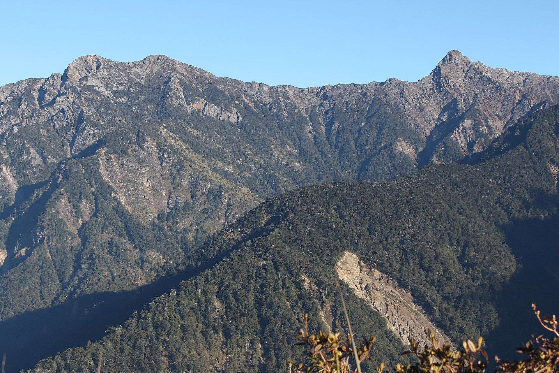
Yushan is what happens when two tectonic plates meet under a small island. The collision of the Philippine Sea Plate with the Eurasian Plate has pushed up a massif whose ridges form a rough cross — long north to south, short east to west — with the main peak at its centre at 3,952 metres. That is higher than Mount Fuji, the fact that first made the mountain famous during the Japanese colonial period. Around it, the national park holds 30 summits above 3,000 metres on the list of Taiwan's 100 Peaks, and its elevation runs from about 300 metres in the Laklak Creek valley to the summit — subtropical forest to an alpine zone with an average annual temperature of 5.9°C above 3,500 metres, all within one park. On the way up the forest changes with altitude: spruce, hemlock and fir, then Yushan juniper and rhododendron, and finally the bare gravel slopes of the main peak.
Why visit
It is the summit of an island that rises almost four kilometres out of a subtropical sea, and the standard route makes that reachable for a fit hiker in two days. The walk climbs through the whole sequence of Taiwan's mountain forests to a stony top where, on a clear morning, the rest of the Central Range spreads out below — the Yushan massif is called the ridge of Taiwan for a reason.
What to know before you go
🗓️ Best time
October to December is the most reliable window: the park's driest months are November to January, after the typhoons and thunderstorms of June to September and before winter snow. The snow season runs from December to April, though snowfall days are few; snow and ice on the summit route need winter gear. May and early June bring monsoon rain.
🧭 Getting there & access
The main peak route starts at the Tataka Trailhead, where the Alishan road (Chiayi side) and the road up from Shuili (Nantou side) meet. Both a national park entry permit and a restricted mountain area permit are required and must be applied for in advance; the park's online system handles the application, and Paiyun Lodge, 8.5 km and about four hours up from the trailhead, is the usual overnight before a pre-dawn summit push.
Good to know
- Apply for the park entry permit and the restricted mountain area permit well ahead — you cannot simply turn up at the trailhead.
- Check the park's trail-status page before you go; sections close after typhoons, landslides and heavy snow.
- Plan on two days: Tataka to Paiyun Lodge on day one, summit and descent on day two.
- Carry warm layers whatever the month — above 3,500 metres the park's average annual temperature is under 6°C.
- Rockfall and landslide sections are part of the route; keep moving through them and follow the park's safety guidance.
Plan your visit
Strenuous🧭 Getting there
From Chiayi or Shuili, central Taiwan (via Taipei or Taichung)
- Fly into Taipei
- Take the train south to Chiayi (for the Alishan road) or travel to Shuili in Nantou
- Go by road to the Tataka Trailhead
- Hike 8.5 km to Paiyun Lodge, then summit before dawn and descend
- Total travel
- A day to reach the trailhead area from Taipei
- Time at site
- Two days on the mountain for the main peak route; longer itineraries take in the outlying peaks
- Access
- A national park entry permit and a restricted mountain area permit are both required and must be applied for in advance through the park. Paiyun Lodge is the standard overnight on the main peak route. Trails close after typhoons, landslides and snow, so check the park's trail-status page close to your date.
🎒 What to bring & consider
- Both permits, applied for in advance
- Warm, windproof layers and a headtorch for the pre-dawn summit push
- Winter traction and gear if going in the December–April snow season
- Rain protection, especially from May to September
- Cash in New Taiwan dollars for transport and food in Chiayi or Shuili
👁️ What to expect
- Crowds
- The permit system caps numbers on the main peak route, so the trail is busy only around the summit at sunrise.
- Conditions
- High-altitude hiking on rocky, sometimes exposed ground, with landslide sections, fast-changing cloud and cold summit temperatures.
- Facilities
- Visitor centres at Tataka and Shuili; Paiyun Lodge on the route. Nothing beyond that on the mountain.
- The view
- The summit at first light, with the cross of ridges falling away and the Central Range rising out of the cloud to the east.
Times and requirements are approximate and change with season, weather, and local rules — confirm permits, fares, and schedules with operators before you travel.
Natural riches of the area
- Main peak at 3,952 m, the highest point in Taiwan
- A cross-shaped massif raised by the Philippine Sea–Eurasian plate collision
- 30 peaks above 3,000 m within the national park
- Altitude zones from spruce, hemlock and fir forest to Yushan juniper, rhododendron and alpine grassland
- 3,000–4,700 mm of rain a year, with snow at the top from December to April
Local food
- Alishan high-mountain oolong
- Tea grown on the misty slopes of the Alishan range just west of the trailhead.
- Chiayi turkey rice
- The best-known dish of the city most climbers pass through on the way up.
- Bunun millet dishes
- Food of the Bunun communities whose homeland covers much of the park.
At 3,952 metres, the main peak of Yushan — Jade Mountain — is the highest point in Taiwan, and it sits at the centre of a massif shaped like a rough cross: long from north to south, short from east to west. The whole block is being pushed upward by the collision of the Philippine Sea Plate with the Eurasian Plate, the same process that is lifting the marble at Taroko Gorge on the east coast. During the Japanese colonial period the mountain’s fame rested on a simple comparison: it is taller than Mount Fuji.
The national park around it holds 30 summits above 3,000 metres that are on Taiwan’s list of 100 Peaks, and an elevation range from about 300 metres in the Laklak Creek valley to the top. That range is the point of the climb. The standard main peak route starts at the Tataka Trailhead and climbs 8.5 kilometres — about four hours — to Paiyun Lodge, through spruce, hemlock and fir forest, then Yushan juniper and rhododendron, before the last pre-dawn push up the gravel slopes of the summit.
Weather decides when to go. The park gets 3,000 to 4,700 millimetres of rain a year, with monsoon rain in May and early June and typhoons and thunderstorms from June to September; November to January are the driest months. Snow can fall from December to April. A national park entry permit and a restricted mountain area permit are both required, and both have to be applied for in advance.
Sources: Yushan National Park — Topography, Climate and Yushan Peaks Trail (Yushan National Park Headquarters, checked 15 November 2026).
Yushan (Jade Mountain): common questions
How do you get to Yushan (Jade Mountain)?
From Chiayi or Shuili, central Taiwan (via Taipei or Taichung): Fly into Taipei; Take the train south to Chiayi (for the Alishan road) or travel to Shuili in Nantou; Go by road to the Tataka Trailhead; Hike 8.5 km to Paiyun Lodge, then summit before dawn and descend. Total travel time: A day to reach the trailhead area from Taipei.
When is the best time to visit Yushan (Jade Mountain)?
October to December is the most reliable window: the park's driest months are November to January, after the typhoons and thunderstorms of June to September and before winter snow. The snow season runs from December to April, though snowfall days are few; snow and ice on the summit route need winter gear. May and early June bring monsoon rain.
How long should you spend at Yushan (Jade Mountain)?
Two days on the mountain for the main peak route; longer itineraries take in the outlying peaks. Total travel time: A day to reach the trailhead area from Taipei.
What should you bring to Yushan (Jade Mountain)?
Both permits, applied for in advance Warm, windproof layers and a headtorch for the pre-dawn summit push Winter traction and gear if going in the December–April snow season Rain protection, especially from May to September Cash in New Taiwan dollars for transport and food in Chiayi or Shuili
Do you need a permit or guide for Yushan (Jade Mountain)?
A national park entry permit and a restricted mountain area permit are both required and must be applied for in advance through the park. Paiyun Lodge is the standard overnight on the main peak route. Trails close after typhoons, landslides and snow, so check the park's trail-status page close to your date.
Is Yushan (Jade Mountain) crowded, and what are conditions like?
The permit system caps numbers on the main peak route, so the trail is busy only around the summit at sunrise. High-altitude hiking on rocky, sometimes exposed ground, with landslide sections, fast-changing cloud and cold summit temperatures. Facilities: Visitor centres at Tataka and Shuili; Paiyun Lodge on the route. Nothing beyond that on the mountain.
Added
More wonders to explore
Bukhansan National Park
Northern edge of Seoul and Gyeonggi Province, South Korea
Jirisan National Park
Sobaek Mountains, spanning South Jeolla, North Jeolla and South Gyeongsang provinces, South Korea, near Gurye, Namwon and Hamyang