Taroko Gorge
📍 Taroko National Park, Hualien County, eastern Taiwan
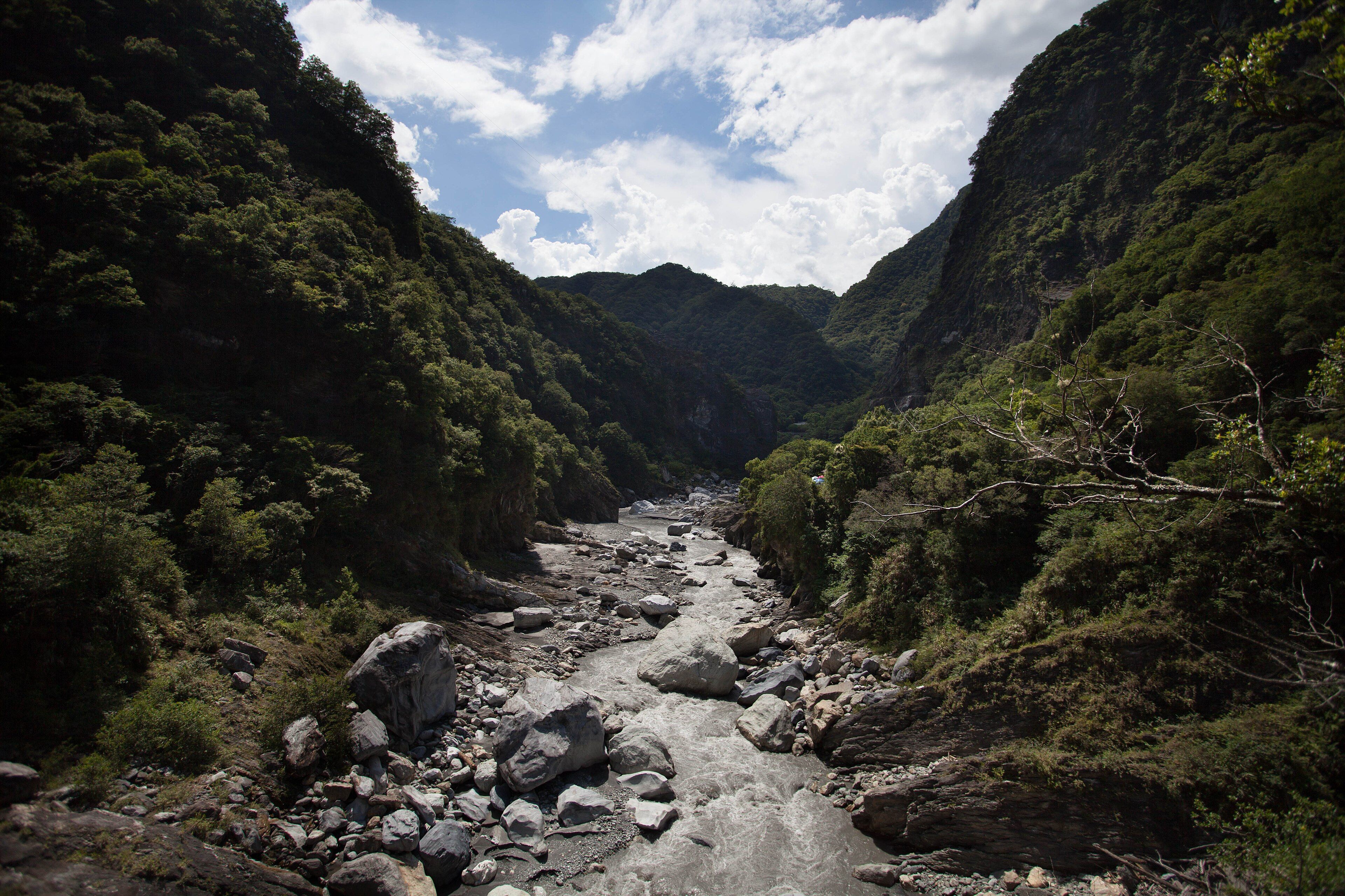
A gorge cut through solid marble on Taiwan's east coast — walls rising as much as a kilometre above the Liwu River, in one of only a handful of river canyons anywhere carved entirely through marble.
What makes it marvelous
Taroko is a race between a river and a mountain range, and neither is winning. The rock began as limestone on the floor of a subtropical sea; the collision of the Philippine Sea Plate with the Eurasian Plate buried it, cooked it into marble, and is still lifting it at several millimetres a year. The Liwu River cuts down at roughly the same rate. That balance is what produces the gorge's defining shape — a narrow slot with near-vertical walls rising up to about a kilometre, rather than the wide V a slower river would leave. The marble itself is the rarity: only a handful of river gorges anywhere are cut through it, and the polished grey-and-white banding in the canyon walls is the same stone quarried for sculpture. The canyon runs roughly 19 kilometres inland from the coast.
Why visit
Few canyons let you stand this close to the rock. The road tunnels through the cliff face for long stretches, and where it opens out the walls close overhead to a slot of sky. The marble is genuinely beautiful up close — banded, water-polished, and cool to the touch — and the contrast between subtropical vegetation clinging to the cliffs and bare white stone is unlike any other gorge.
What to know before you go
🗓️ Best time
Autumn, roughly October to December, is the most reliable — drier air, clearer skies and past the typhoon peak. Spring is pleasant. Summer is hot, humid and the height of typhoon season, when rainfall closes roads and trails at short notice.
🧭 Getting there & access
Hualien is the gateway, reached by train down the east coast from Taipei in roughly two hours, then a short drive to the park entrance. IMPORTANT: the April 2024 earthquake caused severe damage and much of the park remains closed or restricted. The visitor centre, entrance archway and several trails and viewpoints have reopened in stages, while some of the best-known trails — Shakadang, Swallow Grotto and Baiyang among them — are not expected back until the early 2030s, and Highway 8 through the gorge runs on managed release schedules rather than open access. Check the national park's current status before you travel.
Good to know
- Check the park's official status page first — what is open has changed repeatedly since 2024.
- Highway 8 operates on timed traffic releases; plan around them rather than assuming free passage.
- A helmet is issued or advised on some trails, and it is not a formality — rockfall is the main hazard here.
- Base in Hualien rather than day-tripping from Taipei; the round trip eats the daylight.
Plan your visit
Easy🧭 Getting there
From Hualien, eastern Taiwan (via Taipei)
- Fly into Taipei
- Take the east-coast train to Hualien, roughly 2 hours
- Drive or join a tour the short distance to the park entrance
- Travel the gorge road within the current traffic-release windows
- Total travel
- Half a day from Taipei to the gorge
- Time at site
- A full day; two if more trails are open when you go
- Access
- National park entry is free, but access is the constraint rather than the cost. Much of the park has been closed or restricted since the April 2024 earthquake, with some major trails not due to reopen until the early 2030s. Highway 8 through the gorge operates on managed release intervals. Verify the current position with the park authority before committing to travel.
🎒 What to bring & consider
- The park's current opening status, checked the week you travel rather than earlier
- A helmet where one is issued; rockfall is the real hazard in this gorge
- Rain protection year-round, and a plan for typhoons if travelling in summer
- Cash in New Taiwan dollars for local transport and food in Hualien
- Patience with the timed road openings, which are not negotiable
👁️ What to expect
- Crowds
- The reopened viewpoints concentrate visitors into a small number of accessible spots, so those feel busy even while the park overall is quiet.
- Conditions
- Humid and warm at the coast, cooler inland. Narrow road cut into cliffs, frequent tunnels, and active repair works.
- Facilities
- Visitor centre and toilets near the entrance; full services in Hualien. Limited inside the gorge itself.
- The view
- The marble narrows where the walls close overhead, in flat midday light that reaches the canyon floor — early and late the slot is simply dark.
Times and requirements are approximate and change with season, weather, and local rules — confirm permits, fares, and schedules with operators before you travel.
Natural riches of the area
- A gorge cut through metamorphosed marble, walls up to roughly 1,000 m high
- The Liwu River, incising at about the same rate the range is uplifting
- Active tectonic uplift of several millimetres a year
- Subtropical forest on the cliffs, rising to alpine terrain inland
Local food
- Hualien wontons
- A local speciality of the east coast city that serves as the gorge's gateway.
- Indigenous Truku dishes
- Millet, wild greens and river fish from the communities of this valley.
- Mochi
- Hualien is known across Taiwan for its glutinous rice cakes.
- High-mountain oolong
- Tea grown on the misty middle slopes of the central range inland.
Taroko is a gorge cut through marble, which is rarer than it sounds — only a handful of river canyons anywhere are carved entirely through the stuff. The rock started as limestone on a subtropical seabed. The collision of the Philippine Sea Plate with the Eurasian Plate buried it, metamorphosed it into marble, and is still lifting the whole range at several millimetres a year. The Liwu River happens to be cutting down at roughly the same rate.
That balance explains the shape. A river incising as fast as its bedrock rises has no time to widen its valley, so instead of a broad V you get a slot: near-vertical walls of banded grey and white stone climbing as much as a kilometre above a narrow floor, with the road tunnelling through the cliff face because there is nowhere else to put it. The canyon runs about 19 kilometres inland from the coast.
The same tectonics that built it also make it dangerous. The April 2024 Hualien earthquake did severe damage, and the park has reopened only in stages — several of its most famous trails, including Shakadang, Swallow Grotto and Baiyang, are not expected back until the early 2030s, and the highway through the gorge now runs on managed traffic releases. It is still worth going. It is not still worth going without checking first.
Taroko Gorge: common questions
How do you get to Taroko Gorge?
From Hualien, eastern Taiwan (via Taipei): Fly into Taipei; Take the east-coast train to Hualien, roughly 2 hours; Drive or join a tour the short distance to the park entrance; Travel the gorge road within the current traffic-release windows. Total travel time: Half a day from Taipei to the gorge.
When is the best time to visit Taroko Gorge?
Autumn, roughly October to December, is the most reliable — drier air, clearer skies and past the typhoon peak. Spring is pleasant. Summer is hot, humid and the height of typhoon season, when rainfall closes roads and trails at short notice.
How long should you spend at Taroko Gorge?
A full day; two if more trails are open when you go. Total travel time: Half a day from Taipei to the gorge.
What should you bring to Taroko Gorge?
The park's current opening status, checked the week you travel rather than earlier A helmet where one is issued; rockfall is the real hazard in this gorge Rain protection year-round, and a plan for typhoons if travelling in summer Cash in New Taiwan dollars for local transport and food in Hualien Patience with the timed road openings, which are not negotiable
Do you need a permit or guide for Taroko Gorge?
National park entry is free, but access is the constraint rather than the cost. Much of the park has been closed or restricted since the April 2024 earthquake, with some major trails not due to reopen until the early 2030s. Highway 8 through the gorge operates on managed release intervals. Verify the current position with the park authority before committing to travel.
Is Taroko Gorge crowded, and what are conditions like?
The reopened viewpoints concentrate visitors into a small number of accessible spots, so those feel busy even while the park overall is quiet. Humid and warm at the coast, cooler inland. Narrow road cut into cliffs, frequent tunnels, and active repair works. Facilities: Visitor centre and toilets near the entrance; full services in Hualien. Limited inside the gorge itself.
Added
More wonders to explore