Nxai Pan & Baines' Baobabs
📍 Nxai Pan National Park, northeastern Botswana, north of the Maun–Nata road
A fossil lake bed in the Kalahari, grassland that fills with game in the rains — and Baines' Baobabs, a cluster of ancient trees standing on the edge of a salt pan.
What makes it marvelous
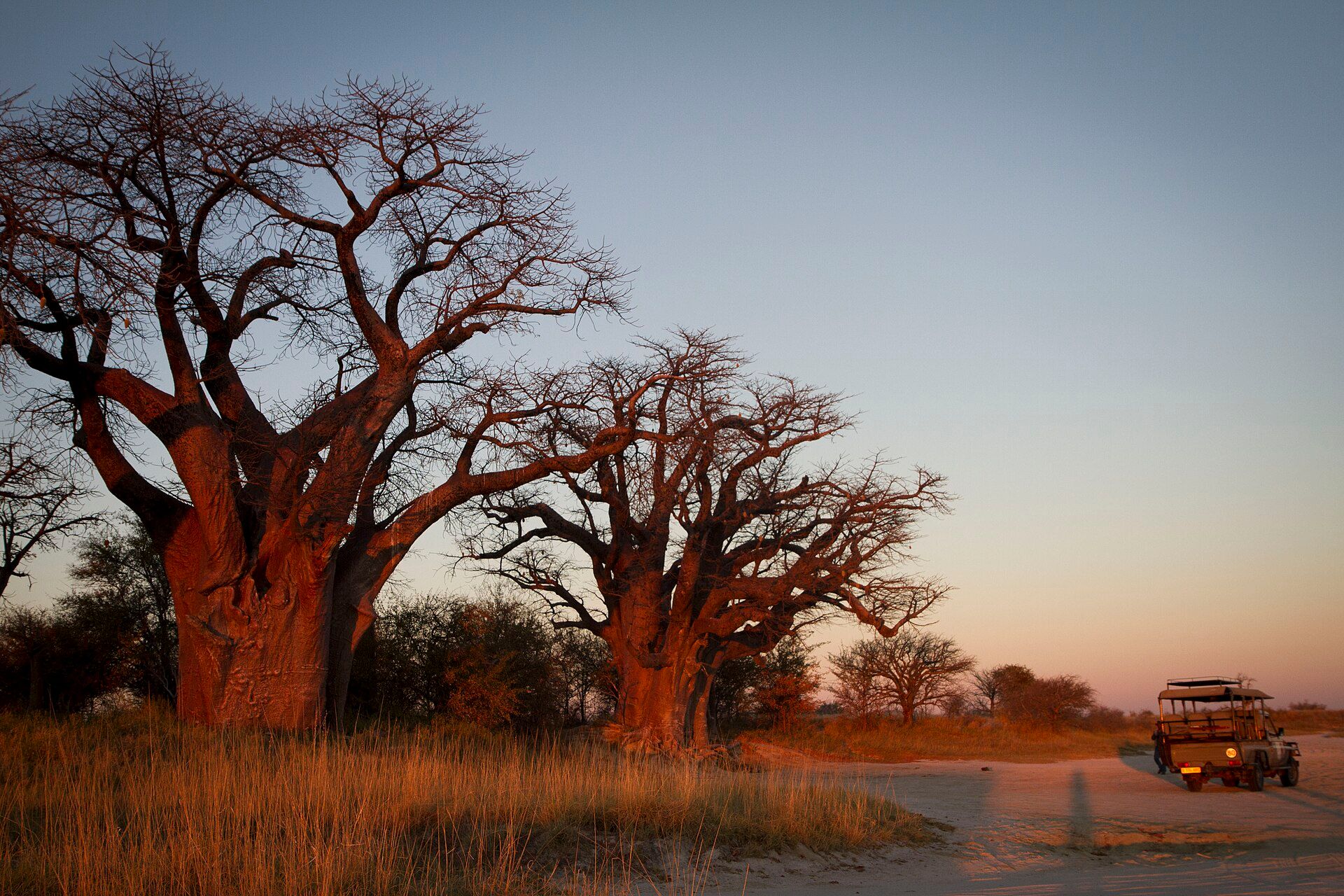
Nxai Pan National Park covers about 2,578 km² of northeastern Botswana and shares its southern edge with the Makgadikgadi Pans. At its heart lies Nxai Pan, a fossil lake bed of about 40 km² that is now grassland. Its best-known landmark is Baines' Baobabs, a group of huge, ancient baobab trees named after the explorer and artist Thomas Baines, who first described them for Western botany.
Why visit
In the rains the grasslands turn green and fill with zebra, wildebeest, springbok and giraffe, with lion, leopard and cheetah close behind. And Baines' Baobabs, glowing at sunset beside a white pan, are one of the most photographed scenes in Botswana.
What to know before you go
🗓️ Best time
The rainy season, November to April, when the park is at its best and wildlife is plentiful from December — though heavy rain can make roads difficult. The dry season, May to September, is easier to travel.
🧭 Getting there & access
The park lies just north of the main road between Maun and Nata. Tracks inside are sandy and a 4x4 is needed; many visitors come on a guided safari from Maun.
Good to know
- Time a visit to Baines' Baobabs for late afternoon light.
- In the rains, check road conditions before setting out.
- Combine it with the Makgadikgadi Pans just to the south.
Plan your visit
Moderate🧭 Getting there
From Maun (MUB), Botswana
- Fly to Maun
- Drive east on the Maun–Nata road to the park turn-off
- Continue on sandy 4x4 tracks into the park
- Total travel
- A few hours from Maun
- Time at site
- 1–2 nights
- Access
- Park entry fees apply and camping must be booked ahead. Tracks are sandy and can be very difficult after heavy rain; a 4x4 or guided safari is needed.
🎒 What to bring & consider
- A 4x4 or a booked safari
- Water, fuel and supplies — the park is remote
- Sun protection
- Binoculars
👁️ What to expect
- Crowds
- Quiet; numbers are small even in the green season.
- Conditions
- Hot days; very wet spells in the rains; cold nights in the dry season.
- Facilities
- Limited campsites and a small number of lodges.
- The view
- Baines' Baobabs lit red by the setting sun beside the pan.
Times and requirements are approximate and change with season, weather, and local rules — confirm permits, fares, and schedules with operators before you travel.
Natural riches of the area
- Nxai Pan, a fossil lake bed of about 40 km²
- Baines' Baobabs, a cluster of ancient trees
- Rainy-season grasslands with zebra, wildebeest and springbok
- Lion, leopard and cheetah
Local food
- Seswaa
- Slow-cooked, pounded beef — Botswana's national dish.
- Bogobe
- Sorghum porridge, a staple of Botswana's kitchens.
Nxai Pan is the green, wild sibling of the Makgadikgadi salt pans. Established as a national park in 1992 and covering about 2,578 km², it lies just north of the main road between Maun and Nata, sharing a border with the Makgadikgadi to the south. At its centre is Nxai Pan itself, a fossil lake bed of about 40 km² that has become open grassland.
That grass is the reason to come in the rains. From about December to April the park turns green and fills with zebra, wildebeest, springbok and giraffe, and the predators follow — lion, leopard and cheetah. In the dry season the landscape empties and turns gold, but it is easier to travel.
The park’s most famous sight is Baines’ Baobabs, a cluster of enormous, ancient baobabs standing on the edge of a white pan, named after the explorer and artist Thomas Baines. At sunset their bark glows red against a fading sky — a scene that sums up the Kalahari in a single frame.
Nxai Pan & Baines' Baobabs: common questions
How do you get to Nxai Pan & Baines' Baobabs?
From Maun (MUB), Botswana: Fly to Maun; Drive east on the Maun–Nata road to the park turn-off; Continue on sandy 4x4 tracks into the park. Total travel time: A few hours from Maun.
When is the best time to visit Nxai Pan & Baines' Baobabs?
The rainy season, November to April, when the park is at its best and wildlife is plentiful from December — though heavy rain can make roads difficult. The dry season, May to September, is easier to travel.
How long should you spend at Nxai Pan & Baines' Baobabs?
1–2 nights. Total travel time: A few hours from Maun.
What should you bring to Nxai Pan & Baines' Baobabs?
A 4x4 or a booked safari Water, fuel and supplies — the park is remote Sun protection Binoculars
Do you need a permit or guide for Nxai Pan & Baines' Baobabs?
Park entry fees apply and camping must be booked ahead. Tracks are sandy and can be very difficult after heavy rain; a 4x4 or guided safari is needed.
Is Nxai Pan & Baines' Baobabs crowded, and what are conditions like?
Quiet; numbers are small even in the green season. Hot days; very wet spells in the rains; cold nights in the dry season. Facilities: Limited campsites and a small number of lodges.
Added
More wonders to explore
Amboseli National Park
Kajiado County, southern Kenya, on the Tanzanian border
Queen Elizabeth National Park
Western Uganda, between Lake George and Lake Edward