Makgadikgadi Pans
📍 Northeastern Botswana, between Nata and Maun
Some of the largest salt pans on Earth — the dried floor of an ancient lake in the Kalahari, a blinding white plain that floods in the rains and draws zebra, wildebeest and flamingos.
What makes it marvelous
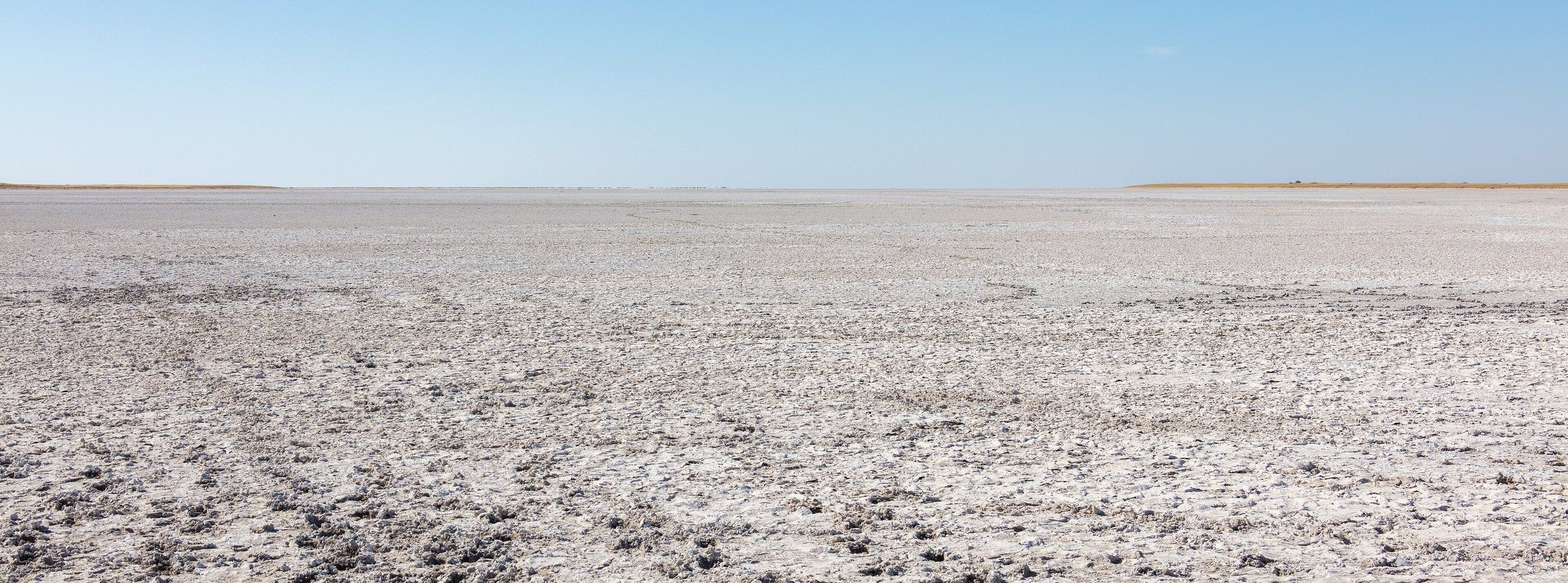
The Makgadikgadi salt pans cover about 16,000 km² of northeastern Botswana, the largest single pan alone about 4,900 km². They are what remains of Lake Makgadikgadi, a vast lake that dried up tens of thousands of years ago, leaving the main pans of Sua (Sowa) and Ntwetwe. In the dry season the surface is a flat, white crust stretching to the horizon; after the rains it fills with shallow water.
Why visit
It is one of the emptiest, most elemental landscapes in Africa — a place to stand on a salt plain with nothing in any direction. When the rains come, the pans transform: wildebeest and zebra arrive with their predators, and Sua Pan becomes one of only two breeding grounds for greater flamingos in southern Africa.
What to know before you go
🗓️ Best time
The wet season, roughly November to April, for wildlife and flamingos on flooded pans; the dry season, roughly May to October, for the classic white salt plain and easier driving.
🧭 Getting there & access
The pans lie between Nata and Maun in northeastern Botswana, with the village of Gweta a common base. Driving on the pans needs a 4x4, an experienced guide and great care: the crust can hide soft mud.
Good to know
- Never drive onto the pans without a guide or local knowledge — vehicles break through the crust.
- Come in the wet season for wildlife and flamingos, the dry season for the bare white plain.
- Carry more water and fuel than you think you need.
Plan your visit
Moderate🧭 Getting there
From Maun (MUB), Botswana
- Fly to Maun, or drive the main road from Nata
- Head to Gweta or a lodge on the edge of the pans
- Explore the pans only with a guide who knows the crust
- Total travel
- Several hours' drive from Maun
- Time at site
- 2–3 nights
- Access
- Much of the area is protected and fees apply in the national park. Pan driving is dangerous without local knowledge; many visitors go with a lodge or guided safari.
🎒 What to bring & consider
- A 4x4 and an experienced guide for the pans
- Extra water and fuel
- Sun protection — there is no shade on the salt
- Warm layers for cold desert nights in the dry season
👁️ What to expect
- Crowds
- Very few visitors; you may have the horizon to yourself.
- Conditions
- Searing sun and glare by day, cold nights in the dry season, flooding and mud in the wet season.
- Facilities
- Lodges and campsites around the edges; nothing on the pans themselves.
- The view
- The bare white crust running flat to the horizon under a deep blue sky.
Times and requirements are approximate and change with season, weather, and local rules — confirm permits, fares, and schedules with operators before you travel.
Natural riches of the area
- Salt pans covering about 16,000 km²
- The bed of ancient Lake Makgadikgadi
- One of two greater flamingo breeding sites in southern Africa
- Wet-season zebra and wildebeest with their predators
Local food
- Seswaa
- Slow-cooked, pounded beef — Botswana's national dish.
- Mopane worms
- Caterpillars of the emperor moth, dried and fried — a traditional protein across the region.
The Makgadikgadi Pans are the floor of a lake that is no longer there. Tens of thousands of years ago, Lake Makgadikgadi spread across this part of the Kalahari; as it dried, it left behind some of the largest salt pans on Earth, about 16,000 km² in all. The two great pans, Sua (Sowa) and Ntwetwe, are surrounded by grassland and scattered palms, and in the dry season their surface is a flat, white crust running to the horizon.
The rains change everything. When the pans flood, wildebeest and zebra move in with the predators that follow them, and migratory birds arrive — ducks, geese, pelicans and, on Sua Pan, greater flamingos at one of only two breeding sites in southern Africa. To the north, Nxai Pan National Park adjoins the area with its own fossil pan and the famous Baines’ Baobabs.
The pans are as dangerous as they are beautiful: the crust can hide deep mud, and vehicles that leave known tracks can break through. Explore them with a guide, come prepared for sun and cold, and expect to share the space with almost no one.
Makgadikgadi Pans: common questions
How do you get to Makgadikgadi Pans?
From Maun (MUB), Botswana: Fly to Maun, or drive the main road from Nata; Head to Gweta or a lodge on the edge of the pans; Explore the pans only with a guide who knows the crust. Total travel time: Several hours' drive from Maun.
When is the best time to visit Makgadikgadi Pans?
The wet season, roughly November to April, for wildlife and flamingos on flooded pans; the dry season, roughly May to October, for the classic white salt plain and easier driving.
How long should you spend at Makgadikgadi Pans?
2–3 nights. Total travel time: Several hours' drive from Maun.
What should you bring to Makgadikgadi Pans?
A 4x4 and an experienced guide for the pans Extra water and fuel Sun protection — there is no shade on the salt Warm layers for cold desert nights in the dry season
Do you need a permit or guide for Makgadikgadi Pans?
Much of the area is protected and fees apply in the national park. Pan driving is dangerous without local knowledge; many visitors go with a lodge or guided safari.
Is Makgadikgadi Pans crowded, and what are conditions like?
Very few visitors; you may have the horizon to yourself. Searing sun and glare by day, cold nights in the dry season, flooding and mud in the wet season. Facilities: Lodges and campsites around the edges; nothing on the pans themselves.
Added
More wonders to explore