Mount Bromo
📍 East Java, Indonesia
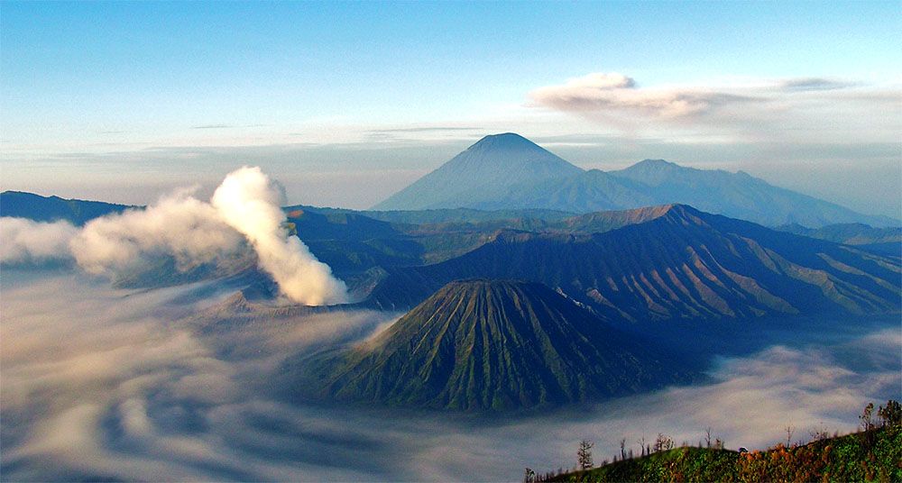
A smoking volcanic cone rising from a vast 'Sea of Sand' inside an ancient caldera — one of Earth's most dramatic sunrise views, ringed by the peaks of the Tengger massif in East Java.
What makes it marvelous
Bromo is an active volcano sitting within the enormous Tengger caldera, its crater constantly venting sulphurous steam. Around its base spreads the Sea of Sand — a flat plain of volcanic ash from ancient eruptions — from which Bromo and its neighbouring cones rise abruptly, with the perfect symmetrical cone of Semeru (Java's highest peak) smoking on the horizon. Indonesia sits on the Pacific Ring of Fire and has more active volcanoes than any country; Bromo is among its most iconic, and the Tengger people who farm the caldera floor around it gather at the crater rim for a large ceremony once a year.
Why visit
The classic experience is dawn: from a viewpoint on the caldera rim you watch the sun rise over a sea of cloud and ash with Bromo, its neighbours, and distant Semeru silhouetted and smoking — one of the most spectacular sunrises on the planet — before crossing the Sea of Sand to climb to Bromo's steaming crater rim.
Still deciding?
Mount Bromo comes up most often against these — each one weighs cost, effort, season and crowds side by side.
What to know before you go
🗓️ Best time
The dry season (roughly April–October) for clear sunrise views and passable tracks; the wet season brings cloud and mud. Check volcanic-activity status before visiting.
🧭 Getting there & access
From Malang or Probolinggo in East Java to villages like Cemoro Lawang on the caldera rim, then jeep and foot (or horseback) across the Sea of Sand to Bromo's crater; dawn viewpoints are nearby.
Good to know
- Go for sunrise from the caldera-rim viewpoints — it's the whole point.
- Dress warmly; the high caldera is cold before dawn despite the tropics.
- Check the volcano's alert status and heed any exclusion zone.
Plan your visit
Moderate🧭 Getting there
From Surabaya (SUB) or Malang, East Java
- Fly Jakarta → Surabaya — roughly 1h30
- Road Surabaya → Cemoro Lawang — about 3h30–4h30 depending on traffic
- Jeep to the sunrise viewpoint before dawn — 30–45 minutes
- Across the sand sea on foot or horseback, then around 250 steps to the crater rim
- Total travel
- Most of a day from Jakarta
- Time at site
- A night in Cemoro Lawang for the pre-dawn run; two if you want it unhurried
- Access
- Bromo Tengger Semeru National Park entry, priced differently on weekends and for foreign visitors. Access closes during heightened volcanic activity and around the Yadnya Kasada ceremony — check Indonesia's volcanology agency for the current alert status before you travel. Jeeps are effectively compulsory and arranged locally.
🎒 What to bring & consider
- A warm jacket, hat and gloves — at around 2,200m the pre-dawn cold genuinely shocks people who have come from the tropical lowlands
- A dust mask or buff; the sand sea is volcanic ash and the jeep convoy throws up a great deal of it
- A torch for the dark walk and the unlit steps
- Sturdy shoes for loose ash and worn stairs
- Cash for park fees, jeep hire and horses — none of it takes cards
👁️ What to expect
- Crowds
- The main Penanjakan sunrise viewpoint is genuinely packed, with jeeps queueing from the small hours. The alternative viewpoints and the crater rim itself are far quieter.
- Conditions
- A cold pre-dawn start, ash underfoot, and a steep stair climb to a rim with a sheer unfenced drop into the crater.
- Facilities
- Simple guesthouses and warungs in Cemoro Lawang. Nothing at all out on the sand sea.
- The view
- The caldera at sunrise with Semeru smoking behind is the classic. Cloud and haze fill the caldera often, and no amount of planning buys a clear morning.
Times and requirements are approximate and change with season, weather, and local rules — confirm permits, fares, and schedules with operators before you travel.
Natural riches of the area
- An active volcano within a giant caldera (the Tengger massif)
- The ash plain 'Sea of Sand' and surrounding peaks
- Fertile volcanic soils supporting highland farming
- Geothermal energy and living volcanic geology
Local food
- Nasi goreng
- Indonesia's beloved fried rice, often topped with a fried egg.
- Bakso
- Hot meatball soup, a warming highland favourite.
- Tengger highland produce
- Potatoes, cabbage, and hardy crops grown on the volcanic slopes.
Mount Bromo delivers one of the great sunrises on Earth. From a viewpoint on the rim of the vast Tengger caldera in East Java, you look out before dawn over a flat ‘Sea of Sand’ — a plain of ancient volcanic ash — from which Bromo and its neighbouring cones rise abruptly, steam curling from Bromo’s crater and the perfect pyramid of distant Semeru smoking on the horizon. As the sun comes up over the sea of cloud and ash, the whole scene ignites.
Indonesia rides the Pacific Ring of Fire and has more active volcanoes than any nation on Earth, and Bromo is among its most beloved. The Tengger people farm the caldera floor around it and gather at the crater rim for a large ceremony once a year. After sunrise you can cross the ash plain and climb to the steaming crater rim itself. Just check the volcano’s alert status first: this is a living mountain, still very much awake.
Mount Bromo: common questions
How do you get to Mount Bromo?
From Surabaya (SUB) or Malang, East Java: Fly Jakarta → Surabaya — roughly 1h30; Road Surabaya → Cemoro Lawang — about 3h30–4h30 depending on traffic; Jeep to the sunrise viewpoint before dawn — 30–45 minutes; Across the sand sea on foot or horseback, then around 250 steps to the crater rim. Total travel time: Most of a day from Jakarta.
When is the best time to visit Mount Bromo?
The dry season (roughly April–October) for clear sunrise views and passable tracks; the wet season brings cloud and mud. Check volcanic-activity status before visiting.
How long should you spend at Mount Bromo?
A night in Cemoro Lawang for the pre-dawn run; two if you want it unhurried. Total travel time: Most of a day from Jakarta.
What should you bring to Mount Bromo?
A warm jacket, hat and gloves — at around 2,200m the pre-dawn cold genuinely shocks people who have come from the tropical lowlands A dust mask or buff; the sand sea is volcanic ash and the jeep convoy throws up a great deal of it A torch for the dark walk and the unlit steps Sturdy shoes for loose ash and worn stairs Cash for park fees, jeep hire and horses — none of it takes cards
Do you need a permit or guide for Mount Bromo?
Bromo Tengger Semeru National Park entry, priced differently on weekends and for foreign visitors. Access closes during heightened volcanic activity and around the Yadnya Kasada ceremony — check Indonesia's volcanology agency for the current alert status before you travel. Jeeps are effectively compulsory and arranged locally.
Is Mount Bromo crowded, and what are conditions like?
The main Penanjakan sunrise viewpoint is genuinely packed, with jeeps queueing from the small hours. The alternative viewpoints and the crater rim itself are far quieter. A cold pre-dawn start, ash underfoot, and a steep stair climb to a rim with a sheer unfenced drop into the crater. Facilities: Simple guesthouses and warungs in Cemoro Lawang. Nothing at all out on the sand sea.
Added Updated
More wonders to explore