The Curonian Spit
📍 Klaipėda County, western Lithuania, extending into Kaliningrad Oblast
A 98-kilometre ribbon of sand dune separating a lagoon from the Baltic — never more than a few kilometres wide, and standing only because two centuries of deliberate replanting stopped it burying itself.
What makes it marvelous
The spit is a sand bar 98 kilometres long and, at its narrowest, 400 metres wide, curving north from the Sambia Peninsula to a strait opposite Klaipėda and separating the Curonian Lagoon from the open Baltic. It formed around five thousand years ago on a glacial moraine foundation, with wind and currents piling enough sand on top to lift it above sea level and keep it there. Geologically it is a temporary object: it exists only while sand supply and removal stay in balance, and the likeliest long-term outcome is that the lagoon behind it silts up into new land. Its recent history is a case study in how quickly a landform like this can be destabilised. Grazing, timber felling and shipbuilding stripped the spit's forest from the sixteenth century onward, and by the eighteenth the freed dunes were on the move and burying whole villages. Replanting and stabilisation work began in 1825 and has continued ever since — which is why the spit is a UNESCO World Heritage Site listed for the interaction of people and landscape rather than for wilderness.
Why visit
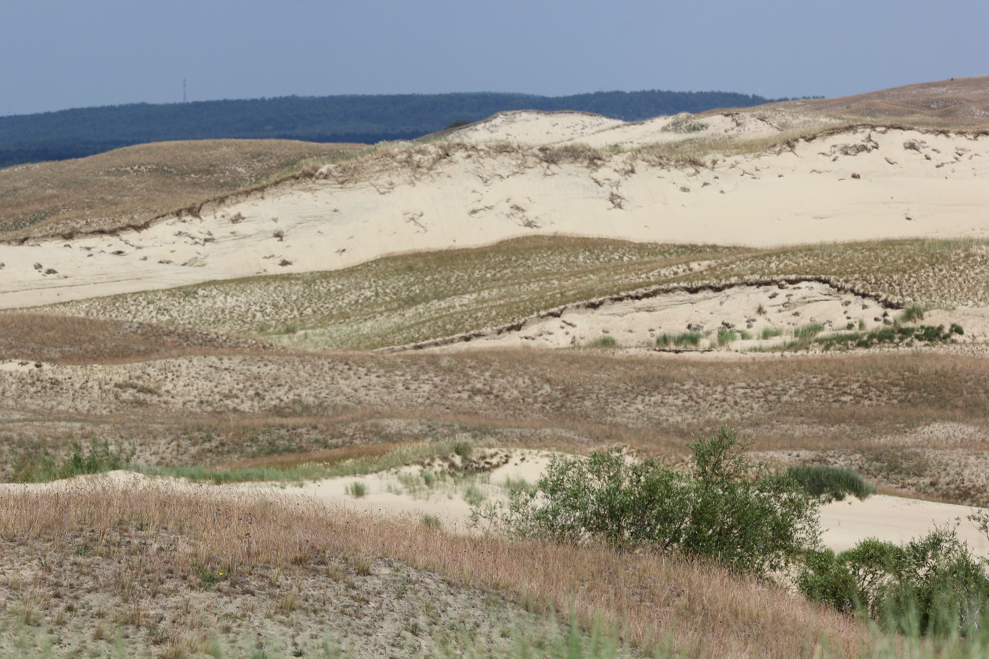
The Grey Dunes near Nida are the most striking part: a wide expanse of sand ridges held together by marram, with the lagoon on one side and the Baltic on the other, both visible from the top. It is flat, easy and quiet, and the whole spit can be cycled end to end on a made path through pine forest.
What to know before you go
🗓️ Best time
May to September is the season, with June to August warmest and busiest. Late spring and early autumn give the best light on the dunes and far fewer people. Winter is bleak, windy and largely shut, though the forest walking stays open.
🧭 Getting there & access
From Klaipėda, a short ferry crosses to Smiltynė at the northern tip; the road then runs the length of the Lithuanian section through Juodkrantė to Nida, about 50 km. Vehicles pay an environmental fee to enter. A cycle path runs the whole way. The southern half of the spit is in Russian territory and the border crossing is not a routine tourist route.
Good to know
- Cycle rather than drive — the path runs the full length and the spit is flat.
- Stay on the boardwalks on the Grey Dunes; the marram holding them together is the only thing stopping them moving.
- Nida is the best base for the dunes; Juodkrantė is quieter.
- The Baltic side is open surf and the lagoon side is calm — check which beach you actually want.
Plan your visit
Easy🧭 Getting there
From Klaipėda, Lithuania
- Travel to Klaipėda by road, rail or ferry
- Take the short ferry across to Smiltynė
- Drive or cycle south through Juodkrantė to Nida
- Walk the Parnidis dune and the Grey Dunes from there
- Total travel
- Under an hour from Klaipėda to Nida
- Time at site
- 2–3 days
- Access
- An environmental fee is charged for vehicles entering the national park, paid at the ferry or the barrier. The dunes have marked paths and boardwalks and walking off them is prohibited — the stabilisation is fragile and actively maintained. The Russian half of the spit is a separate country with its own entry requirements.
🎒 What to bring & consider
- A bicycle, hired in Klaipėda or Nida, which is the best way to cover it
- Wind protection; the Baltic side is exposed in any season
- Sun protection on the open dunes, where there is no shade at all
- Insect repellent for the forest in midsummer
- Accommodation booked ahead for July and August
👁️ What to expect
- Crowds
- Busy in Nida in July and August. The forest sections and the northern end stay quiet.
- Conditions
- Flat, sandy and windy. Easy walking and cycling throughout.
- Facilities
- Full services in Nida, Juodkrantė and Smiltynė — accommodation, food, bike hire, visitor centres.
- The view
- The Grey Dunes from the boardwalk in low evening light, with the ridges running away and both the lagoon and the Baltic in frame.
Times and requirements are approximate and change with season, weather, and local rules — confirm permits, fares, and schedules with operators before you travel.
Natural riches of the area
- A 98 km sand spit, 400 m to 3,800 m wide, on a glacial moraine base
- The Grey Dunes near Nida, among the largest drifting dune fields in Europe
- The Curonian Lagoon, separated from the Baltic by the spit itself
- Planted pine forest covering most of the spit, the result of two centuries of stabilisation
- A major migratory bird flyway along the Baltic coast
Local food
- Smoked fish
- Bream, eel and perch from the lagoon, smoked in the villages and sold at the roadside.
- Cepelinai
- Potato dumplings stuffed with meat, the Lithuanian national dish.
- Šaltibarščiai
- Cold beetroot soup with kefir, bright pink and eaten all summer.
- Rye bread
- Dark, dense and sour — the staple, and taken seriously.
The Curonian Spit is 98 kilometres of sand and, in places, 400 metres wide. It curves up the eastern Baltic from the Sambia Peninsula to a narrow strait opposite Klaipėda, and it separates a large shallow lagoon from the open sea. It formed around five thousand years ago: a glacial moraine gave it a foundation, and wind and currents piled enough sand on top to raise it clear of the water and hold it there.
That balance is the whole story. A spit exists only while sand arriving and sand leaving stay roughly equal, which makes it a genuinely temporary landform — the likeliest long-term future here is that the lagoon behind silts up and becomes land. On a shorter timescale, people nearly ended it much sooner. From the sixteenth century the spit’s forest was grazed, felled for timber and cut for shipbuilding, and by the eighteenth century the dunes had been released. They moved, and they buried villages.
The response, beginning in 1825, was replanting on an enormous scale, and it has never stopped. Most of the spit today is planted pine, and the open dunes that remain are held in place by marram grass that is actively maintained. That is why UNESCO listed the spit in 2000 as a cultural landscape rather than a natural one: what you are looking at is a natural landform that only still exists because two centuries of people kept putting it back.
For a visitor it is one of the easiest great landscapes in Europe to spend time in. It is flat, a cycle path runs its full Lithuanian length, and from the top of the Grey Dunes near Nida you can see the lagoon on one side and the Baltic on the other at the same time. Stay on the boardwalks; the grass under them is doing the work.
The Curonian Spit: common questions
How do you get to The Curonian Spit?
From Klaipėda, Lithuania: Travel to Klaipėda by road, rail or ferry; Take the short ferry across to Smiltynė; Drive or cycle south through Juodkrantė to Nida; Walk the Parnidis dune and the Grey Dunes from there. Total travel time: Under an hour from Klaipėda to Nida.
When is the best time to visit The Curonian Spit?
May to September is the season, with June to August warmest and busiest. Late spring and early autumn give the best light on the dunes and far fewer people. Winter is bleak, windy and largely shut, though the forest walking stays open.
How long should you spend at The Curonian Spit?
2–3 days. Total travel time: Under an hour from Klaipėda to Nida.
What should you bring to The Curonian Spit?
A bicycle, hired in Klaipėda or Nida, which is the best way to cover it Wind protection; the Baltic side is exposed in any season Sun protection on the open dunes, where there is no shade at all Insect repellent for the forest in midsummer Accommodation booked ahead for July and August
Do you need a permit or guide for The Curonian Spit?
An environmental fee is charged for vehicles entering the national park, paid at the ferry or the barrier. The dunes have marked paths and boardwalks and walking off them is prohibited — the stabilisation is fragile and actively maintained. The Russian half of the spit is a separate country with its own entry requirements.
Is The Curonian Spit crowded, and what are conditions like?
Busy in Nida in July and August. The forest sections and the northern end stay quiet. Flat, sandy and windy. Easy walking and cycling throughout. Facilities: Full services in Nida, Juodkrantė and Smiltynė — accommodation, food, bike hire, visitor centres.
Added
More wonders to explore