Acadia National Park
📍 Mount Desert Island, the Schoodic Peninsula and Isle au Haut on the coast of Maine, USA, beside Bar Harbor
Granite mountains rising straight from the Gulf of Maine: nearly 50,000 acres of glacier-scoured summits, cobble beaches and spruce-fringed headlands, topped by 1,530-ft Cadillac Mountain, the highest point on the US eastern seaboard.
What makes it marvelous
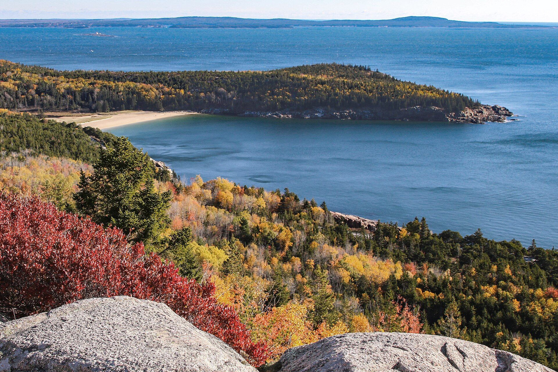
Acadia protects the highest rocky headlands along the Atlantic coast of the United States — nearly 50,000 acres across Mount Desert Island, the Schoodic Peninsula and Isle au Haut. The bedrock of Mount Desert Island is granite about 420 million years old. During the last glaciation, which peaked about 18,000 years ago, ice sheets ground over the island, rounding its summits and cutting broad U-shaped valleys between them; as the ice melted it left boulders scattered across the bare granite. The highest summit, Cadillac Mountain, reaches 1,530 ft (466 m), the highest point on the eastern seaboard of the US, and from 7 October to 6 March it is the first place in the country to see the sunrise. Along the shore, Sand Beach is made mostly of fragments of shells and other marine life, while the coves open to the full force of the waves hold only pebbles, cobbles and boulders.
Why visit
Watch the sunrise from the bare granite of Cadillac Mountain, walk or cycle the 45 miles of car-free carriage roads past ponds and forest, and follow the Park Loop Road along a coast of granite cliffs and pounding surf.
What to know before you go
🗓️ Best time
Summer and early autumn. Summer days range from about 45 to 90 °F (7–32 °C), with ocean water only 50–60 °F (10–16 °C) and fast changes from sun to cold rain. Autumn colour generally peaks in mid-October. The Park Loop Road is open from 15 April to 1 December; in winter, most park roads are closed and the high peaks are much colder than Bar Harbor.
🧭 Getting there & access
Most visitors base themselves in Bar Harbor on Mount Desert Island; the Hulls Cove Visitor Center is at 25 Visitor Center Road, Bar Harbor. The 27-mile Park Loop Road links Sand Beach, Thunder Hole, Jordan Pond and the Cadillac Summit Road, and the fare-free Island Explorer bus runs around the island to reduce congestion. The Schoodic Peninsula is on the mainland across Frenchman Bay, and Isle au Haut is reached only by passenger ferry.
Good to know
- A park entrance pass is required year-round; to drive the Cadillac Summit Road you also need a separate vehicle reservation, sold only on Recreation.gov (required 20 May to 25 October in 2026).
- Ride the fare-free Island Explorer bus instead of hunting for parking at Sand Beach, Jordan Pond and other busy stops.
- There is no backcountry camping or overnight parking in the park — book a campground online in advance.
- Pets are welcome on a leash no longer than 6 ft (2 m) at all times.
Plan your visit
Easy🧭 Getting there
From Bar Harbor, Maine, on Mount Desert Island; the nearest airports are Hancock County–Bar Harbor (BHB) and Bangor (BGR)
- Fly into Bangor or Bar Harbor, or drive up the Maine coast
- Cross onto Mount Desert Island and stop at the Hulls Cove Visitor Center
- Follow the 27-mile Park Loop Road past Sand Beach, Thunder Hole and Jordan Pond, or ride the Island Explorer bus
- Take the Cadillac Summit Road (vehicle reservation needed in season) for sunrise or sunset
- Total travel
- Base in Bar Harbor, beside the Hulls Cove Visitor Center
- Time at site
- Two days for the Park Loop Road, Cadillac and the carriage roads; add a day for the quieter Schoodic Peninsula or the ferry to Isle au Haut
- Access
- A park entrance pass is required year-round — confirm current fees with the National Park Service (nps.gov/acad). Driving the Cadillac Summit Road also needs a separate timed vehicle reservation from Recreation.gov in season (20 May to 25 October in 2026); part of the reservations go on sale 90 days ahead and the rest two days ahead. The Park Loop Road is open 15 April to 1 December. No backcountry camping or overnight parking.
🎒 What to bring & consider
- Your entrance pass and, in season, a Cadillac Summit Road reservation
- Warm layers and a rain shell, even in summer — weather turns quickly and the summits are colder than town
- A headlamp and warm jacket for sunrise on Cadillac
- Good shoes for granite ledges and rocky trails
👁️ What to expect
- Crowds
- About 4 million visits a year, making it one of the ten most visited US national parks; the east side of Mount Desert Island is busiest, and Schoodic sees far fewer people.
- Conditions
- Paved loop road and short shoreline walks, gravel carriage roads, and steep granite trails on the mountains.
- Facilities
- Visitor center at Hulls Cove, campgrounds bookable online, the Jordan Pond House restaurant in season, and full services in Bar Harbor.
- The view
- First light on the granite of Cadillac Mountain with the Porcupine Islands scattered across Frenchman Bay below.
Times and requirements are approximate and change with season, weather, and local rules — confirm permits, fares, and schedules with operators before you travel.
Natural riches of the area
- Cadillac Mountain, 1,530 ft (466 m), the highest point on the US eastern seaboard
- About 420-million-year-old granite shaped by Ice Age glaciers
- Sand Beach, built mostly from shell fragments, and cobble beaches on the open coast
- Jordan Pond and the glacier-cut valleys between the island's summits
- 158 miles of hiking trails and 45 miles of historic carriage roads
Local food
- Maine lobster
- Steamed lobster dinners and lobster rolls from the harbour towns of Mount Desert Island.
- Wild blueberries
- Maine's small lowbush blueberries, baked into pies and muffins across Downeast Maine in late summer.
Acadia National Park guards the highest rocky headlands on the Atlantic coast of the United States. It covers nearly 50,000 acres of Maine, most of it on Mount Desert Island beside Bar Harbor, with more on the mainland Schoodic Peninsula and on remote Isle au Haut. It began in 1916 as Sieur de Monts National Monument, about 5,000 acres of donated land. Congress made it Lafayette National Park in 1919 and renamed it Acadia in 1929.
The island is built of granite about 420 million years old. During the last ice age, which peaked about 18,000 years ago, glaciers rode over it, rounding the summits, carving broad U-shaped valleys between them and dropping boulders on the bare rock as they melted. The highest summit, Cadillac Mountain, reaches 1,530 feet, the highest point on the eastern seaboard of the US. From 7 October to 6 March it is the first place in the country to catch the sunrise. Down at the shore, Sand Beach is made mostly of crushed shells. Coves that face the open ocean keep only cobbles and boulders, because the waves carry anything smaller away.
About 4 million visits a year make Acadia one of the ten most visited US national parks. Most people follow the 27-mile Park Loop Road or walk and cycle the 45 miles of car-free carriage roads. Come between June and October, ride the free Island Explorer bus, and book a vehicle reservation if you want to drive up Cadillac.
Acadia National Park: common questions
How do you get to Acadia National Park?
From Bar Harbor, Maine, on Mount Desert Island; the nearest airports are Hancock County–Bar Harbor (BHB) and Bangor (BGR): Fly into Bangor or Bar Harbor, or drive up the Maine coast; Cross onto Mount Desert Island and stop at the Hulls Cove Visitor Center; Follow the 27-mile Park Loop Road past Sand Beach, Thunder Hole and Jordan Pond, or ride the Island Explorer bus; Take the Cadillac Summit Road (vehicle reservation needed in season) for sunrise or sunset. Total travel time: Base in Bar Harbor, beside the Hulls Cove Visitor Center.
When is the best time to visit Acadia National Park?
Summer and early autumn. Summer days range from about 45 to 90 °F (7–32 °C), with ocean water only 50–60 °F (10–16 °C) and fast changes from sun to cold rain. Autumn colour generally peaks in mid-October. The Park Loop Road is open from 15 April to 1 December; in winter, most park roads are closed and the high peaks are much colder than Bar Harbor.
How long should you spend at Acadia National Park?
Two days for the Park Loop Road, Cadillac and the carriage roads; add a day for the quieter Schoodic Peninsula or the ferry to Isle au Haut. Total travel time: Base in Bar Harbor, beside the Hulls Cove Visitor Center.
What should you bring to Acadia National Park?
Your entrance pass and, in season, a Cadillac Summit Road reservation Warm layers and a rain shell, even in summer — weather turns quickly and the summits are colder than town A headlamp and warm jacket for sunrise on Cadillac Good shoes for granite ledges and rocky trails
Do you need a permit or guide for Acadia National Park?
A park entrance pass is required year-round — confirm current fees with the National Park Service (nps.gov/acad). Driving the Cadillac Summit Road also needs a separate timed vehicle reservation from Recreation.gov in season (20 May to 25 October in 2026); part of the reservations go on sale 90 days ahead and the rest two days ahead. The Park Loop Road is open 15 April to 1 December. No backcountry camping or overnight parking.
Is Acadia National Park crowded, and what are conditions like?
About 4 million visits a year, making it one of the ten most visited US national parks; the east side of Mount Desert Island is busiest, and Schoodic sees far fewer people. Paved loop road and short shoreline walks, gravel carriage roads, and steep granite trails on the mountains. Facilities: Visitor center at Hulls Cove, campgrounds bookable online, the Jordan Pond House restaurant in season, and full services in Bar Harbor.
Added