Jasmund Chalk Cliffs
📍 Jasmund National Park, Rügen, Mecklenburg-Vorpommern, Germany
Germany's largest chalk cliffs, dropping white into the Baltic on the island of Rügen — topped by the last great beech forest on this coast, and eroding fast enough that the shoreline is measurably different within a lifetime.
What makes it marvelous
The chalk is compressed plankton. It formed on the floor of a warm Cretaceous sea from the microscopic calcite plates of coccolithophores, settling for millions of years, and was later shoved into folds and pushed up by advancing ice-age glaciers — which is why the beds inside the cliffs are contorted rather than flat. The highest point, the Königsstuhl, stands 118 metres above the Baltic. What makes the site more than a viewpoint is what grows on top: roughly 2,100 hectares of beech forest, the largest continuous stand on the Baltic coast, inscribed by UNESCO in 2011 as part of the transnational primeval beech forest listing. Chalk is soft and porous, so the cliffs retreat continuously — rain seeps in, frost prises blocks free, and sections collapse onto the shore, which is why the coastline here is genuinely different from one decade to the next.
Why visit
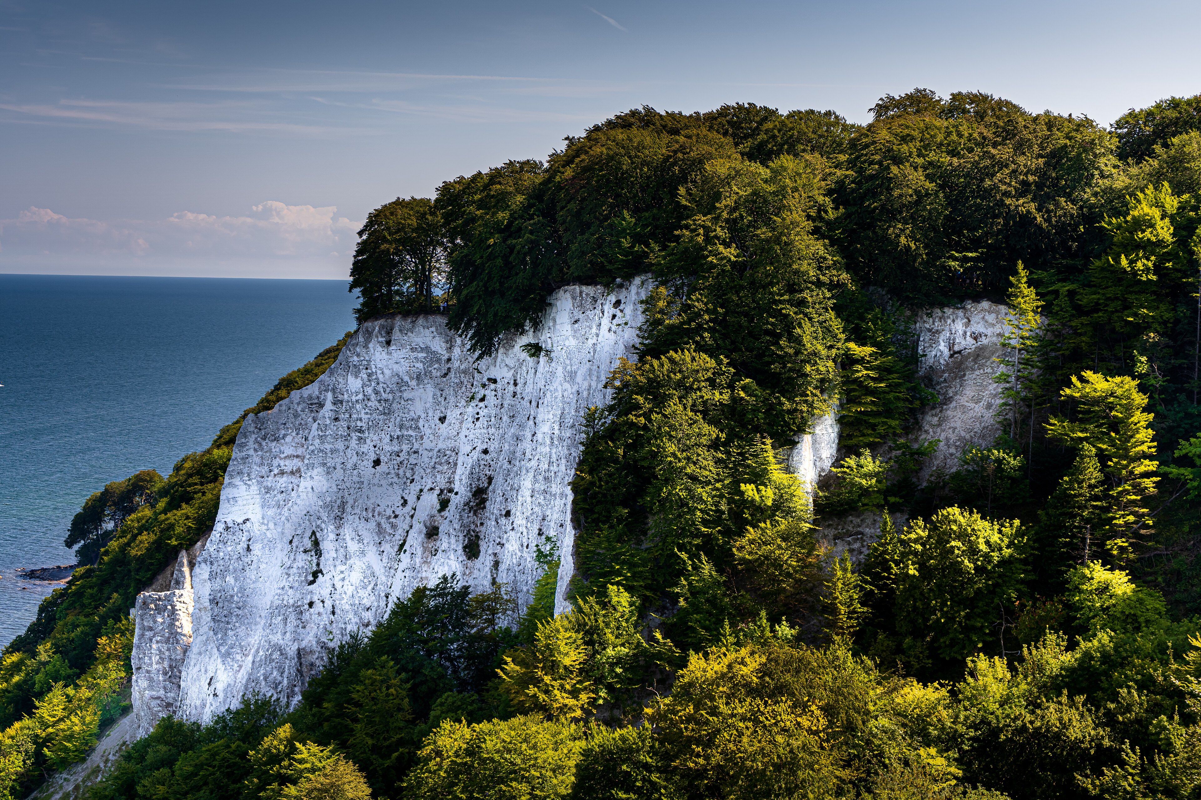
The contrast is the thing: dark green beech canopy running right to the lip of a brilliant white cliff, above a cold blue-grey sea. A cliff-top path runs the length of it with viewpoints down onto the collapses, and the shingle beach below lets you walk at the foot of the chalk and find fossils weathering out of it.
What to know before you go
🗓️ Best time
May to September for warm weather and long daylight, with the beech canopy at its densest in early summer. Autumn brings colour and far fewer people. Winter is bleak and often beautiful, but the cliff-top paths get slippery and sections close after collapses.
🧭 Getting there & access
Rügen is connected to the mainland by bridge and served by rail to Sassnitz, roughly 4 hours from Berlin. The national park centre at Königsstuhl is the main access point and is ticketed; the surrounding cliff-top and forest trails are free. A shuttle bus runs from Sassnitz in season.
Good to know
- Walk the cliff-top path from Sassnitz rather than only visiting the ticketed viewing platform.
- Do not stand at the very edge or directly beneath the cliff — collapses here are frequent and unannounced.
- The beach below is reached by a small number of stairways; check where they are before setting off.
- Come out of season if you can; the Königsstuhl platform is genuinely crowded in July and August.
Plan your visit
Easy🧭 Getting there
From Berlin or Hamburg, then Rügen
- Travel to Rügen by rail or road across the Rügen bridge
- Continue to Sassnitz, roughly 4 hours from Berlin
- Reach the Königsstuhl centre by shuttle bus, bike or on foot
- Walk the cliff-top path north or south along the coast
- Total travel
- Around half a day from Berlin
- Time at site
- A full day; two if you want the forest as well as the cliffs
- Access
- The Königsstuhl national park centre and its viewing platform are ticketed and busy. The surrounding cliff-top and forest trails are free and open. Sections of path close without notice after cliff collapses — obey the closures rather than routing around them.
🎒 What to bring & consider
- Proper shoes; the cliff-top path is root-crossed and slippery after rain
- Wind and rain protection for an exposed Baltic coast in any season
- Respect for the edge and the base — the chalk fails suddenly and without warning
- Cash or card for the centre ticket and the shuttle
- Binoculars for seabirds along the cliff faces
👁️ What to expect
- Crowds
- The Königsstuhl platform is heavily visited in summer. Walk twenty minutes along the coast path and the numbers drop sharply.
- Conditions
- Cool, breezy and often damp. Gentle forest walking on top; steep stairways down to the shingle.
- Facilities
- Full visitor centre with cafe and toilets at Königsstuhl; services in Sassnitz. Nothing on the beach.
- The view
- The white cliff face with beech canopy above it and the Baltic behind, in low afternoon light from one of the coast-path viewpoints.
Times and requirements are approximate and change with season, weather, and local rules — confirm permits, fares, and schedules with operators before you travel.
Natural riches of the area
- Germany's largest chalk cliffs, rising to 118 m at the Königsstuhl
- Roughly 2,100 ha of beech forest, the largest continuous stand on the Baltic coast
- Cretaceous chalk built from the calcite plates of marine plankton
- Glacially folded and thrust chalk beds, visible in the cliff faces
- Fossils weathering out of the chalk onto the shingle beach below
Local food
- Räucherfisch
- Smoked Baltic fish, sold from harbour smokehouses along the Rügen coast.
- Sanddorn
- Sea buckthorn, grown along this coast and made into juice and preserves.
- Rügener Badejunge
- A soft island cheese from Rügen's own dairy tradition.
- Fischbrötchen
- The North German fish roll — pickled or fried fish in a bread bun.
The chalk at Jasmund is compressed plankton. It accumulated on the floor of a warm Cretaceous sea from the calcite plates of coccolithophores — organisms too small to see — settling for millions of years until the deposit was hundreds of metres thick. Ice-age glaciers then shoved into it, folding and thrusting the beds, which is why the layering inside these cliffs is buckled rather than flat. The highest point, the Königsstuhl, stands 118 metres above the Baltic, and they are the largest chalk cliffs in Germany.
What lifts the site above a viewpoint is the forest on top. Roughly 2,100 hectares of beech run right to the cliff edge — the largest continuous beech stand on the Baltic coast — and UNESCO inscribed it in 2011 as part of the transnational primeval beech forest listing. The two halves are worth seeing together: dark canopy, brilliant white rock, cold grey-blue sea.
It is also visibly temporary. Chalk is soft and porous; water gets in, frost levers blocks loose, and slabs of cliff drop onto the beach on a regular basis. Paths close after collapses and the coastline is measurably different across a single lifetime. Standing at the edge, or directly under it, is the one thing not to do here.
Jasmund Chalk Cliffs: common questions
How do you get to Jasmund Chalk Cliffs?
From Berlin or Hamburg, then Rügen: Travel to Rügen by rail or road across the Rügen bridge; Continue to Sassnitz, roughly 4 hours from Berlin; Reach the Königsstuhl centre by shuttle bus, bike or on foot; Walk the cliff-top path north or south along the coast. Total travel time: Around half a day from Berlin.
When is the best time to visit Jasmund Chalk Cliffs?
May to September for warm weather and long daylight, with the beech canopy at its densest in early summer. Autumn brings colour and far fewer people. Winter is bleak and often beautiful, but the cliff-top paths get slippery and sections close after collapses.
How long should you spend at Jasmund Chalk Cliffs?
A full day; two if you want the forest as well as the cliffs. Total travel time: Around half a day from Berlin.
What should you bring to Jasmund Chalk Cliffs?
Proper shoes; the cliff-top path is root-crossed and slippery after rain Wind and rain protection for an exposed Baltic coast in any season Respect for the edge and the base — the chalk fails suddenly and without warning Cash or card for the centre ticket and the shuttle Binoculars for seabirds along the cliff faces
Do you need a permit or guide for Jasmund Chalk Cliffs?
The Königsstuhl national park centre and its viewing platform are ticketed and busy. The surrounding cliff-top and forest trails are free and open. Sections of path close without notice after cliff collapses — obey the closures rather than routing around them.
Is Jasmund Chalk Cliffs crowded, and what are conditions like?
The Königsstuhl platform is heavily visited in summer. Walk twenty minutes along the coast path and the numbers drop sharply. Cool, breezy and often damp. Gentle forest walking on top; steep stairways down to the shingle. Facilities: Full visitor centre with cafe and toilets at Königsstuhl; services in Sassnitz. Nothing on the beach.
Added