Wadden Sea
📍 Netherlands, Germany & Denmark
The largest unbroken system of intertidal sand and mud flats on Earth — a vast tidal wilderness that feeds 10 to 12 million migratory birds a year.
What makes it marvelous
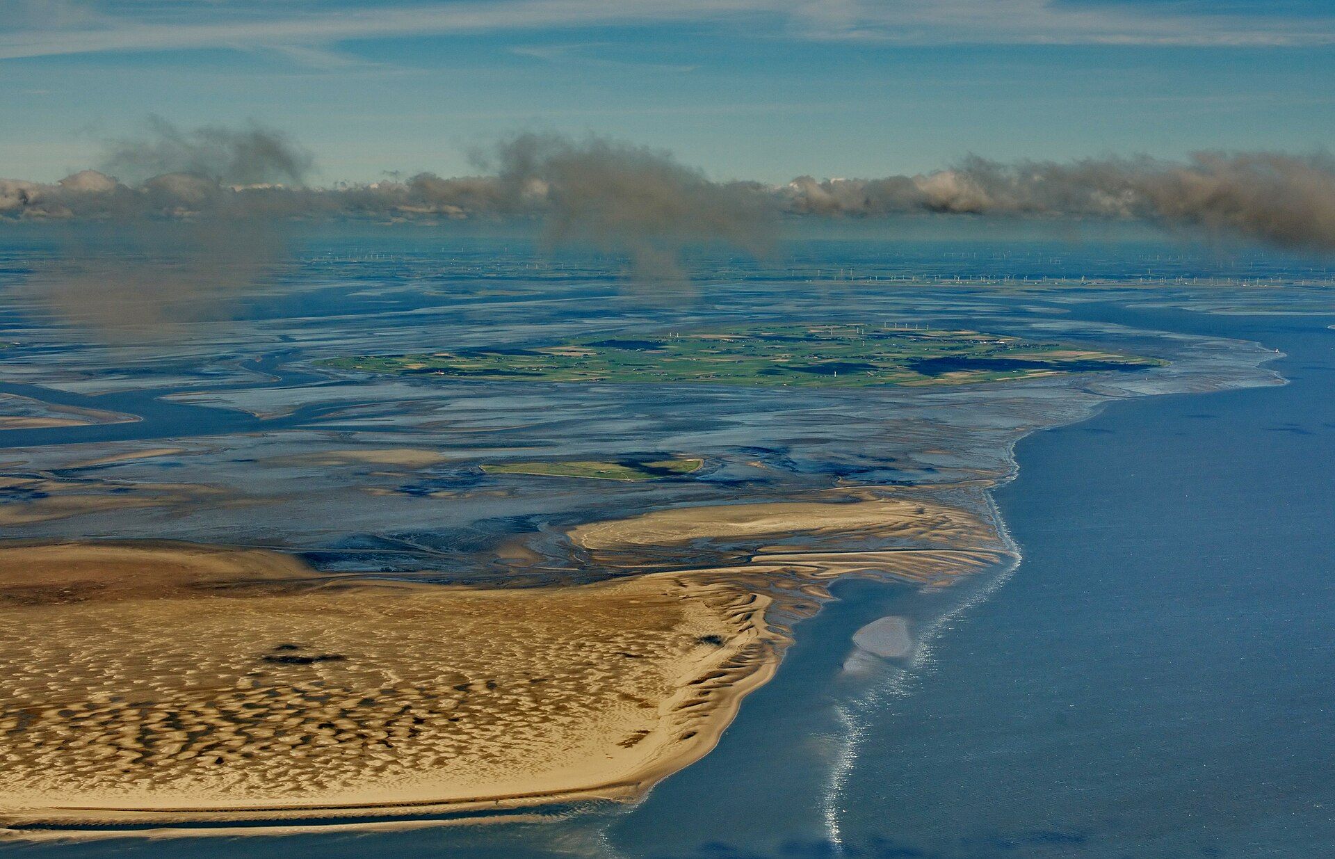
Stretching some 500 kilometres along the North Sea coast from the Netherlands through Germany to Denmark, the Wadden Sea is the largest unbroken system of intertidal sand and mud flats in the world. Twice a day the tide withdraws to expose an immense plain of glistening mud, then floods back over it — a rhythm that makes the flats extraordinarily productive, packed with worms, molluscs, and crustaceans. That abundance underpins one of the great migrations on Earth: between 10 and 12 million birds pass through each year, refuelling here on their journeys between the Arctic and Africa, and for many species the Wadden is an irreplaceable link in the chain. Seals haul out on the sandbanks, and the shifting barrier islands and channels are constantly remade by tide and storm. It is a UNESCO World Heritage Site.
Why visit
Walking out across the seabed at low tide on a guided mudflat hike — with millions of birds wheeling overhead in migration season and seals on the sandbanks — is a genuinely unusual and quietly extraordinary experience.
What to know before you go
🗓️ Best time
Spring and autumn (roughly April–May and August–October) for peak bird migration; summer is best for mudflat walking and mild weather.
🧭 Getting there & access
Along the coasts of the Netherlands, Germany, and Denmark, reached from mainland towns or the barrier islands (Texel, Sylt, Fanø and others); guided wadlopen mudflat walks depart at low tide.
Good to know
- Only cross the flats with a licensed guide — the returning tide is dangerous.
- Time a visit to spring or autumn migration for the biggest bird numbers.
- Bring binoculars; much of the spectacle is at a distance across the flats.
Plan your visit
Moderate🧭 Getting there
From Leeuwarden or Holwerd, Friesland, Netherlands
- Drive or train to the Frisian coast — Holwerd for Ameland, Lauwersoog for Schiermonnikoog
- Join a licensed mudflat-walking (wadlopen) group, or take the ferry to a Wadden island
- Walk the flats with the guide on the falling tide — timed precisely to the water
- Total travel
- A few hours from the Randstad to the coast
- Time at site
- A half-day mudflat walk, or days out on the islands
- Access
- The single most important fact about the Wadden Sea is the tide: the flats you walk on are under the sea twice a day, the channels fill fast, and fog rolls in — so mudflat walking (wadlopen) is done only with a licensed guide who reads the tide tables and the crossings, never alone. This is not caution, it is how people avoid drowning here. Guided walks are booked ahead through the wadlopen organisations. The islands themselves — Ameland, Schiermonnikoog, Terschelling — are reached by tide-dependent ferries whose timetable follows the water.
🎒 What to bring & consider
- A licensed wadlopen guide, without exception, because the tide returns faster than you can outwalk it and the channels and fog kill the unguided
- Footwear the guides specify — usually high, laced shoes you can lose in the mud otherwise — and clothes you do not mind ruining
- A tide-and-weather check and a booking made ahead, since every walk and ferry is timed to the water
- A full change of clothes for afterwards, because you will be wet and caked in mud to the thigh
- Warm, windproof layers for an utterly exposed flat where the North Sea wind has nothing to break it
👁️ What to expect
- Crowds
- Spread thin across a vast flat. Guided groups keep together; the islands are busiest in the Dutch summer holidays.
- Conditions
- Wet, muddy, flat and exposed, entirely governed by the rhythm of the tide.
- Facilities
- Full on the mainland and the islands. Nothing at all out on the flats — you carry what you need.
- The view
- The line of walkers strung across the shining mud under a huge Dutch sky, or seals hauled out on a distant sandbank. Low sun across the wet flats at the start or end of the walk does the work.
Times and requirements are approximate and change with season, weather, and local rules — confirm permits, fares, and schedules with operators before you travel.
Natural riches of the area
- The world's largest unbroken intertidal sand and mud flats (~500 km)
- Extremely productive sediments rich in worms, molluscs, and crustaceans
- A refuelling stop for 10–12 million migratory birds a year
- Harbour and grey seal colonies, and shifting barrier islands
Local food
- North Sea shrimp
- Small brown shrimp, hand-peeled — a Wadden coast delicacy.
- Mussels & oysters
- Shellfish farmed and gathered in the tidal waters.
- Island lamb & cheese
- Salt-marsh lamb and dairy from the Wadden barrier islands.
Stretching some 500 kilometres along the North Sea coast from the Netherlands through Germany to Denmark, the Wadden Sea is the largest unbroken system of intertidal sand and mud flats on Earth. Twice a day the tide pulls back to reveal an immense plain of glistening mud, then floods over it again — and that relentless rhythm makes the sediment extraordinarily productive, packed with worms, molluscs, and crustaceans.
All that food underwrites one of the great migrations on the planet. Between ten and twelve million birds pass through each year, refuelling on their journeys between the Arctic and Africa; for many species this is an irreplaceable link in the chain, and losing it would break the migration entirely. Seals haul out on the sandbanks, and the barrier islands and channels are endlessly remade by tide and storm. Walk out onto the seabed at low tide with a guide, and the scale of this quiet UNESCO World Heritage wilderness becomes clear.
Wadden Sea: common questions
How do you get to Wadden Sea?
From Leeuwarden or Holwerd, Friesland, Netherlands: Drive or train to the Frisian coast — Holwerd for Ameland, Lauwersoog for Schiermonnikoog; Join a licensed mudflat-walking (wadlopen) group, or take the ferry to a Wadden island; Walk the flats with the guide on the falling tide — timed precisely to the water. Total travel time: A few hours from the Randstad to the coast.
When is the best time to visit Wadden Sea?
Spring and autumn (roughly April–May and August–October) for peak bird migration; summer is best for mudflat walking and mild weather.
How long should you spend at Wadden Sea?
A half-day mudflat walk, or days out on the islands. Total travel time: A few hours from the Randstad to the coast.
What should you bring to Wadden Sea?
A licensed wadlopen guide, without exception, because the tide returns faster than you can outwalk it and the channels and fog kill the unguided Footwear the guides specify — usually high, laced shoes you can lose in the mud otherwise — and clothes you do not mind ruining A tide-and-weather check and a booking made ahead, since every walk and ferry is timed to the water A full change of clothes for afterwards, because you will be wet and caked in mud to the thigh Warm, windproof layers for an utterly exposed flat where the North Sea wind has nothing to break it
Do you need a permit or guide for Wadden Sea?
The single most important fact about the Wadden Sea is the tide: the flats you walk on are under the sea twice a day, the channels fill fast, and fog rolls in — so mudflat walking (wadlopen) is done only with a licensed guide who reads the tide tables and the crossings, never alone. This is not caution, it is how people avoid drowning here. Guided walks are booked ahead through the wadlopen organisations. The islands themselves — Ameland, Schiermonnikoog, Terschelling — are reached by tide-dependent ferries whose timetable follows the water.
Is Wadden Sea crowded, and what are conditions like?
Spread thin across a vast flat. Guided groups keep together; the islands are busiest in the Dutch summer holidays. Wet, muddy, flat and exposed, entirely governed by the rhythm of the tide. Facilities: Full on the mainland and the islands. Nothing at all out on the flats — you carry what you need.
Added Updated
More wonders to explore