Kerala Backwaters
📍 Kerala, southwestern India
A 900-kilometre network of lagoons, lakes and canals running parallel to the Arabian Sea behind a chain of barrier islands — brackish, palm-fringed, and worked by rice barges converted into houseboats.
What makes it marvelous
The backwaters exist because of an argument between two forces. Rivers descending steeply from the Western Ghats carry sediment west toward the Arabian Sea; waves and longshore currents push it back and pile it into low barrier islands across the river mouths. Trapped behind those bars, the water spreads sideways instead of out, forming a connected system of lagoons, lakes and channels that runs roughly 900 kilometres — close to half the length of Kerala's coast — fed by dozens of rivers. At its heart is Vembanad, the longest lake in India, separated from the sea by a narrow strip of land. The water is brackish and its salinity shifts with the season and the tide, which produces an unusual ecology: freshwater and estuarine species overlapping, paddy fields farmed below sea level behind bunds, and duck herding, coir retting and fishing all worked from the same channels.
Why visit
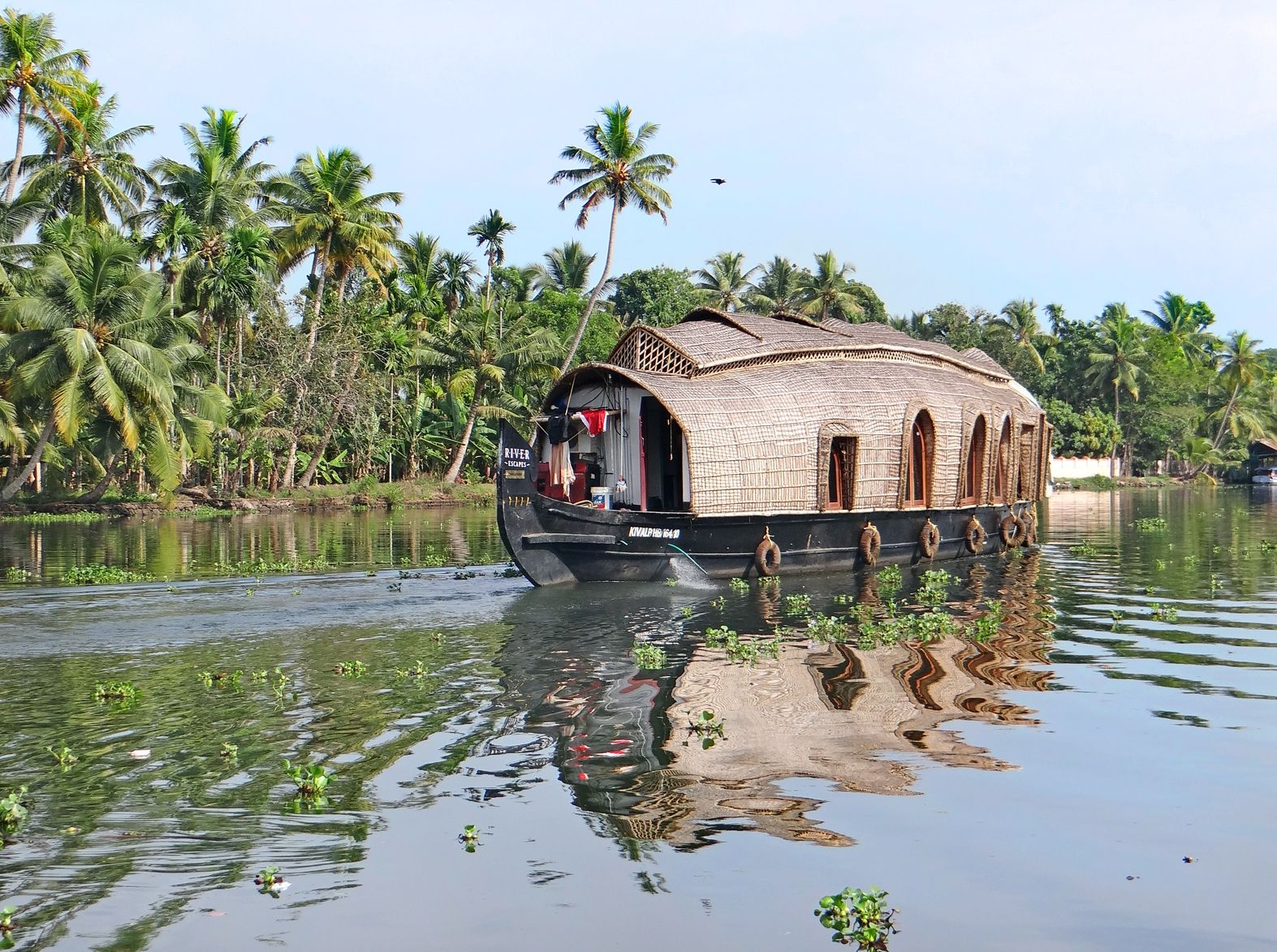
It is one of the few great landscapes best seen at walking pace from the water. A night on a converted kettuvallam rice barge takes you through villages where the canal is the street, past fishermen working Chinese dip nets and paddies lying below the waterline. Smaller canoes reach the narrow channels the houseboats cannot enter, which is where the backwaters are quietest and most interesting.
What to know before you go
🗓️ Best time
Roughly November to February, when the monsoon has passed, humidity drops and the waterways are full but calm. The snake-boat races fall around late summer. June to September brings the southwest monsoon — dramatic, very wet, and much less comfortable on an open boat.
🧭 Getting there & access
Fly into Kochi (COK) or Trivandrum (TRV). Alappuzha (Alleppey) and Kumarakom are the main houseboat bases, both a couple of hours by road or train from Kochi. Houseboats are booked through operators; public ferries run the same routes far more cheaply.
Good to know
- Take a small canoe or shikara for the narrow canals — the big houseboats are restricted to the wider channels.
- The state ferry between Alappuzha and Kottayam covers similar water for a tiny fraction of a houseboat fare.
- Ask whether your houseboat has a proper sewage holding tank; waste handling varies a great deal between operators.
- Book upper-deck or open-sided boats for airflow — the enclosed ones get very warm.
Plan your visit
Easy🧭 Getting there
From Kochi (COK), Kerala, India
- Fly into Kochi or Trivandrum
- Travel about 1.5–2 hours by road or train to Alappuzha or Kumarakom
- Board a houseboat, or take the public ferry for the same water
- Switch to a canoe for the narrow village canals
- Total travel
- Half a day from Kochi to the water
- Time at site
- One or two nights afloat; longer if you add the coast or the Ghats
- Access
- No permits. Houseboats are booked commercially and moor overnight rather than cruising after dark. Public ferries run fixed routes on published timetables and are open to anyone.
🎒 What to bring & consider
- Serious insect repellent — the canals are mosquito country at dusk
- Light cotton clothing for high humidity, plus something for sun on open decks
- Cash in rupees for ferries, canoes and village purchases
- Motion-free but slow travel; nothing here happens quickly
- Drinking water, since tap water is not potable
👁️ What to expect
- Crowds
- The Alappuzha houseboat fleet is genuinely large and the main channels get congested at peak season. The smaller canals are calm.
- Conditions
- Hot, humid and flat. Water everywhere. Mosquitoes at dawn and dusk.
- Facilities
- Extensive in Alappuzha and Kumarakom; the houseboats carry their own crew, cooking and bedding.
- The view
- Chinese dip nets silhouetted at sunset, or dawn mist lifting off Vembanad before the fleet moves.
Times and requirements are approximate and change with season, weather, and local rules — confirm permits, fares, and schedules with operators before you travel.
Natural riches of the area
- A ~900 km connected network of lagoons, lakes, rivers and canals
- Vembanad, the longest lake in India, at around 2,000 km²
- Barrier islands built by wave action across the river mouths
- Brackish estuarine habitat supporting migratory waterbirds and shellfish
- Below-sea-level paddy farmland reclaimed behind bunds
Local food
- Karimeen pollichathu
- Pearl spot fish from the backwaters, spiced and grilled in a banana leaf.
- Appam with stew
- Lacy fermented rice pancakes with a mild coconut-milk stew.
- Kerala fish curry
- Soured with kudampuli, the Malabar tamarind, and thickened with coconut.
- Toddy
- Fresh-tapped coconut palm sap, mildly fermented and drunk the same day.
Kerala’s backwaters are what happens when a coastline cannot decide which way sediment should go. Rivers come down fast off the Western Ghats carrying silt toward the Arabian Sea; waves and longshore drift push it straight back and heap it into low barrier islands across the river mouths. Blocked from the open sea, the water spreads sideways instead — into a connected web of lagoons, lakes and channels running roughly 900 kilometres, close to half the length of the state’s coast.
The water is brackish, and its salinity shifts with the tide and the season, which gives the system an ecology that belongs to neither river nor sea. At its centre lies Vembanad, India’s longest lake, held back from the ocean by a strip of land narrow enough to walk across. People have been farming the margins for centuries: paddy fields sit below sea level behind earth bunds, ducks are herded along the channels, and coconut husk is soaked in the shallows to make coir. The classic way through is a night on a kettuvallam, a rice barge converted to carry passengers — though the state ferries cover much of the same water for a few rupees, and a canoe will get you into the narrow village canals where the big boats cannot follow.
Kerala Backwaters: common questions
How do you get to Kerala Backwaters?
From Kochi (COK), Kerala, India: Fly into Kochi or Trivandrum; Travel about 1.5–2 hours by road or train to Alappuzha or Kumarakom; Board a houseboat, or take the public ferry for the same water; Switch to a canoe for the narrow village canals. Total travel time: Half a day from Kochi to the water.
When is the best time to visit Kerala Backwaters?
Roughly November to February, when the monsoon has passed, humidity drops and the waterways are full but calm. The snake-boat races fall around late summer. June to September brings the southwest monsoon — dramatic, very wet, and much less comfortable on an open boat.
How long should you spend at Kerala Backwaters?
One or two nights afloat; longer if you add the coast or the Ghats. Total travel time: Half a day from Kochi to the water.
What should you bring to Kerala Backwaters?
Serious insect repellent — the canals are mosquito country at dusk Light cotton clothing for high humidity, plus something for sun on open decks Cash in rupees for ferries, canoes and village purchases Motion-free but slow travel; nothing here happens quickly Drinking water, since tap water is not potable
Do you need a permit or guide for Kerala Backwaters?
No permits. Houseboats are booked commercially and moor overnight rather than cruising after dark. Public ferries run fixed routes on published timetables and are open to anyone.
Is Kerala Backwaters crowded, and what are conditions like?
The Alappuzha houseboat fleet is genuinely large and the main channels get congested at peak season. The smaller canals are calm. Hot, humid and flat. Water everywhere. Mosquitoes at dawn and dusk. Facilities: Extensive in Alappuzha and Kumarakom; the houseboats carry their own crew, cooking and bedding.
Added
More wonders to explore