Timanfaya National Park
📍 South-west Lanzarote, Canary Islands, Spain, in the municipalities of Yaiza and Tinajo
A 51 km² national park of lava fields and volcanic cones on Lanzarote, formed by historic eruptions — the great outpouring of 1730–1736 and the island's last eruption in 1824 — where the ground just below the surface still reaches hundreds of degrees.
What makes it marvelous
Timanfaya is the product of two historic eruptive episodes. The longest and most intense ran from 1730 to 1736 and covered a total of 195.2 km² of Lanzarote, building lines of volcanic cones along fractures running east-north-east to west-south-west. The second, in 1824, was the last eruption on the island and built three new cones, of which only one, El Chinero (Volcán Nuevo del Fuego), lies within the park. Spain's national parks agency describes it as the best example of recent volcanism in the Canary Islands: 'aa' and 'pahoehoe' lava fields with islands of older land left standing in them, volcanic cones and tubes, and caves. The heat has not gone. A residual magma chamber 4 to 5 km down produces geothermal anomalies, with temperatures of up to 610°C measured just 13 m below the surface and 100–200°C at ground level. With annual rainfall of no more than 125 mm and no tree cover, the lava is colonised mainly by lichens, close to 200 kinds of them.
Why visit
Ride the Ruta de los Volcanes through a sea of black and rust-red lava and cinder cones, watch the geothermal demonstrations at Islote de Hilario, where heat from a shallow magma chamber reaches the surface, and walk a guided trail across lava that is less than three centuries old.
Still deciding?
Timanfaya National Park comes up most often against one other place — each one weighs cost, effort, season and crowds side by side.
What to know before you go
🗓️ Best time
The park can be visited all year. Rain is scarce — annual rainfall is no more than 125 mm — and sunshine is strong, with large swings in temperature between day and night. Guided walks need booking in advance, so plan ahead in busy holiday periods.
🧭 Getting there & access
The LZ-67 road between Yaiza and Tinajo runs through the park and links its facilities. The Ruta de los Volcanes is entered from the Taro entrance building on the LZ-67, where the entry ticket covers parking, the geothermal demonstrations and a coach tour of the volcano route that starts from Islote de Hilario — the route can be seen only by coach. The Mancha Blanca Visitor Centre, at km 11.5 of the LZ-67 in Tinajo, is free. Most of the park is a strict reserve: visitors may not leave their vehicles except at designated car parks or walk on the lava outside marked trails.
Good to know
- Start at the free Mancha Blanca Visitor Centre, which explains the eruptions with exhibits and audiovisuals.
- Book the guided Tremesana walk, about 2 km, in advance through the Mancha Blanca Visitor Centre.
- Do not walk on the lava or pyroclastic ground outside permitted areas, and stop only in designated car parks.
- Camping, picnicking, fires, kites, gas balloons, hang-gliding, paragliding and pets are not allowed in the park.
Plan your visit
Easy🧭 Getting there
From Lanzarote (ACE), Canary Islands
- Fly to Lanzarote
- Drive to Yaiza or Tinajo and join the LZ-67, which crosses the park
- Stop at the Mancha Blanca Visitor Centre, then continue to the Taro entrance for the Ruta de los Volcanes coach tour from Islote de Hilario
- Total travel
- Lanzarote is a small island; the park lies in its south-west, between Yaiza and Tinajo
- Time at site
- Half a day for the visitor centre, the geothermal demonstrations and the Ruta de los Volcanes; a full day with the guided Tremesana walk or the coastal path
- Access
- The Ruta de los Volcanes is visited only by coach, with an entry ticket bought at the Taro entrance on the LZ-67 — confirm current prices and times with the national park (Organismo Autónomo Parques Nacionales, miteco.gob.es) and the operator at Islote de Hilario. The Mancha Blanca Visitor Centre is free. The guided Tremesana walk requires advance booking through the visitor centre. Leaving vehicles outside designated car parks and walking on the lava are prohibited.
🎒 What to bring & consider
- Sun protection and water — there is little shade on the lava
- Comfortable walking shoes for the guided trails
- A booking for the Tremesana walk if you want to walk inside the park
👁️ What to expect
- Crowds
- The coach route and Islote de Hilario are the park's busiest spots; the guided walks run in small groups.
- Conditions
- Paved road and a coach tour through the lava fields; guided walks on marked trails over volcanic ground.
- Facilities
- Mancha Blanca Visitor Centre with exhibitions and a shop; car parking and the geothermal demonstrations at Islote de Hilario.
- The view
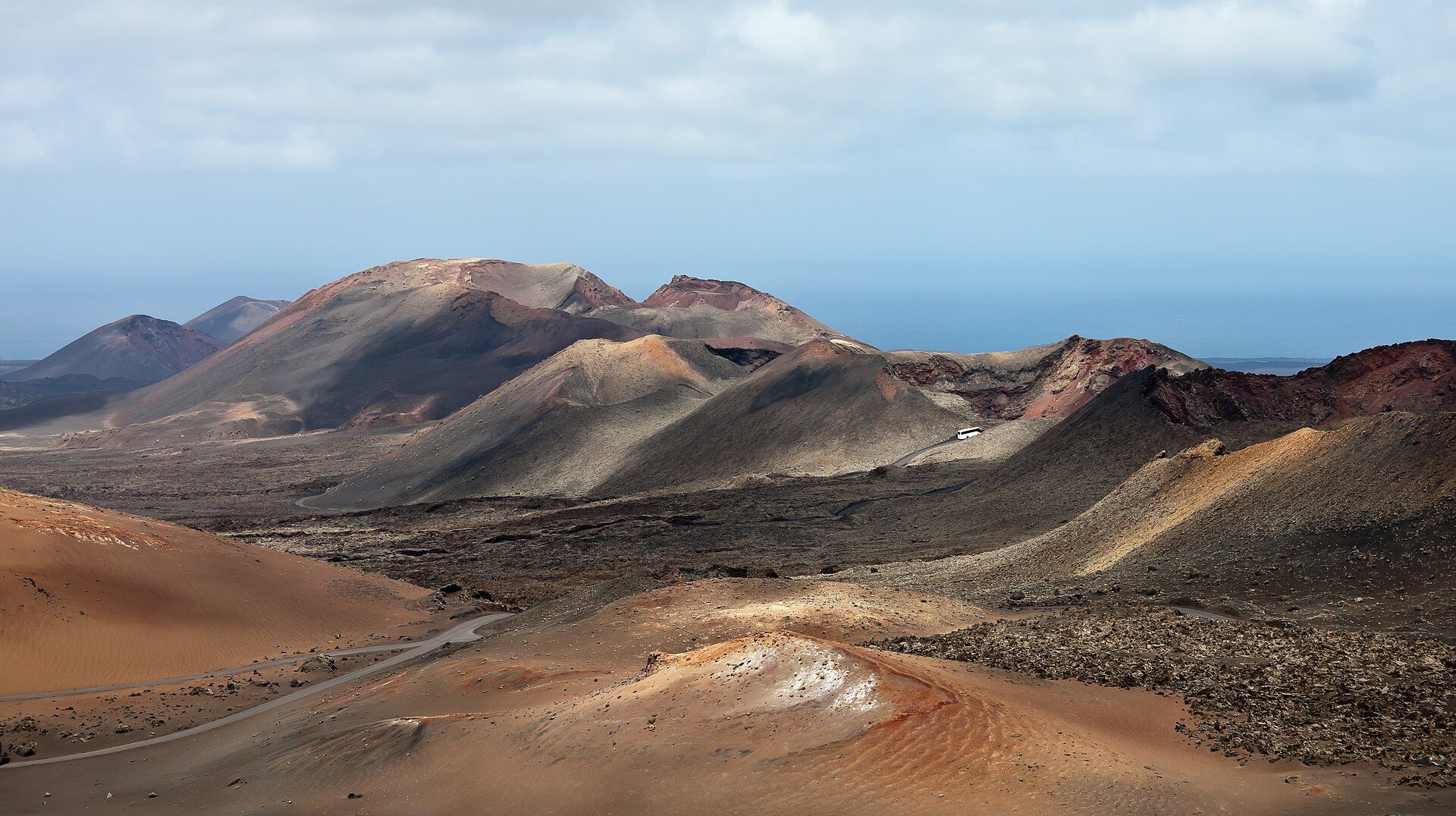
- Rust-red and black cinder cones rising out of a rough lava field under a hard blue Canary sky.
Times and requirements are approximate and change with season, weather, and local rules — confirm permits, fares, and schedules with operators before you travel.
Natural riches of the area
- Lava fields of the 1730–1736 eruptions, both 'aa' and 'pahoehoe'
- Volcanic cones including Montaña de Timanfaya, Montaña Rajada, Caldera del Corazoncillo and El Chinero
- Geothermal anomalies at Islote de Hilario
- Close to 200 kinds of lichen colonising the lava
- A wild coastline of cliffs with the Playa del Cochino and Playa del Paso beaches
- The Haría lizard, which the park describes as endemic to Lanzarote
Local food
- Papas arrugadas con mojo
- Canarian salt-crusted 'wrinkled' potatoes served with red and green mojo sauces.
- Lanzarote Malvasía wine
- White wine from vines grown in Lanzarote's volcanic soils, as in the La Geria valley seen from the park.
- Gofio
- Roasted grain meal, a Canarian staple used in soups, desserts and dough.
Timanfaya National Park covers 51 square kilometres of south-west Lanzarote, in the municipalities of Yaiza and Tinajo. Spain made it a national park in 1974, and Spain’s national parks agency describes it as the best example of recent volcanism in the Canary Islands. Almost nothing here is old. Black and rust-red cinder cones rise out of rough lava fields, and over 90 percent of the park is a reserve zone closed to visitors.
Two eruptions built it. The first and greater one began in 1730 and lasted until 1736, spreading lava over a total of 195.2 square kilometres of the island and raising lines of cones along fractures in the crust. A second, in 1824, was the last eruption on Lanzarote; of its three new cones, only El Chinero lies inside the park. Between them they left fields of jagged “aa” lava and smoother “pahoehoe,” with islands of older land standing in them, along with volcanic tubes and caves.
The heat is still close to the surface. A residual magma chamber 4 to 5 kilometres down keeps the ground hot: temperatures of up to 610°C have been measured just 13 metres below the surface, and 100 to 200°C at ground level. Visitors see this at Islote de Hilario, where geothermal demonstrations show what the shallow heat can do. Life is slow to return to the lava with no more than 125 millimetres of rain a year. Lichens came first and now cover much of the volcanic surface, with close to 200 kinds recorded. The park is also the only national park in the Canaries that takes in a stretch of coast.
Visits are tightly managed. The Ruta de los Volcanes can be seen only by coach, from the Taro entrance on the LZ-67. The free Mancha Blanca Visitor Centre explains the eruptions and takes bookings for the guided Tremesana walk, about 2 kilometres, which must be reserved in advance. Stay on the paved areas and marked trails, and confirm current prices and times with the park before you go.
Timanfaya National Park: common questions
How do you get to Timanfaya National Park?
From Lanzarote (ACE), Canary Islands: Fly to Lanzarote; Drive to Yaiza or Tinajo and join the LZ-67, which crosses the park; Stop at the Mancha Blanca Visitor Centre, then continue to the Taro entrance for the Ruta de los Volcanes coach tour from Islote de Hilario. Total travel time: Lanzarote is a small island; the park lies in its south-west, between Yaiza and Tinajo.
When is the best time to visit Timanfaya National Park?
The park can be visited all year. Rain is scarce — annual rainfall is no more than 125 mm — and sunshine is strong, with large swings in temperature between day and night. Guided walks need booking in advance, so plan ahead in busy holiday periods.
How long should you spend at Timanfaya National Park?
Half a day for the visitor centre, the geothermal demonstrations and the Ruta de los Volcanes; a full day with the guided Tremesana walk or the coastal path. Total travel time: Lanzarote is a small island; the park lies in its south-west, between Yaiza and Tinajo.
What should you bring to Timanfaya National Park?
Sun protection and water — there is little shade on the lava Comfortable walking shoes for the guided trails A booking for the Tremesana walk if you want to walk inside the park
Do you need a permit or guide for Timanfaya National Park?
The Ruta de los Volcanes is visited only by coach, with an entry ticket bought at the Taro entrance on the LZ-67 — confirm current prices and times with the national park (Organismo Autónomo Parques Nacionales, miteco.gob.es) and the operator at Islote de Hilario. The Mancha Blanca Visitor Centre is free. The guided Tremesana walk requires advance booking through the visitor centre. Leaving vehicles outside designated car parks and walking on the lava are prohibited.
Is Timanfaya National Park crowded, and what are conditions like?
The coach route and Islote de Hilario are the park's busiest spots; the guided walks run in small groups. Paved road and a coach tour through the lava fields; guided walks on marked trails over volcanic ground. Facilities: Mancha Blanca Visitor Centre with exhibitions and a shop; car parking and the geothermal demonstrations at Islote de Hilario.
Added