Bay of Kotor
📍 Boka Kotorska, Adriatic coast of Montenegro
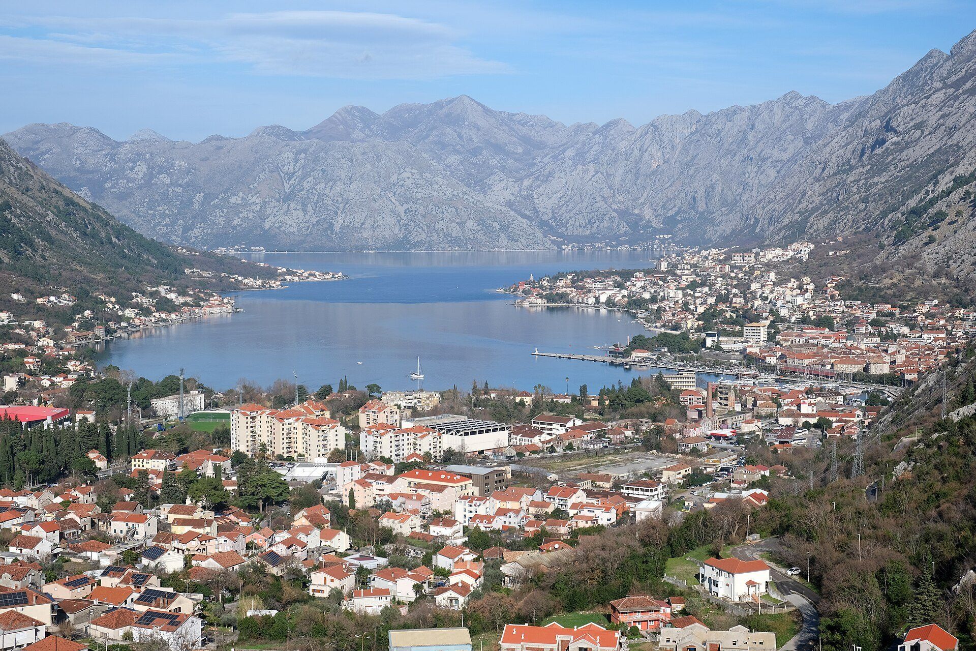
A winding Adriatic inlet where limestone mountains rise more than a kilometre almost straight from the water, its inner bays — past the Verige strait — ringing the walled town of Kotor, Perast and Risan. A UNESCO World Heritage site since 1979.
What makes it marvelous
The Bay of Kotor is what happens where the Dinaric limestone meets the Adriatic head-on. The sea reaches deep inland in a chain of linked bays, pinched in the middle by the narrow Verige strait, and on the inner side the mountains climb so steeply that the shoreline towns are squeezed onto a strip of flat land at the water's edge. The inner bay, from Verige to Kotor, Perast and Risan, is a UNESCO World Heritage site (1979, about 14,600 hectares with a 36,491-hectare buffer zone): the old town of Kotor sits at the very back of it, and its Venetian walls zigzag straight up the mountainside behind to the fortress of St John, more than 260 metres above the sea. Two islets off Perast, Sveti Đorđe and Gospa od Škrpijela, are part of the protected area. The setting has a fragile side too: a strong earthquake on 15 April 1979 badly damaged Kotor, and the site stayed on UNESCO's List of World Heritage in Danger until 2003.
Why visit
Few places put the sea and the mountains this close together. Climb Kotor's walls for the view down the inner bay, drive or boat the shoreline to Perast and its two islets, and cross the Verige strait by ferry with the peaks closing in on both sides.
Still deciding?
Bay of Kotor comes up most often against these — each one weighs cost, effort, season and crowds side by side.
What to know before you go
🗓️ Best time
May and October are quieter and still comfortable; July and August are the busiest months on the coast.
🧭 Getting there & access
The bay is on Montenegro's coast, with Tivat airport on the coast and Podgorica airport inland. The Adriatic Highway follows the shore; traffic crosses the Verige strait by car ferry. Kotor's old town is walkable, and the climb to the fortress of St John starts from inside the walls.
Good to know
- Climb the walls early in the morning — the path is steep, exposed and hot by midday.
- Base yourself in Perast or another small shore village for quieter evenings than Kotor's old town.
- Distances look short but the coast road is slow; allow plenty of time.
Natural riches of the area
- A deep, sheltered Adriatic inlet pinched by the Verige strait
- Limestone mountains rising more than a kilometre within sight of the water
- Two islets off Perast within the protected area
Local food
- Grilled Adriatic fish
- The coast eats Mediterranean — grilled fish with olive oil is the default order along the bay.
- Squid-ink risotto
- Black risotto is a coastal staple in Montenegro.
- Njeguši ham
- Smoked and air-dried in the village of Njeguši, in the mountains above Kotor.
The Bay of Kotor is the place where Montenegro’s limestone mountains meet the Adriatic with almost no warning. The sea runs far inland in a chain of linked bays, squeezed in the middle by the narrow Verige strait, and on the inner side the mountains rise so steeply that the towns cling to a thin strip of shore.
The inner bay is a UNESCO World Heritage site, inscribed in 1979. At its far end, Kotor’s old town is wrapped in Venetian-era walls that climb the mountainside behind it to the fortress of St John, more than 260 metres above the water — the climb gives the classic view straight down the bay. Along the shore, Perast looks out at two small islets, and Risan sits in its own inner bay. The same year the site was listed, an earthquake badly damaged Kotor; after years of rebuilding it came off UNESCO’s danger list in 2003.
Bay of Kotor: common questions
When is the best time to visit Bay of Kotor?
May and October are quieter and still comfortable; July and August are the busiest months on the coast.
How do you get to Bay of Kotor?
The bay is on Montenegro's coast, with Tivat airport on the coast and Podgorica airport inland. The Adriatic Highway follows the shore; traffic crosses the Verige strait by car ferry. Kotor's old town is walkable, and the climb to the fortress of St John starts from inside the walls.
Added