Mount Ushba
📍 Upper Svaneti, Greater Caucasus, Georgia
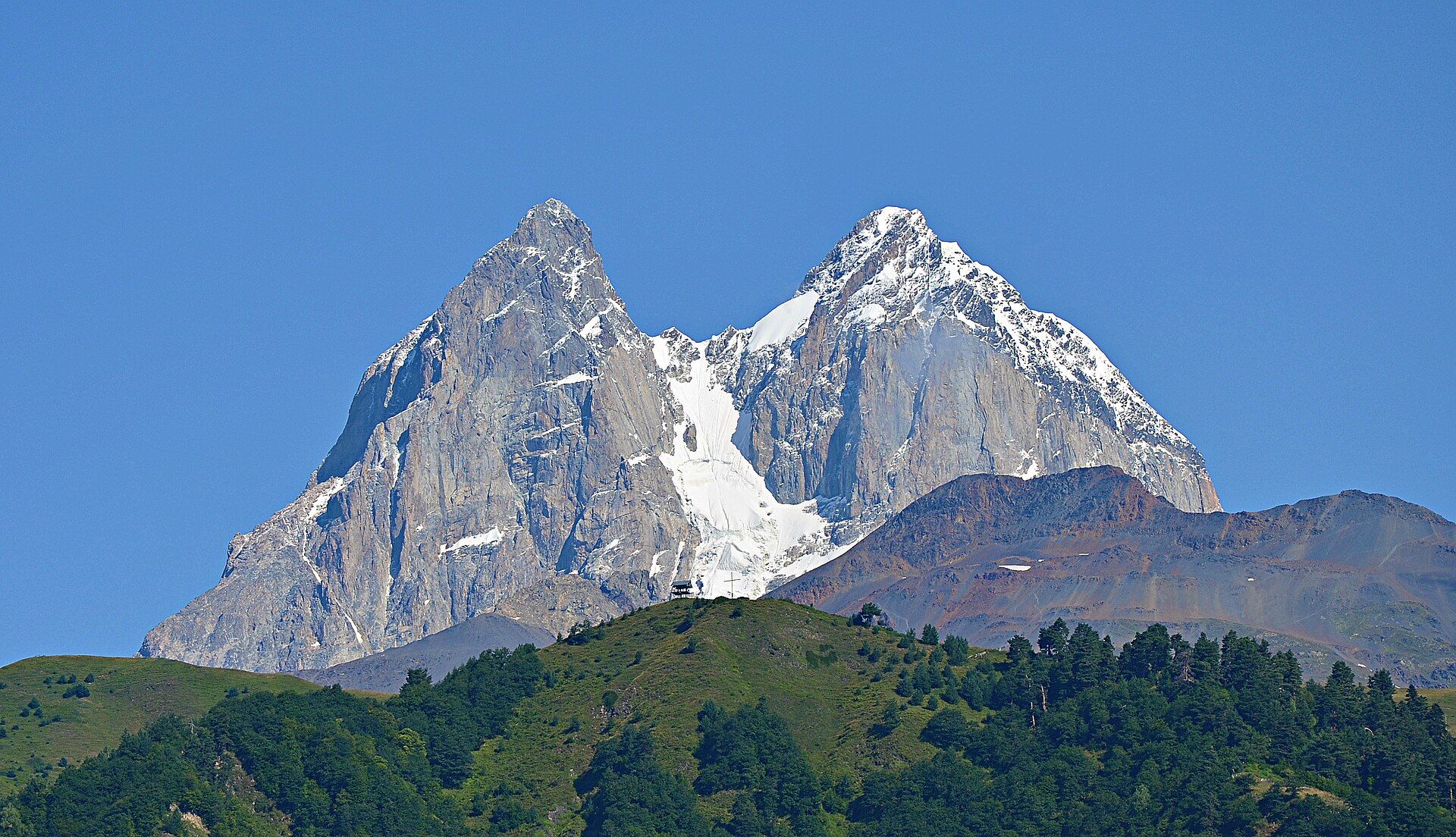
The twin-horned peak that dominates Georgian Svaneti — 4,710 metres of granite and hanging ice known as the Matterhorn of the Caucasus, and widely held to be the hardest serious climb in the range.
What makes it marvelous
Ushba is not the highest mountain in the Caucasus, and that is rather the point: it is the one everybody recognises. Two summits stand side by side, the southern at 4,710 metres and the northern at 4,690, separated by the Ushba Icefall — a profile so sheer and symmetrical that it earned the nickname Matterhorn of the Caucasus. The south summit carries a complicated apron of hanging glaciers and permanent snowfields that peel off its faces, and the combination of steep granite, serious altitude and famously unstable weather has made Ushba the mountain Caucasus climbers rate as the hardest technical ascent in the range, well above peaks that are considerably taller. For everyone else it is a backdrop: the whole of Upper Svaneti is arranged around the sight of it, and the valley walks below the Ushba Glacier put you underneath the north face without a rope in sight.
Why visit
Svaneti is the most dramatic mountain country in Georgia, and Ushba is what makes it look the way it does. From the villages around Mestia and Mazeri the twin summits rise out of forested valleys with startling abruptness, and the day walks toward the Ushba Glacier and the Shdugra waterfall get you close to serious mountain terrain on ordinary legs.
What to know before you go
🗓️ Best time
Roughly June to September, when the high passes are clear, the valley trails are walkable and the guesthouses in Mestia and Mazeri are open. Snow closes much of the region from late autumn, and the road up from the lowlands can be difficult in winter.
🧭 Getting there & access
Fly or drive to Kutaisi or Zugdidi, then take the mountain road up to Mestia — a spectacular but slow 3–4 hours from Zugdidi. Mazeri and Becho, directly beneath the peak, are a further short drive. Valley walking needs no permit; the mountain itself is a technical climb requiring a qualified guide.
Good to know
- Base in Mestia for services or Mazeri for the closest views of the north face.
- Walk the Shdugra waterfall and Ushba Glacier trails from Mazeri for the best low-level angles.
- Cloud swallows the summits for days at a time — allow more than one clear morning.
- Marshrutka minibuses run to Mestia but fill early; a shared car is more reliable.
Plan your visit
Moderate🧭 Getting there
From Kutaisi (KUT) or Zugdidi, Georgia
- Fly into Kutaisi or Tbilisi
- Travel to Zugdidi by road or overnight train
- Drive the mountain road up to Mestia — roughly 3–4 hours
- Continue by car to Mazeri or Becho, directly under the north face
- Total travel
- A full travel day from Tbilisi to Svaneti
- Time at site
- 3–4 days, to allow for cloud and to walk more than one valley
- Access
- No permit for valley walking or the glacier approach trails. The summits are a serious technical climb needing a qualified guide and mountaineering experience. The road to Mestia is paved but long and winding; landslides occasionally close it.
🎒 What to bring & consider
- Proper hiking boots — the glacier approach is rough, loose and often wet
- Layers and a windproof shell; weather at this altitude changes within the hour
- Cash in lari, as card acceptance in the mountain villages is patchy
- Downloaded maps, since mobile coverage drops out in the side valleys
- Spare days in the plan for cloud that refuses to lift
👁️ What to expect
- Crowds
- Mestia is busy in high summer; the Mazeri side and the upper valleys stay quiet.
- Conditions
- Steep alpine valleys, rough trails, and fast-changing mountain weather. Cool even in August at altitude.
- Facilities
- Guesthouses, cafes and guides in Mestia and Mazeri; nothing on the trails themselves.
- The view
- The twin summits catching first light from the Mazeri side, before the daily cloud builds over the icefall.
Times and requirements are approximate and change with season, weather, and local rules — confirm permits, fares, and schedules with operators before you travel.
Natural riches of the area
- A 4,710 m twin-summit granite massif in the Greater Caucasus
- Hanging glaciers and the Ushba Icefall between the two summits
- The Ushba Glacier and Shdugra waterfall in the valleys below
- Beech and conifer forest rising to alpine meadow on the approach slopes
Local food
- Kubdari
- The Svan meat pie — spiced beef or pork baked inside bread, the signature dish of these mountains.
- Svan salt
- A herb-and-garlic salt blend from the region, used on almost everything.
- Tashmijabi
- Mashed potato beaten with molten mountain cheese until it pulls into strands.
- Matsoni
- Thick soured milk eaten across Georgia, made locally from cow's milk.
Upper Svaneti is arranged around one mountain. Ushba is not the highest peak in the Caucasus — several exceed it comfortably — but it is the one that defines the skyline, because instead of a broad snow dome it throws up two granite horns side by side, the southern at 4,710 metres and the northern twenty metres lower, split by a chaotic icefall. The resemblance to a certain Alpine peak got it the name Matterhorn of the Caucasus, and it is earned.
That shape has consequences. Hanging glaciers cling to the south summit’s faces and shed without warning, the granite is steep enough to stay bare, and the weather over Svaneti changes faster than almost anywhere in the range. Climbers generally rate Ushba the hardest serious ascent in the Caucasus, harder than peaks several hundred metres taller. None of which matters if you have come to look at it rather than climb it: the trails out of Mazeri toward the Ushba Glacier and the Shdugra waterfall run right underneath the north face, through beech forest and alpine meadow, and ask nothing more of you than a decent pair of boots and the patience to wait out the cloud.
Mount Ushba: common questions
How do you get to Mount Ushba?
From Kutaisi (KUT) or Zugdidi, Georgia: Fly into Kutaisi or Tbilisi; Travel to Zugdidi by road or overnight train; Drive the mountain road up to Mestia — roughly 3–4 hours; Continue by car to Mazeri or Becho, directly under the north face. Total travel time: A full travel day from Tbilisi to Svaneti.
When is the best time to visit Mount Ushba?
Roughly June to September, when the high passes are clear, the valley trails are walkable and the guesthouses in Mestia and Mazeri are open. Snow closes much of the region from late autumn, and the road up from the lowlands can be difficult in winter.
How long should you spend at Mount Ushba?
3–4 days, to allow for cloud and to walk more than one valley. Total travel time: A full travel day from Tbilisi to Svaneti.
What should you bring to Mount Ushba?
Proper hiking boots — the glacier approach is rough, loose and often wet Layers and a windproof shell; weather at this altitude changes within the hour Cash in lari, as card acceptance in the mountain villages is patchy Downloaded maps, since mobile coverage drops out in the side valleys Spare days in the plan for cloud that refuses to lift
Do you need a permit or guide for Mount Ushba?
No permit for valley walking or the glacier approach trails. The summits are a serious technical climb needing a qualified guide and mountaineering experience. The road to Mestia is paved but long and winding; landslides occasionally close it.
Is Mount Ushba crowded, and what are conditions like?
Mestia is busy in high summer; the Mazeri side and the upper valleys stay quiet. Steep alpine valleys, rough trails, and fast-changing mountain weather. Cool even in August at altitude. Facilities: Guesthouses, cafes and guides in Mestia and Mazeri; nothing on the trails themselves.
Added
More wonders to explore