Trolltunga
📍 Vestland, western Norway
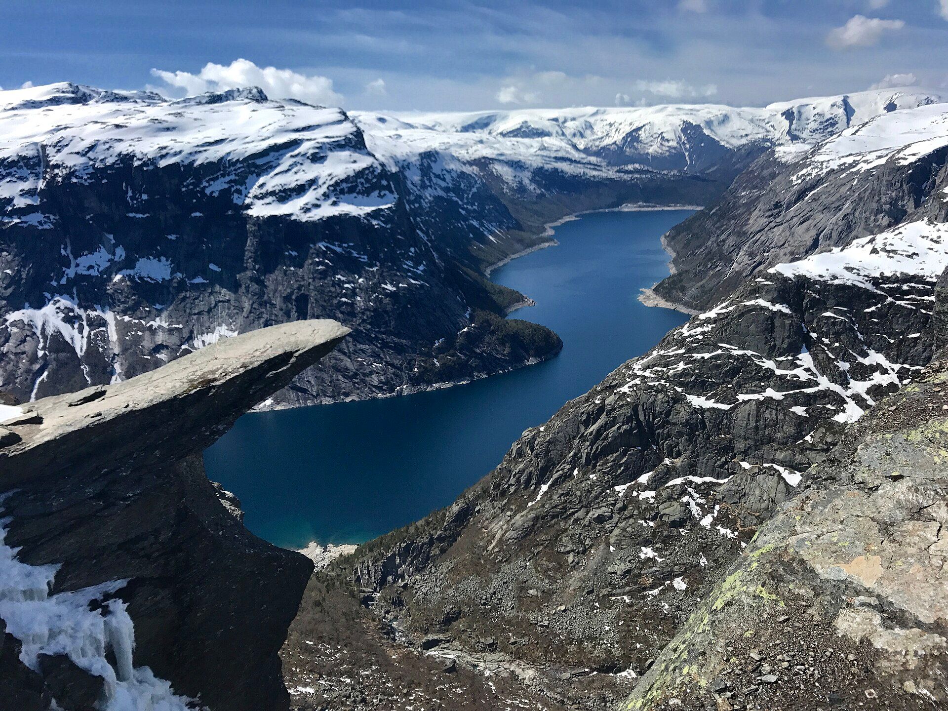
The 'Troll's Tongue' — a thin slab of rock jutting horizontally into empty air some 700 metres above a fjord lake, at the end of one of Norway's most demanding day hikes.
What makes it marvelous
Trolltunga is a startling piece of geology: a flat shelf of gneiss that juts straight out from the cliff face like a tongue, hanging in mid-air roughly 700 metres above Lake Ringedalsvatnet. It was left behind at the end of the last Ice Age, when a glacier plucked away the rock beneath and along the natural fractures, leaving this improbable slab cantilevered over the void. Reaching it is part of the experience: a long, strenuous mountain hike of roughly 27 kilometres round trip with about 800 metres of climbing, across high plateau, snow patches, and bare rock, typically taking eight to twelve hours. The reward is a view down a glacier-carved valley to the water far below — and the chance to stand, if you dare, on the tongue itself.
Why visit
Earning the view with a long mountain hike and then stepping onto a slab of rock suspended 700 metres above a fjord lake is one of the most exhilarating rewards in Norwegian hiking — a genuine test and a genuine spectacle.
Still deciding?
Trolltunga comes up most often against these — each one weighs cost, effort, season and crowds side by side.
What to know before you go
🗓️ Best time
Mid-June to mid-September, when the trail is largely snow-free and safe; outside that window the hike requires winter equipment and a guide, and is often closed.
🧭 Getting there & access
Above Odda and Tyssedal in western Norway; the hike starts from car parks at Skjeggedal or Mågelitopp, with shuttle options in summer. It is a full-day, high-mountain hike.
Good to know
- Only attempt in summer without a guide; snow makes it hazardous otherwise.
- Start very early — it's 8–12 hours round trip; carry food, water, and layers.
- Norwegian mountain weather turns fast; check forecasts and turn back if needed.
Plan your visit
Strenuous🧭 Getting there
From Odda, Norway
- Fly → Bergen (BGO), then drive Bergen → Odda — roughly 3h
- Drive Odda → the Skjeggedal car park — about 20 minutes
- Shuttle up to the Mågelitopp car park to cut the climb, or walk from Skjeggedal
- Hike to Trolltunga and back — roughly 8–12 hours depending on where you start
- Total travel
- Half a day from Bergen to the trailhead
- Time at site
- A very long day on the mountain
- Access
- Open access with parking charges that vary by car park and season. The unguided season is short — broadly mid-June to mid-September — and outside it a guide is required because the route is snow-covered, the markers are buried and navigation is genuinely hard. This trail generates a steady stream of mountain rescue callouts from people who started too late, ran out of daylight or underestimated 28 kilometres and 800 metres of ascent. Check current conditions and the season status with the local trail authority before setting out.
🎒 What to bring & consider
- An honest assessment of the distance: this is a full mountain day of 10 to 12 hours from the lower car park, and the single most common reason for rescue here is people treating it as a walk to a viewpoint
- A start before dawn, and a turnaround time you will actually honour
- Full mountain kit — waterproofs, warm layers, boots, headtorch, food and water — because the plateau has no shelter and weather closes in fast
- A charged phone kept warm, plus a paper map, since the plateau looks identical in cloud
- Patience for the queue at the tongue itself, which can run to an hour or more on a good summer day
👁️ What to expect
- Crowds
- Busy on the trail in July and August, and slow at the rock where everyone waits their turn for the photograph.
- Conditions
- Long, rocky, exposed high plateau with bogs, snow patches into summer and no shelter.
- Facilities
- Car parks, a shuttle and toilets at the bottom. Nothing at all on the route.
- The view
- A person standing out on the tongue above Ringedalsvatnet, which requires the queue, a steady hand from whoever is holding the camera, and no wind. Cloud in the valley below makes it, and cloud on the plateau ruins it.
Times and requirements are approximate and change with season, weather, and local rules — confirm permits, fares, and schedules with operators before you travel.
Natural riches of the area
- A glacier-plucked rock slab suspended ~700 m above the lake
- Glacier-carved fjord-lake valley scenery
- High mountain plateau, snowfields, and bare gneiss
- Classic Norwegian fjord-country geology
Local food
- Norwegian seafood
- Salmon, trout, and coastal shellfish from the fjords.
- Hardanger fruit & cider
- The nearby Hardanger region is famed for apples, cherries, and cider.
- Brunost & flatbread
- Sweet brown cheese and crispbread, classic Norwegian hiking food.
Trolltunga — ‘the Troll’s Tongue’ — is one of the strangest and most exhilarating rock formations in Norway: a flat slab of gneiss jutting horizontally out of the cliff face, hanging in empty air some 700 metres above Lake Ringedalsvatnet. It is a leftover of the last Ice Age, when a glacier plucked away the rock beneath and along the natural fractures, leaving this improbable shelf cantilevered over the void.
Getting there is half the story. The hike runs roughly 27 kilometres round trip with about 800 metres of ascent, crossing high plateau, snow patches, and bare rock, and takes most people eight to twelve hours. It is a serious mountain day, not a stroll. But the payoff — a view straight down a glacier-carved valley to the water far below, and the chance to walk out onto the tongue itself if your nerve holds — is among the most memorable rewards in all of Norwegian hiking.
Trolltunga: common questions
How do you get to Trolltunga?
From Odda, Norway: Fly → Bergen (BGO), then drive Bergen → Odda — roughly 3h; Drive Odda → the Skjeggedal car park — about 20 minutes; Shuttle up to the Mågelitopp car park to cut the climb, or walk from Skjeggedal; Hike to Trolltunga and back — roughly 8–12 hours depending on where you start. Total travel time: Half a day from Bergen to the trailhead.
When is the best time to visit Trolltunga?
Mid-June to mid-September, when the trail is largely snow-free and safe; outside that window the hike requires winter equipment and a guide, and is often closed.
How long should you spend at Trolltunga?
A very long day on the mountain. Total travel time: Half a day from Bergen to the trailhead.
What should you bring to Trolltunga?
An honest assessment of the distance: this is a full mountain day of 10 to 12 hours from the lower car park, and the single most common reason for rescue here is people treating it as a walk to a viewpoint A start before dawn, and a turnaround time you will actually honour Full mountain kit — waterproofs, warm layers, boots, headtorch, food and water — because the plateau has no shelter and weather closes in fast A charged phone kept warm, plus a paper map, since the plateau looks identical in cloud Patience for the queue at the tongue itself, which can run to an hour or more on a good summer day
Do you need a permit or guide for Trolltunga?
Open access with parking charges that vary by car park and season. The unguided season is short — broadly mid-June to mid-September — and outside it a guide is required because the route is snow-covered, the markers are buried and navigation is genuinely hard. This trail generates a steady stream of mountain rescue callouts from people who started too late, ran out of daylight or underestimated 28 kilometres and 800 metres of ascent. Check current conditions and the season status with the local trail authority before setting out.
Is Trolltunga crowded, and what are conditions like?
Busy on the trail in July and August, and slow at the rock where everyone waits their turn for the photograph. Long, rocky, exposed high plateau with bogs, snow patches into summer and no shelter. Facilities: Car parks, a shuttle and toilets at the bottom. Nothing at all on the route.
Added
More wonders to explore