Étretat Cliffs
📍 Étretat, Seine-Maritime, Normandy, France
White chalk cliffs on the Normandy coast carved into three natural arches and a lone needle of rock — the seascape Monet painted again and again.
What makes it marvelous
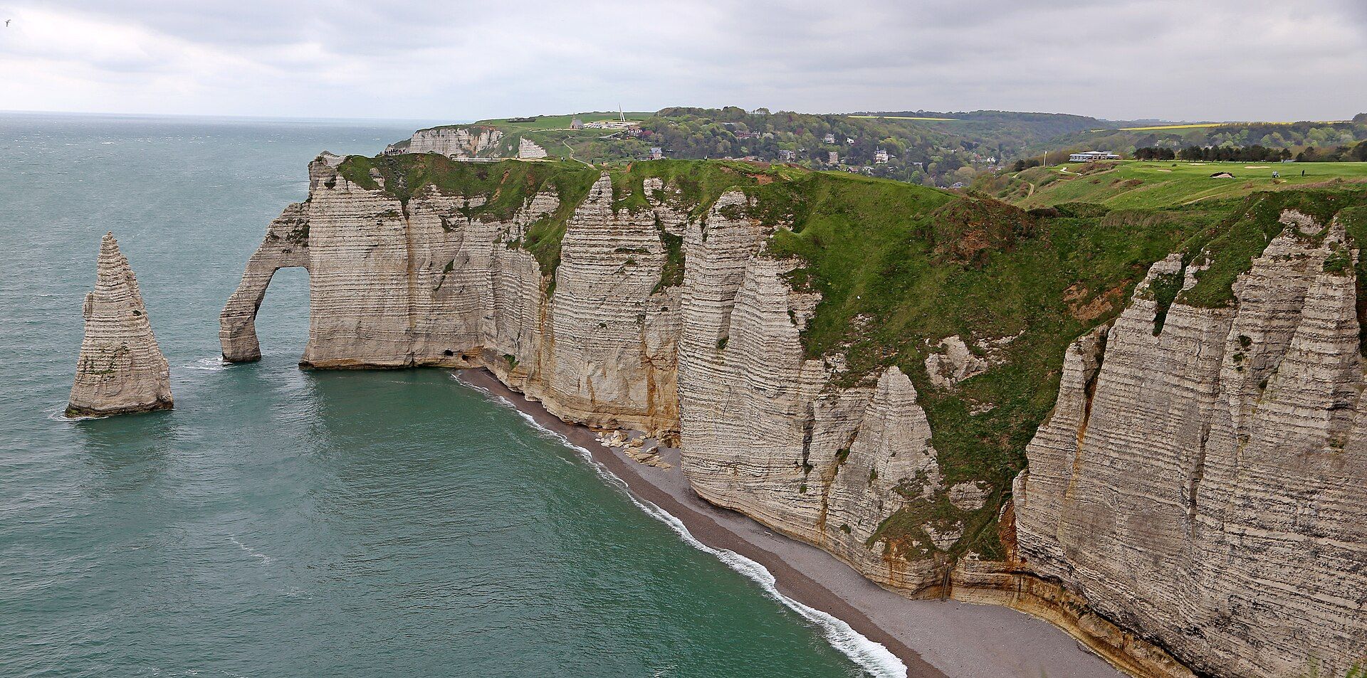
At Étretat the Channel has eaten into chalk cliffs up to about 90 m high, leaving behind three great arches — the Porte d'Aval, the Porte d'Amont and, largest of all, the Manneporte — and the Aiguille, a slender needle of chalk standing alone in the sea beside the Porte d'Aval. The pale rock, banded with dark flint, changes colour with every shift of light and weather.
Why visit
The clifftop paths on either side of the town give some of the most striking coastal views in Europe, and the scene carries a long artistic history: Monet, Courbet, Boudin and Daubigny all painted it, and Maurice Leblanc set his Arsène Lupin novel The Hollow Needle among these rocks.
What to know before you go
🗓️ Best time
Late spring to early autumn for clifftop walking and long evening light; winter storms are dramatic but the paths can be muddy and exposed.
🧭 Getting there & access
Étretat is a small town on the Normandy coast about 32 km northeast of Le Havre, reached by road or by bus from Le Havre. Paths climb to the cliffs from both ends of the pebble beach.
Good to know
- Stay back from the cliff edges — chalk crumbles and there are no barriers along most of the path.
- Check the tide before walking on the beach toward the arches; the rising sea cuts off the shore.
- Walk the Falaise d'Aval at sunset for the arch and needle together.
Plan your visit
Easy🧭 Getting there
From Le Havre, Normandy
- Train to Le Havre — about 2 hours from Paris
- Bus or drive northeast along the coast to Étretat, about 32 km
- Climb to the clifftop paths from either end of the beach
- Total travel
- About 3 hours from Paris
- Time at site
- Half a day to walk both cliffs; a full day with the GR 21 coastal path
- Access
- The clifftop paths are free and open. Much of the edge is unfenced and the chalk erodes; beach walks toward the arches depend on the tide.
🎒 What to bring & consider
- Walking shoes for grassy, sometimes muddy paths
- A windproof layer
- A tide table if exploring the beach
👁️ What to expect
- Crowds
- Busy on summer weekends and holidays; quiet early and late in the day.
- Conditions
- Windy, changeable Channel weather; paths slippery after rain.
- Facilities
- Cafés, restaurants and toilets in the town; none on the clifftops.
- The view
- The Porte d'Aval and the Aiguille from the Falaise d'Amont across the bay, or from above on the Falaise d'Aval.
Times and requirements are approximate and change with season, weather, and local rules — confirm permits, fares, and schedules with operators before you travel.
Natural riches of the area
- Chalk cliffs up to about 90 m high
- Three natural arches and the free-standing Aiguille
- A pebble beach and Channel seascape
Local food
- Moules marinières
- Mussels cooked in white wine, a staple of the Normandy coast.
- Normandy cider and Camembert
- The region's orchards and dairies supply both.
Étretat is a small Normandy resort that happens to sit beside one of the most famous coastlines in Europe. On either side of its pebble beach the land ends in white chalk cliffs, up to about 90 m high, that the sea has sculpted into arches. The Porte d’Aval to the west stands beside the Aiguille, a needle of chalk rising alone from the water; the Porte d’Amont closes the bay to the east; and beyond the Porte d’Aval, out of sight from the town, lies the largest arch of all, the Manneporte.
The cliffs have drawn painters for 150 years. Claude Monet painted the arches and stacks repeatedly in changing light, and Courbet, Boudin and Daubigny worked here too. Maurice Leblanc, who lived in Étretat, made the Aiguille the centre of his 1909 Arsène Lupin novel The Hollow Needle; his house is now the Clos Lupin museum.
The best way to see it is on foot. Paths climb onto both cliffs, part of the GR 21 coastal trail, giving views across the bay to the arches and down the coast. Keep well back from the crumbling edge, and if you walk the beach, know the tide.
Étretat Cliffs: common questions
How do you get to Étretat Cliffs?
From Le Havre, Normandy: Train to Le Havre — about 2 hours from Paris; Bus or drive northeast along the coast to Étretat, about 32 km; Climb to the clifftop paths from either end of the beach. Total travel time: About 3 hours from Paris.
When is the best time to visit Étretat Cliffs?
Late spring to early autumn for clifftop walking and long evening light; winter storms are dramatic but the paths can be muddy and exposed.
How long should you spend at Étretat Cliffs?
Half a day to walk both cliffs; a full day with the GR 21 coastal path. Total travel time: About 3 hours from Paris.
What should you bring to Étretat Cliffs?
Walking shoes for grassy, sometimes muddy paths A windproof layer A tide table if exploring the beach
Do you need a permit or guide for Étretat Cliffs?
The clifftop paths are free and open. Much of the edge is unfenced and the chalk erodes; beach walks toward the arches depend on the tide.
Is Étretat Cliffs crowded, and what are conditions like?
Busy on summer weekends and holidays; quiet early and late in the day. Windy, changeable Channel weather; paths slippery after rain. Facilities: Cafés, restaurants and toilets in the town; none on the clifftops.
Added
More wonders to explore