Mekong Delta
📍 Southwestern Vietnam
Some 40,000 square kilometres of river-built farmland where the Mekong finally reaches the sea — Vietnam's rice bowl, threaded by canals, and now sinking faster than the sea is rising.
What makes it marvelous
The delta is entirely a construction of the river. For millions of years the Mekong has carried sediment down from the Tibetan Plateau and dropped it here, building roughly 40,000 square kilometres of flat, extraordinarily fertile land barely above sea level. Vietnamese calls the river Cửu Long, the nine dragons, for the number of arms it once split into on the way to the sea; two have since silted up and the name has outlasted them. That sediment is the whole basis of the place — it rebuilds the farmland the sea erodes and supplies the nutrients that let the delta produce a very large share of Vietnam's rice. It is also what is now in short supply: upstream dams trap sediment before it arrives, groundwater extraction is causing the land itself to subside, and salt water is pushing further inland each dry season. The delta is a landscape you can watch responding to decisions made two thousand kilometres away.
Why visit
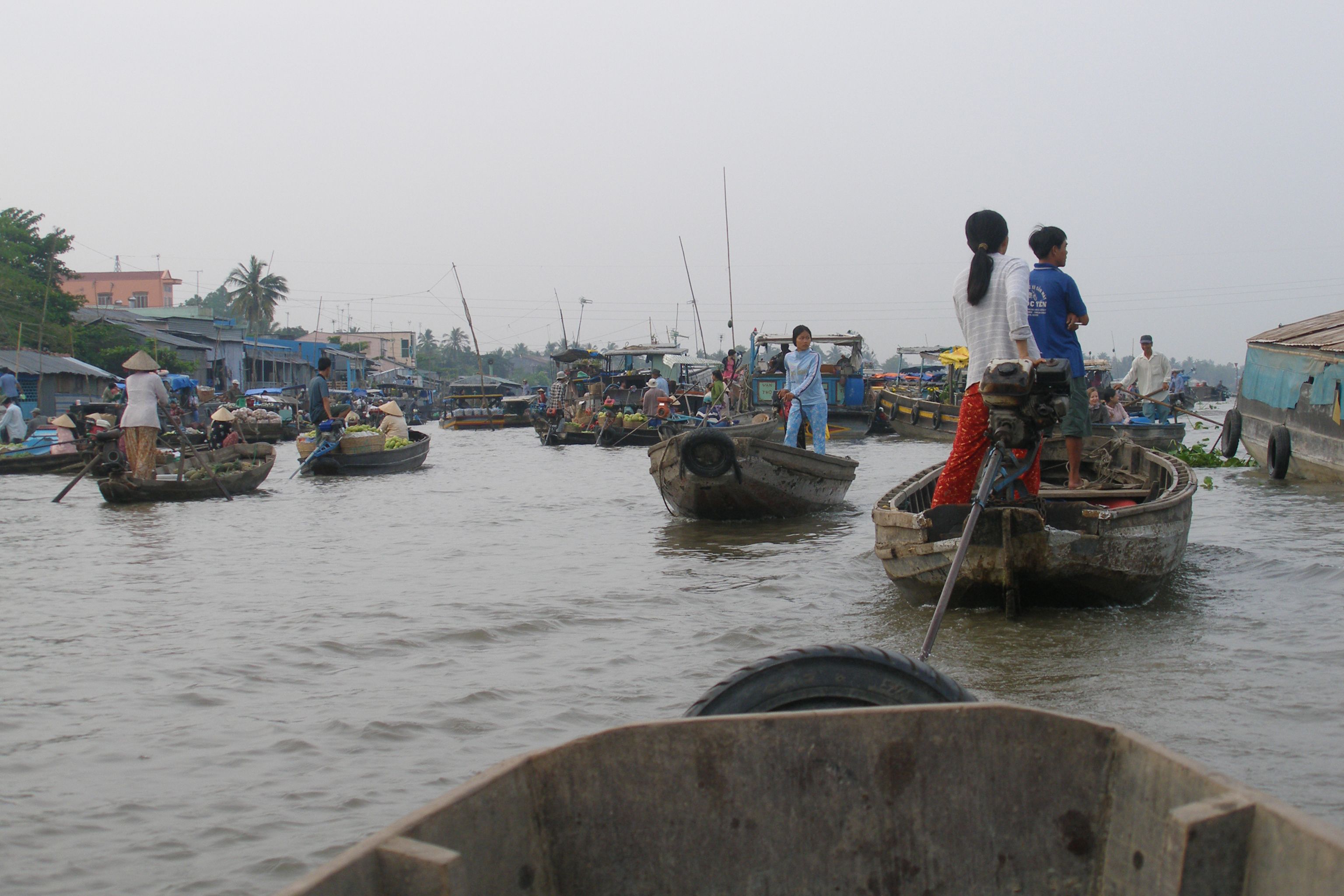
This is a working waterscape rather than a wilderness, and that is the appeal — life is arranged around the canals rather than around roads. Boats reach floating markets, fruit orchards, and villages where the front door faces the water. Get into the narrow channels by sampan, under nipa palm, and it is one of the most atmospheric river landscapes in Asia.
What to know before you go
🗓️ Best time
The dry season, roughly December to April, is the most comfortable and the easiest for boat travel. The floating season from about September to November brings high water, flooded fields and a very different look. Note the floating markets have shrunk considerably as roads and bridges have been built.
🧭 Getting there & access
Can Tho, the delta's main city, is about 3.5 to 4 hours by road from Ho Chi Minh City, or a short domestic flight. Boat trips leave from Can Tho, Cai Be, Ben Tre and Chau Doc. The Cai Rang floating market near Can Tho operates from very early morning.
Good to know
- Reach Cai Rang market before about 7am — it thins out quickly after sunrise.
- Swap the big tour boat for a sampan for the narrow canals; that is where the delta is.
- Stay overnight rather than doing a day trip from Ho Chi Minh City — the round trip eats the day.
- Homestays in Ben Tre and Vinh Long give far better access to the working canals.
Plan your visit
Easy🧭 Getting there
From Ho Chi Minh City (SGN), Vietnam
- Fly into Ho Chi Minh City
- Travel 3.5–4 hours by road to Can Tho, or fly domestically
- Take a dawn boat to the Cai Rang floating market
- Transfer to a sampan for the narrow canals and orchards
- Total travel
- Half a day from Ho Chi Minh City
- Time at site
- Two to three days, with at least one night in the delta itself
- Access
- No permits. Boat trips are booked locally or through homestays. Roads are good to the main towns; the canals are the real transport network.
🎒 What to bring & consider
- A hat and strong sun protection — the delta is flat, open and reflective
- Insect repellent, particularly for canal-side homestays at dusk
- Cash in dong for boats, markets and homestays
- An early alarm, since the markets are a dawn activity
- Realistic expectations about the floating markets, which are much reduced
👁️ What to expect
- Crowds
- Cai Rang draws a tour-boat crowd at sunrise. The smaller canals and the Ben Tre side stay quiet.
- Conditions
- Hot, humid and flat year-round. Boat travel is the norm and the canals are busy working waterways.
- Facilities
- Full range in Can Tho; homestays and small guesthouses throughout the smaller towns.
- The view
- Loaded produce boats at Cai Rang in first light, or a sampan under overhanging nipa palm in a narrow channel.
Times and requirements are approximate and change with season, weather, and local rules — confirm permits, fares, and schedules with operators before you travel.
Natural riches of the area
- Roughly 40,000 km² of river-built alluvial farmland
- The Mekong's distributary arms and a dense canal network
- Sediment delivery that both builds land and fertilises it
- Mangrove and melaleuca wetland at the coastal fringe
- Fisheries and rice paddy supporting a very large share of Vietnam's output
Local food
- Cá lóc nướng trui
- Snakehead fish grilled whole over straw and eaten with rice paper and herbs.
- Bún cá
- Fish noodle soup, made across the delta with local freshwater catch.
- Hủ tiếu
- A southern noodle soup, often eaten from boats at the floating markets.
- Delta fruit
- Rambutan, longan, durian and pomelo from the orchards along the canals.
Everything in the Mekong Delta was delivered by the river. Sediment carried down from the Tibetan Plateau has been dropped here for millions of years, building roughly 40,000 square kilometres of flat, exceptionally fertile ground that sits barely above sea level and produces a very large share of Vietnam’s rice. Vietnamese calls the river Cửu Long — nine dragons — for the number of arms it once used to reach the sea. Two of those have silted up since, and the name has simply outlasted the geography.
Sediment is also the delta’s problem. Dams far upstream now trap much of it before it ever arrives, so the land is no longer being rebuilt at the rate the sea erodes it. At the same time, heavy groundwater extraction is causing the delta to subside — in places faster than sea level is rising — and salt water pushes further inland each dry season, changing what can be grown where. None of this is visible from a boat on a bright morning, when the canals are full of produce and the orchards are heavy. But it is the reason the delta is one of the most closely watched landscapes in Asia, and why a place built entirely by a river is now shaped mostly by decisions taken two thousand kilometres upstream.
Mekong Delta: common questions
How do you get to Mekong Delta?
From Ho Chi Minh City (SGN), Vietnam: Fly into Ho Chi Minh City; Travel 3.5–4 hours by road to Can Tho, or fly domestically; Take a dawn boat to the Cai Rang floating market; Transfer to a sampan for the narrow canals and orchards. Total travel time: Half a day from Ho Chi Minh City.
When is the best time to visit Mekong Delta?
The dry season, roughly December to April, is the most comfortable and the easiest for boat travel. The floating season from about September to November brings high water, flooded fields and a very different look. Note the floating markets have shrunk considerably as roads and bridges have been built.
How long should you spend at Mekong Delta?
Two to three days, with at least one night in the delta itself. Total travel time: Half a day from Ho Chi Minh City.
What should you bring to Mekong Delta?
A hat and strong sun protection — the delta is flat, open and reflective Insect repellent, particularly for canal-side homestays at dusk Cash in dong for boats, markets and homestays An early alarm, since the markets are a dawn activity Realistic expectations about the floating markets, which are much reduced
Do you need a permit or guide for Mekong Delta?
No permits. Boat trips are booked locally or through homestays. Roads are good to the main towns; the canals are the real transport network.
Is Mekong Delta crowded, and what are conditions like?
Cai Rang draws a tour-boat crowd at sunrise. The smaller canals and the Ben Tre side stay quiet. Hot, humid and flat year-round. Boat travel is the norm and the canals are busy working waterways. Facilities: Full range in Can Tho; homestays and small guesthouses throughout the smaller towns.
Added
More wonders to explore