Kaieteur Falls
📍 Kaieteur National Park, Potaro-Siparuni, central Guyana
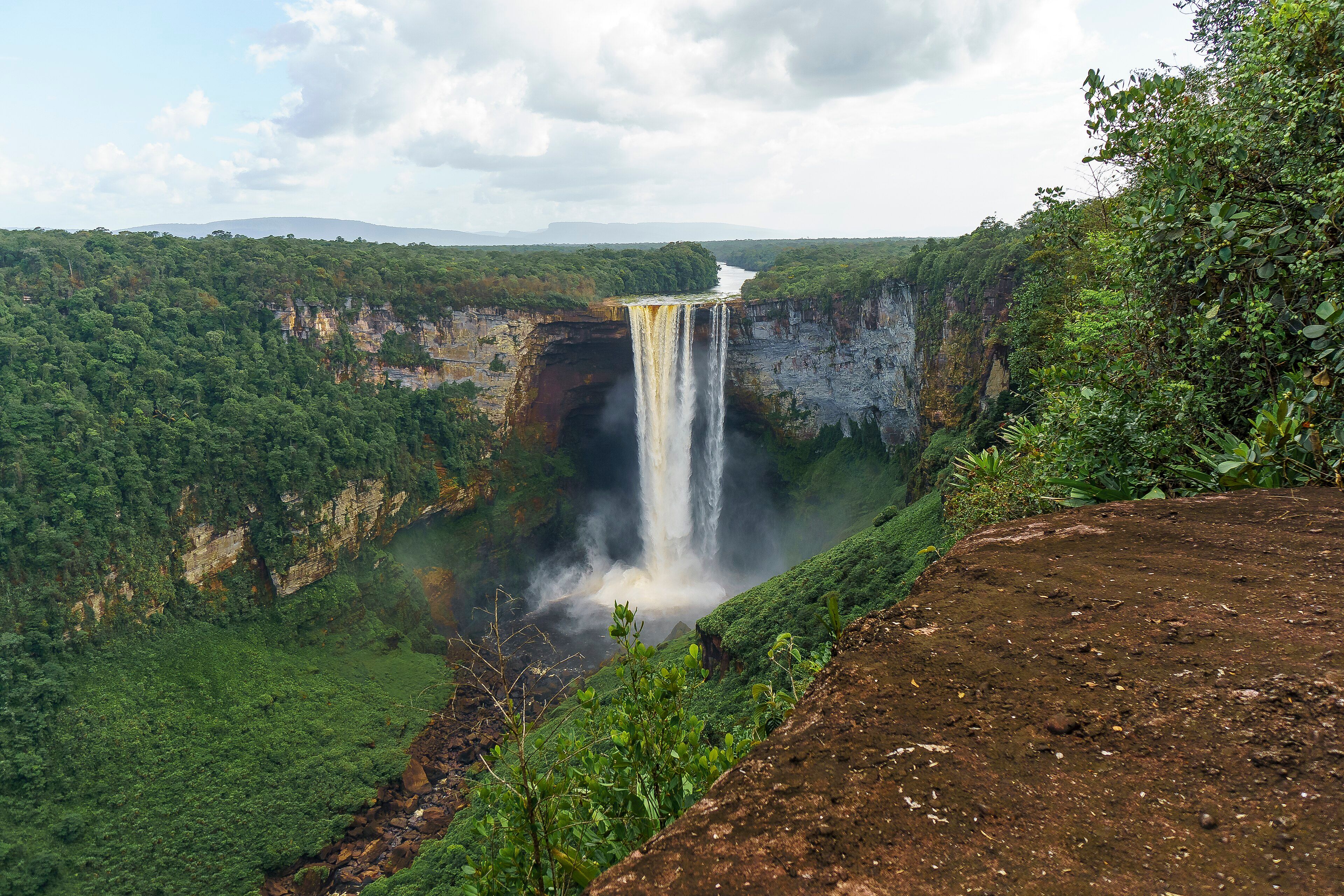
A single 226-metre drop of the Potaro River into rainforest gorge — roughly five times the height of Niagara, carrying enough water to make it one of the most powerful waterfalls on Earth, and with almost nothing built around it.
What makes it marvelous
Height and volume are usually mutually exclusive in waterfalls: the very tall ones sit on small headwater streams, because that is where the cliffs are, while the high-volume ones sit on big rivers that have already worn their gradients flat. Kaieteur is one of the rare falls that has both. The Potaro River goes over a sandstone and conglomerate lip and drops 226 metres in one clear fall to the first break — 251 metres if you include the cascades below it — carrying an average of 663 cubic metres a second. That is about four and a half times the height of Niagara and roughly twice that of Victoria Falls, on a river with real weight behind it. It sits in the middle of Guyana's rainforest with essentially nothing built around it: no barriers, no viewing platforms in the usual sense, and a handful of vantage points you walk to across bare rock. On the cliff-top, small frogs live out their entire lives in the water held by giant tank bromeliads growing in the spray.
Why visit
Very few waterfalls of this scale anywhere are still effectively undeveloped, and fewer let you stand at the lip. The scale takes a while to register — the plunge pool is far enough below that the water appears to fall slowly — and the setting is unbroken rainforest running to the escarpment of the Pakaraima Mountains on every horizon.
What to know before you go
🗓️ Best time
May to August and November to January bring the heaviest flow, when the falls are at their most powerful but flights are more often cancelled by weather. The drier months from February to April give more reliable flying and clearer views, with the river lower.
🧭 Getting there & access
Almost everyone arrives by light aircraft from Georgetown — Ogle or Cheddi Jagan — landing at the airstrip inside Kaieteur National Park, about a fifteen-minute walk from the top of the falls. Day trips are the norm. The overland route is a multi-day expedition by road, river and foot and needs to be arranged well in advance.
Good to know
- Book the flight with slack in your schedule; weather cancellations are common and there is no alternative for a fixed date.
- There are no railings at the viewpoints. The rock near the lip is wet and sloped — keep well back from it.
- Look for the tank bromeliads on the cliff-top plants, not just at the water.
- Take a light rain shell; the spray reaches a long way in high flow.
Plan your visit
Easy🧭 Getting there
From Georgetown (GEO), Guyana
- Fly into Georgetown
- Take a light-aircraft day flight from Ogle or Cheddi Jagan
- Land at the airstrip inside Kaieteur National Park
- Walk about fifteen minutes to the viewpoints above the falls
- Total travel
- About an hour each way by air from Georgetown
- Time at site
- 2–3 hours on a standard day flight
- Access
- The park charges entry, usually bundled into the flight package. Aircraft are small and weight-limited, so baggage allowances are strict. Flights are weather-dependent and cancel at short notice; build in spare days rather than planning around a single slot.
🎒 What to bring & consider
- Flexible dates, because the flight is the whole trip
- Shoes with grip for wet, sloping rock
- A light rain shell and a bag that will keep a camera dry
- Insect repellent for the trail between the strip and the falls
- Cash in Guyanese dollars; there is nothing to buy at the falls
👁️ What to expect
- Crowds
- Light. Aircraft capacity limits numbers, and there are usually only a handful of small groups at a time.
- Conditions
- Hot and humid, with heavy spray near the lip. Short, flat walking on rock and forest trail.
- Facilities
- A guest house and rangers' quarters near the airstrip. No shops, no barriers, no infrastructure at the falls themselves.
- The view
- The full drop from the Johnson's View side in morning light, with the gorge and the rainforest running away behind it.
Times and requirements are approximate and change with season, weather, and local rules — confirm permits, fares, and schedules with operators before you travel.
Natural riches of the area
- A single uninterrupted drop of 226 m; 251 m including the cascades below
- Average discharge of 663 m³/s — among the most powerful falls in the world
- A sandstone and conglomerate cliff at the edge of the Potaro Plateau
- Giant tank bromeliads on the cliff-top holding entire amphibian life cycles
- Unbroken rainforest running out to the Pakaraima escarpment
Local food
- Pepperpot
- Meat slow-cooked in cassareep, made from bitter cassava — Guyana's national dish.
- Cook-up rice
- Rice cooked down with peas, coconut milk and whatever meat is to hand.
- Metemgee
- Ground provisions and dumplings simmered in coconut milk.
- Cassava bread
- Flat bread pressed from cassava, an Indigenous staple of the interior.
Waterfall records tend to split into two camps. The tallest falls are threads of water coming off high cliffs, because that is where the cliffs are, and by the time a river is big enough to be impressive it has usually worn its bed down to something gentle. Kaieteur is one of the few places where the two coincide.
The Potaro River goes over a sandstone and conglomerate lip in the middle of Guyana’s rainforest and drops 226 metres in a single clear fall — 251 if you count the cascades below the plunge pool — with an average of 663 cubic metres of water a second going over. That is around four and a half times the height of Niagara and about twice Victoria Falls, on a river carrying serious volume. It is why Kaieteur is regularly listed among the most powerful single-drop waterfalls anywhere.
What surprises most visitors is how little is there. The park was set aside in 1929, which makes it one of the oldest protected areas in South America, and it has stayed close to undeveloped since. There is an airstrip a fifteen-minute walk from the top, a ranger station, and a set of viewpoints on bare rock with no barriers at all. You walk to the edge and there is nothing between you and the drop. This is worth taking seriously; the rock slopes toward the lip and is permanently wet.
The detail people remember afterwards is much smaller than the falls. Giant tank bromeliads grow on the cliff-top in the permanent spray, each holding a pool of water in the cup of its leaves, and small frogs spend their entire lives in them — eggs, tadpoles and adults, in a plant. It is a reminder of how much a waterfall is doing besides falling.
Kaieteur Falls: common questions
How do you get to Kaieteur Falls?
From Georgetown (GEO), Guyana: Fly into Georgetown; Take a light-aircraft day flight from Ogle or Cheddi Jagan; Land at the airstrip inside Kaieteur National Park; Walk about fifteen minutes to the viewpoints above the falls. Total travel time: About an hour each way by air from Georgetown.
When is the best time to visit Kaieteur Falls?
May to August and November to January bring the heaviest flow, when the falls are at their most powerful but flights are more often cancelled by weather. The drier months from February to April give more reliable flying and clearer views, with the river lower.
How long should you spend at Kaieteur Falls?
2–3 hours on a standard day flight. Total travel time: About an hour each way by air from Georgetown.
What should you bring to Kaieteur Falls?
Flexible dates, because the flight is the whole trip Shoes with grip for wet, sloping rock A light rain shell and a bag that will keep a camera dry Insect repellent for the trail between the strip and the falls Cash in Guyanese dollars; there is nothing to buy at the falls
Do you need a permit or guide for Kaieteur Falls?
The park charges entry, usually bundled into the flight package. Aircraft are small and weight-limited, so baggage allowances are strict. Flights are weather-dependent and cancel at short notice; build in spare days rather than planning around a single slot.
Is Kaieteur Falls crowded, and what are conditions like?
Light. Aircraft capacity limits numbers, and there are usually only a handful of small groups at a time. Hot and humid, with heavy spray near the lip. Short, flat walking on rock and forest trail. Facilities: A guest house and rangers' quarters near the airstrip. No shops, no barriers, no infrastructure at the falls themselves.
Added
More wonders to explore