Iguazú Falls
📍 Paraná, Brazil / Misiones, Argentina border
A thundering wall of water on the Brazil–Argentina border — hundreds of individual falls spread across nearly three kilometres of jungle, culminating in the vast horseshoe chasm of the Devil's Throat.
What makes it marvelous
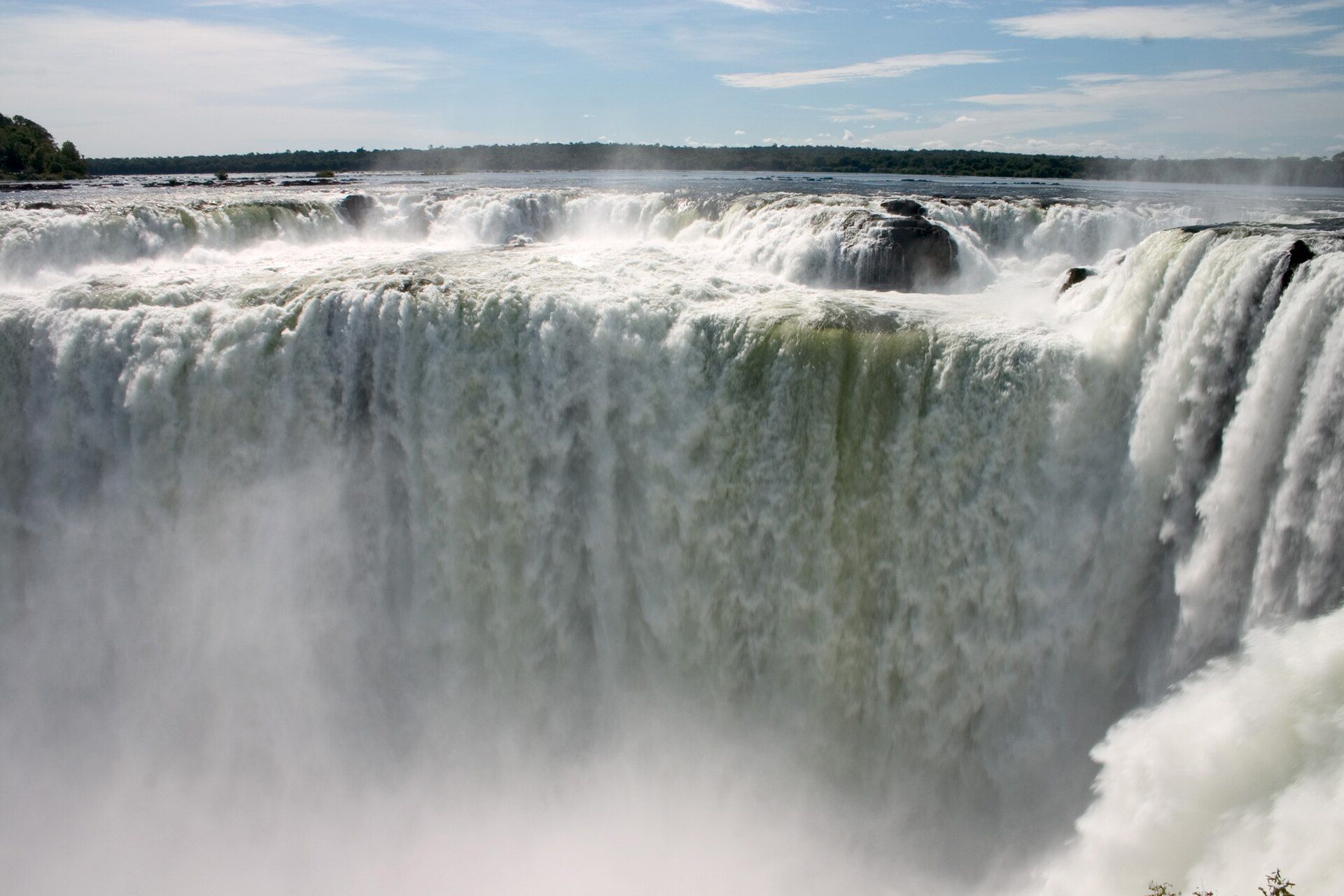
Iguazú is not one waterfall but a system of some 275 cascades strung along a 2.7-kilometre curtain, where the Iguazú River plunges up to about 80 metres off a basalt escarpment into a gorge below. Its centrepiece, the Devil's Throat (Garganta del Diablo), is a U-shaped abyss into which a huge share of the river collapses in permanent thunder and spray. Surrounded by protected subtropical rainforest teeming with toucans, coatis, and jaguars, it dwarfs Niagara in breadth and is shared by two UNESCO-listed national parks.
Why visit
The scale and setting are overwhelming: walkways lead you out over and alongside the falls, rainbows arc through the spray, and swifts dart behind the curtains of water. The Argentine side offers close, immersive catwalks; the Brazilian side gives the grand panorama.
Still deciding?
Iguazú Falls comes up most often against these — each one weighs cost, effort, season and crowds side by side.
More views of Iguazú Falls
Additional photographs of the actual site — each freely licensed, with its photographer and licence credited.
What to know before you go
🗓️ Best time
The falls run year-round; drier winter months (roughly May–September) mean easier trails and clearer skies, while the rainy season brings maximum flow (and sometimes closures of the Devil's Throat walkway).
🧭 Getting there & access
From Foz do Iguaçu (Brazil) or Puerto Iguazú (Argentina), each with its own national park and airport. The two sides are a short border crossing apart; many visitors see both.
Good to know
- Do both sides if you can — Argentina for the close catwalks, Brazil for the panorama.
- Expect to get wet near the Devil's Throat; protect cameras and phones.
- Keep food hidden from the bold coatis, and don't feed the wildlife.
Plan your visit
Easy🧭 Getting there
From Foz do Iguacu (IGU), Brazil or Puerto Iguazu (IGR), Argentina
- Fly from Sao Paulo or Buenos Aires — roughly 1h45–2h
- Airport to park entrance — about 20–30 minutes
- Shuttle buses and a park train move you between trailheads inside
- Total travel
- Half a day from either capital
- Time at site
- A full day on each side; two days in total
- Access
- Separate national park entry in each country, and moving between them is an international border crossing — check visa and reciprocity requirements for your nationality. The Argentine side's Garganta del Diablo walkway has been closed for months at a time after flood damage; confirm it is open before building a day around it.
🎒 What to bring & consider
- Rain gear and a waterproof phone case — several walkways go straight through the spray
- Shoes with grip; the metal walkways are slick when wet
- Insect repellent for the subtropical forest
- The sense not to feed the coatis — they bite, and they will go through an open bag
- Travel-clinic advice on yellow fever vaccination for the region
👁️ What to expect
- Crowds
- Heavy on both sides through the middle of the day, and worse during Brazilian and Argentine school holidays. The first hour after opening is far calmer.
- Conditions
- Extensive flat metal walkways — easy underfoot but long distances, in heat and humidity.
- Facilities
- Good on both sides: visitor centres, food, toilets, shops.
- The view
- The Brazilian side gives you the panorama; the Argentine side puts you directly above the water. Flow peaks in the wet months, roughly December to March, when floods occasionally close walkways outright.
Times and requirements are approximate and change with season, weather, and local rules — confirm permits, fares, and schedules with operators before you travel.
Natural riches of the area
- The Iguazú River and a vast basalt escarpment
- Protected Atlantic/subtropical rainforest
- Jaguars, toucans, coatis, and rich biodiversity
- Immense freshwater flow (and downstream hydropower nearby)
Local food
- Churrasco
- South American grilled meats, a staple on both sides of the border.
- Chipá
- Warm cheese-and-cassava bread popular in the border region.
- Mate & tropical fruit
- The shared yerba mate infusion and abundant local fruit.
Iguazú overwhelms by breadth. Where Niagara is a single mighty curtain, Iguazú is a whole army of them — some 275 separate cascades strung along nearly three kilometres of the Brazil–Argentina border, the Iguazú River tipping off a basalt escarpment into a jungle gorge. At its heart is the Devil’s Throat, a horseshoe abyss where an enormous share of the river collapses at once in a permanent roar and a column of spray visible from far away.
What makes it more than a wall of water is the setting: protected subtropical rainforest alive with toucans, coatis, and, unseen, jaguars, with rainbows hanging in the mist and swifts nesting behind the falls. Walkways carry you right out among the cataracts on the Argentine side and to a grand panorama on the Brazilian one. It is, by common consent, one of the greatest waterfalls on the planet — and a rare wonder generous enough to be shared by two countries.
Roughly four-fifths of the falls sit on the Argentine side, which is why its network of catwalks and the little Rainforest Ecological Train get you right out among and above the water; the Brazilian side, with far fewer individual falls, holds the grandstand panorama of the whole curtain. Speedboats run right up under the cascades from both countries for anyone happy to be soaked to the skin. The Devil’s Throat itself straddles the international border, so standing at its lip you are looking from one country into another across the roar.
Iguazú Falls: common questions
How do you get to Iguazú Falls?
From Foz do Iguacu (IGU), Brazil or Puerto Iguazu (IGR), Argentina: Fly from Sao Paulo or Buenos Aires — roughly 1h45–2h; Airport to park entrance — about 20–30 minutes; Shuttle buses and a park train move you between trailheads inside. Total travel time: Half a day from either capital.
When is the best time to visit Iguazú Falls?
The falls run year-round; drier winter months (roughly May–September) mean easier trails and clearer skies, while the rainy season brings maximum flow (and sometimes closures of the Devil's Throat walkway).
How long should you spend at Iguazú Falls?
A full day on each side; two days in total. Total travel time: Half a day from either capital.
What should you bring to Iguazú Falls?
Rain gear and a waterproof phone case — several walkways go straight through the spray Shoes with grip; the metal walkways are slick when wet Insect repellent for the subtropical forest The sense not to feed the coatis — they bite, and they will go through an open bag Travel-clinic advice on yellow fever vaccination for the region
Do you need a permit or guide for Iguazú Falls?
Separate national park entry in each country, and moving between them is an international border crossing — check visa and reciprocity requirements for your nationality. The Argentine side's Garganta del Diablo walkway has been closed for months at a time after flood damage; confirm it is open before building a day around it.
Is Iguazú Falls crowded, and what are conditions like?
Heavy on both sides through the middle of the day, and worse during Brazilian and Argentine school holidays. The first hour after opening is far calmer. Extensive flat metal walkways — easy underfoot but long distances, in heat and humidity. Facilities: Good on both sides: visitor centres, food, toilets, shops.
Added Updated
More wonders to explore