The Fann Mountains
📍 Sughd Province, western Tajikistan
About a hundred peaks in a compact block of the western Pamir-Alay, a dozen of them above 5,000 metres, with turquoise lakes dammed by landslides sitting under the walls.
What makes it marvelous
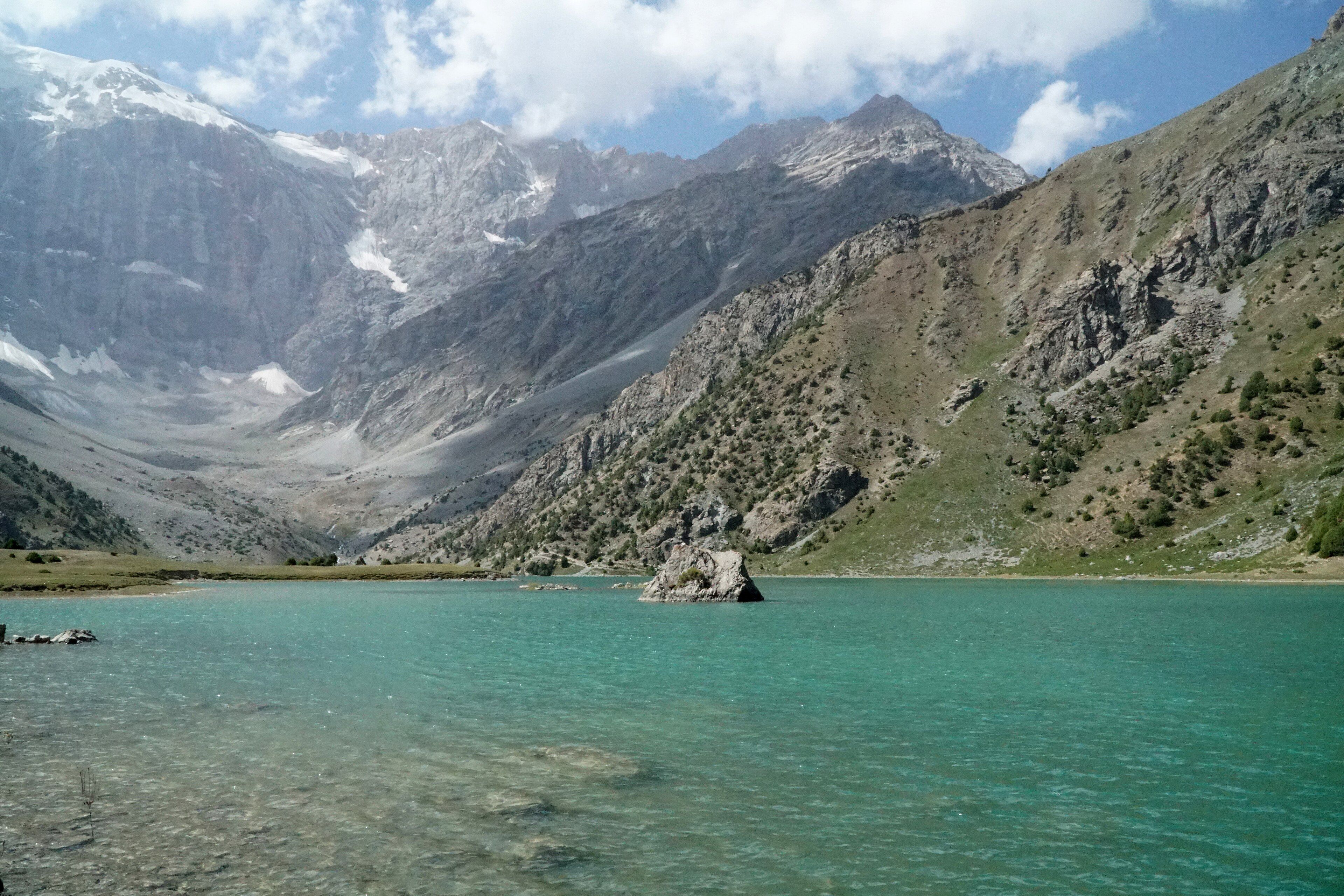
The Fanns are the western end of the Pamir-Alay system, wedged between the Zarafshan Range to the north and the Gissar Range to the south, and they are unusually concentrated: roughly a hundred peaks packed into a small area, with relative reliefs of up to 1,500 metres and at least eight summits over 5,000. Chimtarga is the highest at 5,489 metres, with Bodkhona at 5,138, Mirali at 5,132, Energia at 5,120, Zamok at 5,070, Chapdara at 5,050 and Little Hansa at 5,031. Underneath them sit the lakes that make the range famous — Kulikalon beneath Chimtarga's northern slope, the Alaudin group in the Chapdara valley, Big Allo, and Iskanderkul, which lies at 2,195 metres, covers 3.4 square kilometres and reaches 72 metres deep. Iskanderkul exists because a landslide blocked the Saratogh river; the water it holds back drains out as the Iskander Darya. The colour is the thing people remember: mineral turquoise against grey limestone and snow.
Why visit
It is high-mountain trekking without the permit apparatus or the altitude of the Pamirs proper — a week-long circuit can take in several 5,000-metre walls and half a dozen lakes, camping beside them. The Fanns are also unusually accessible for their scale, reachable from Panjakent in a morning, with Samarkand a short drive away over the border.
What to know before you go
🗓️ Best time
Late June to mid-September is the trekking season, when the passes are clear of snow and the lake camps are usable. July and August are the mountaineering window. Outside that the high ground is snowbound and the passes close.
🧭 Getting there & access
Panjakent is the gateway, reached from Dushanbe or — often more easily — from Samarkand in Uzbekistan, a short distance over the border. From Panjakent, roads run into the Seven Lakes valley and toward the Alaudin and Kulikalon trailheads. Iskanderkul is separately reached, about 134 km from Dushanbe and 23 km off the Dushanbe–Khujand road.
Good to know
- Hire a local guide and pack animals in Panjakent; the trail network is not signed and maps are approximate.
- Acclimatise before crossing the high passes — several exceed 4,000 metres.
- Carry all food in. There is nothing to buy once you leave the valley villages.
- Check current border-crossing rules if you are coming from Samarkand; they change.
Plan your visit
Strenuous🧭 Getting there
From Dushanbe (DYU) or Samarkand, then Panjakent
- Fly to Dushanbe, or to Samarkand and cross to Panjakent
- Travel to Panjakent and arrange a guide and pack animals
- Trek in to the Kulikalon or Alaudin lake basins
- Cross the high passes on a multi-day circuit, or visit Iskanderkul separately by road
- Total travel
- A day from Dushanbe to a trailhead
- Time at site
- 5–8 days for a circuit; a long day trip for Iskanderkul
- Access
- No special permit is needed for the Fanns themselves, unlike the Pamir corridor further east. Guides, porters and pack animals are arranged in Panjakent or at the trailhead villages. Roads to the trailheads are rough and often need a four-wheel-drive; river crossings can close them after rain.
🎒 What to bring & consider
- Full mountain camping kit — there are no huts on the circuits
- Water treatment; the streams carry glacial silt
- Warm layers for lake camps above 3,000 m, which freeze even in August
- Cash in somoni, since there is no banking beyond Panjakent
- Time to acclimatise before the passes
👁️ What to expect
- Crowds
- Very light. This is one of the least-visited high ranges in Central Asia.
- Conditions
- Hot and dry in the valleys, cold at altitude. Steep scree, moraine and long pass days.
- Facilities
- Homestays and small guesthouses in the valley villages; a base camp at Alaudin. Nothing on the passes.
- The view
- Kulikalon in early morning, the turquoise water still and the Chimtarga wall behind it with snow in the couloirs.
Times and requirements are approximate and change with season, weather, and local rules — confirm permits, fares, and schedules with operators before you travel.
Natural riches of the area
- Around a hundred peaks, at least eight above 5,000 m; Chimtarga 5,489 m
- Kulikalon, Alaudin and Big Allo lakes beneath the high walls
- Iskanderkul — 3.4 km², 72 m deep, dammed by a landslide across the Saratogh
- The Haftkul or Seven Lakes chain above Panjakent
- Juniper forest, sub-alpine meadow and an Important Bird Area around Iskanderkul
Local food
- Osh
- The Central Asian rice pilaf with mutton, carrot and cumin, cooked in a kazan.
- Qurutob
- Flatbread torn into a dish of dried yoghurt, onion and herbs — Tajikistan's national dish.
- Non
- Round tandoor bread, stamped and baked to the wall of the oven.
- Chakka
- Strained sour yoghurt eaten with bread and herbs at almost every meal.
Tajikistan is mostly mountain, and most of the attention goes east to the Pamirs. The Fanns are the other option: a compact block at the western end of the Pamir-Alay, between the Zarafshan and Gissar ranges, holding around a hundred peaks in an area you can walk across in a week.
They are concentrated rather than vast. At least eight summits pass 5,000 metres — Chimtarga highest at 5,489, then Bodkhona, Mirali, Energia, Zamok, Chapdara, Little Hansa — and the walls beneath them rise as much as 1,500 metres from the valley floors. That density is why a single trekking circuit here can put you under more big faces than a much longer route in a bigger range.
What people photograph, though, is the water. The Fanns are full of lakes, and they are an improbable mineral turquoise against grey limestone. Kulikalon sits below Chimtarga’s northern slope; the Alaudin group fills the Chapdara valley; the Haftkul, the Seven Lakes, run up a valley above Panjakent. The largest, Iskanderkul, is a lake only because a landslide fell across the Saratogh river and stopped it — 3.4 square kilometres of water at 2,195 metres, 72 metres deep, draining out the far side as the Iskander Darya.
Access is the pleasant surprise. The Fanns need no special permit, unlike the Pamir corridor further east, and Panjakent — the gateway — is closer to Samarkand than to Dushanbe. Guides and pack animals are hired in the valley villages, the trails are unsigned, and once you are past them there is nothing at all until you come down the other side.
The Fann Mountains: common questions
How do you get to The Fann Mountains?
From Dushanbe (DYU) or Samarkand, then Panjakent: Fly to Dushanbe, or to Samarkand and cross to Panjakent; Travel to Panjakent and arrange a guide and pack animals; Trek in to the Kulikalon or Alaudin lake basins; Cross the high passes on a multi-day circuit, or visit Iskanderkul separately by road. Total travel time: A day from Dushanbe to a trailhead.
When is the best time to visit The Fann Mountains?
Late June to mid-September is the trekking season, when the passes are clear of snow and the lake camps are usable. July and August are the mountaineering window. Outside that the high ground is snowbound and the passes close.
How long should you spend at The Fann Mountains?
5–8 days for a circuit; a long day trip for Iskanderkul. Total travel time: A day from Dushanbe to a trailhead.
What should you bring to The Fann Mountains?
Full mountain camping kit — there are no huts on the circuits Water treatment; the streams carry glacial silt Warm layers for lake camps above 3,000 m, which freeze even in August Cash in somoni, since there is no banking beyond Panjakent Time to acclimatise before the passes
Do you need a permit or guide for The Fann Mountains?
No special permit is needed for the Fanns themselves, unlike the Pamir corridor further east. Guides, porters and pack animals are arranged in Panjakent or at the trailhead villages. Roads to the trailheads are rough and often need a four-wheel-drive; river crossings can close them after rain.
Is The Fann Mountains crowded, and what are conditions like?
Very light. This is one of the least-visited high ranges in Central Asia. Hot and dry in the valleys, cold at altitude. Steep scree, moraine and long pass days. Facilities: Homestays and small guesthouses in the valley villages; a base camp at Alaudin. Nothing on the passes.
Added
More wonders to explore