Biri Rock Formations
📍 Biri Island, Northern Samar, Eastern Visayas
Massive sandstone rock formations on a remote island where the Pacific Ocean meets the ferocious San Bernardino Strait — sculpted over millennia into cliffs, arches, and tidal pools battered by giant waves.
What makes it marvelous
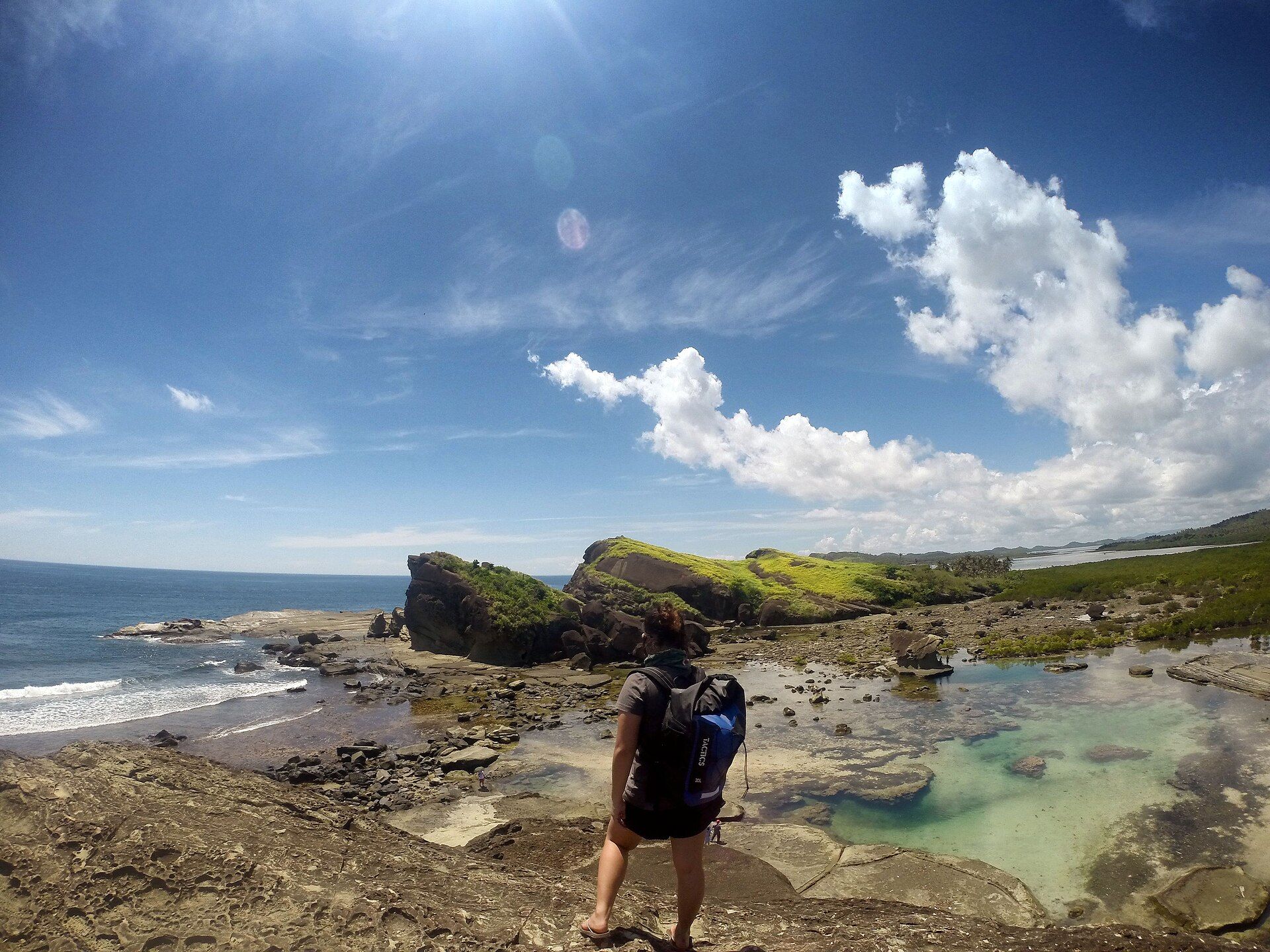
Biri sits at the meeting point of the open Pacific and the San Bernardino Strait, one of the roughest tidal channels in the Philippines. The relentless collision of ocean swell and racing tidal currents has carved the island's sandstone into seven great formations — Magasang, Macadlaw, Puhunan, and others — a landscape of layered cliffs, sea arches, and natural tidal pools where you can bathe as waves explode against the rocks just metres away.
Why visit
It's raw, elemental scenery well off the tourist trail: climbing the wind-scoured rock terraces at low tide, soaking in natural pools while the Pacific hammers the seaward cliffs, and watching the strait's powerful currents. Sunrise and sunset over the formations are spectacular.
What to know before you go
🗓️ Best time
The drier, calmer months (roughly March–June); the seas here can be very rough, and the formations are best explored at low tide.
🧭 Getting there & access
From Catarman or Allen in Northern Samar to Lavezares, then a boat crossing to Biri Island. Local guides run trips to the formations; go at low tide.
Good to know
- Explore at low tide and heed guides about currents — the strait is dangerous.
- Wear sturdy footwear for the sharp, uneven rock.
- Time sunrise or sunset for the best light on the formations.
Plan your visit
Moderate🧭 Getting there
From Catarman (CRM), Northern Samar
- Fly Manila → Catarman — roughly 1h15
- Van Catarman → Lavezares port — about 1h30
- Boat Lavezares → Biri Island — roughly 45 minutes to an hour
- Habal-habal from Biri town → the formations — 15–20 minutes
- Total travel
- Most of a day from Manila
- Time at site
- An overnight, so you can hit the right tide
- Access
- Open access with a small local fee and a guide arranged in Biri town. The genuine gate is the tide: the natural pools on Magasang and Magsapad only exist at low water, and at high tide the formations are simply cliffs being hit by the sea. Get the day's tide times locally before you plan the walk. The Biri crossing sits at the mouth of the San Bernardino Strait, one of the roughest stretches of water in the country, and boats are cancelled outright when it is up.
🎒 What to bring & consider
- The tide table for your date — arriving at high water means you have travelled a full day to look at the outside of the rocks
- Grippy shoes you can soak, because the approach crosses sharp, algae-slick rock rather than sand
- Sun protection for entirely exposed sandstone with no shade at any point
- Motion sickness treatment for the strait crossing, which is short and often violent
- Cash — Biri is small and there is no ATM
👁️ What to expect
- Crowds
- Very few foreign visitors. Busier with domestic groups on long weekends.
- Conditions
- Hot, exposed scrambling over layered sandstone, with strong surf on the seaward side. The swim in the pools is calm; the water beyond them is not.
- Facilities
- Basic homestays and small eateries in Biri town. Nothing at the formations.
- The view
- Sunset from the top of Magasang with the layered rock shelves catching the last light and the pools below at low tide. That combination — low tide and clear sky at dusk — is what an overnight buys you.
Times and requirements are approximate and change with season, weather, and local rules — confirm permits, fares, and schedules with operators before you travel.
Natural riches of the area
- Layered sandstone sculpted by ocean and tidal forces
- Powerful tidal currents of the San Bernardino Strait
- Tidal pools and rich intertidal marine life
- Seaweed farming and coastal fisheries
Local food
- Fresh seafood
- Fish, crab, and shellfish from the surrounding productive waters.
- Seaweed (guso) salad
- Locally farmed seaweed dressed with vinegar — a Samar staple.
- Native rice cakes
- Coconut-and-rice kakanin from the island's kitchens.
Biri is where the Philippines takes the full force of the Pacific. The little island sits at the mouth of the San Bernardino Strait, one of the country’s roughest tidal channels, and the endless battle between ocean swell and racing currents has sculpted its sandstone into seven monumental formations — layered cliffs, arches, and wave-scoured terraces named Magasang, Macadlaw, Puhunan, and more.
At low tide you can climb across the rock and settle into natural tidal pools while, just beyond, the open Pacific detonates against the seaward cliffs in sheets of spray. It’s elemental, uncrowded, and genuinely thrilling — a landscape that exists purely because of where it stands, in the path of the sea. Come at low tide, respect the currents, and stay for the light at either end of the day.
Biri Rock Formations: common questions
How do you get to Biri Rock Formations?
From Catarman (CRM), Northern Samar: Fly Manila → Catarman — roughly 1h15; Van Catarman → Lavezares port — about 1h30; Boat Lavezares → Biri Island — roughly 45 minutes to an hour; Habal-habal from Biri town → the formations — 15–20 minutes. Total travel time: Most of a day from Manila.
When is the best time to visit Biri Rock Formations?
The drier, calmer months (roughly March–June); the seas here can be very rough, and the formations are best explored at low tide.
How long should you spend at Biri Rock Formations?
An overnight, so you can hit the right tide. Total travel time: Most of a day from Manila.
What should you bring to Biri Rock Formations?
The tide table for your date — arriving at high water means you have travelled a full day to look at the outside of the rocks Grippy shoes you can soak, because the approach crosses sharp, algae-slick rock rather than sand Sun protection for entirely exposed sandstone with no shade at any point Motion sickness treatment for the strait crossing, which is short and often violent Cash — Biri is small and there is no ATM
Do you need a permit or guide for Biri Rock Formations?
Open access with a small local fee and a guide arranged in Biri town. The genuine gate is the tide: the natural pools on Magasang and Magsapad only exist at low water, and at high tide the formations are simply cliffs being hit by the sea. Get the day's tide times locally before you plan the walk. The Biri crossing sits at the mouth of the San Bernardino Strait, one of the roughest stretches of water in the country, and boats are cancelled outright when it is up.
Is Biri Rock Formations crowded, and what are conditions like?
Very few foreign visitors. Busier with domestic groups on long weekends. Hot, exposed scrambling over layered sandstone, with strong surf on the seaward side. The swim in the pools is calm; the water beyond them is not. Facilities: Basic homestays and small eateries in Biri town. Nothing at the formations.
Added Updated
More wonders to explore