Mount Kenya
📍 Central Kenya
Africa's second-highest peak — the eroded core of an ancient volcano, crowned with glaciers on the equator and ringed by bizarre giant plants found nowhere else.
What makes it marvelous
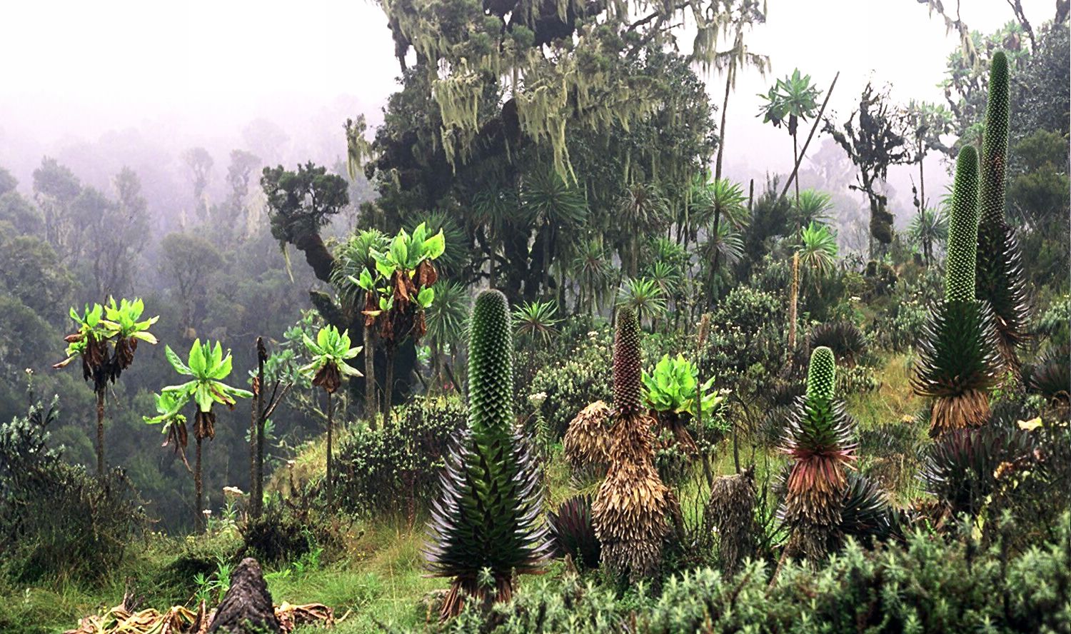
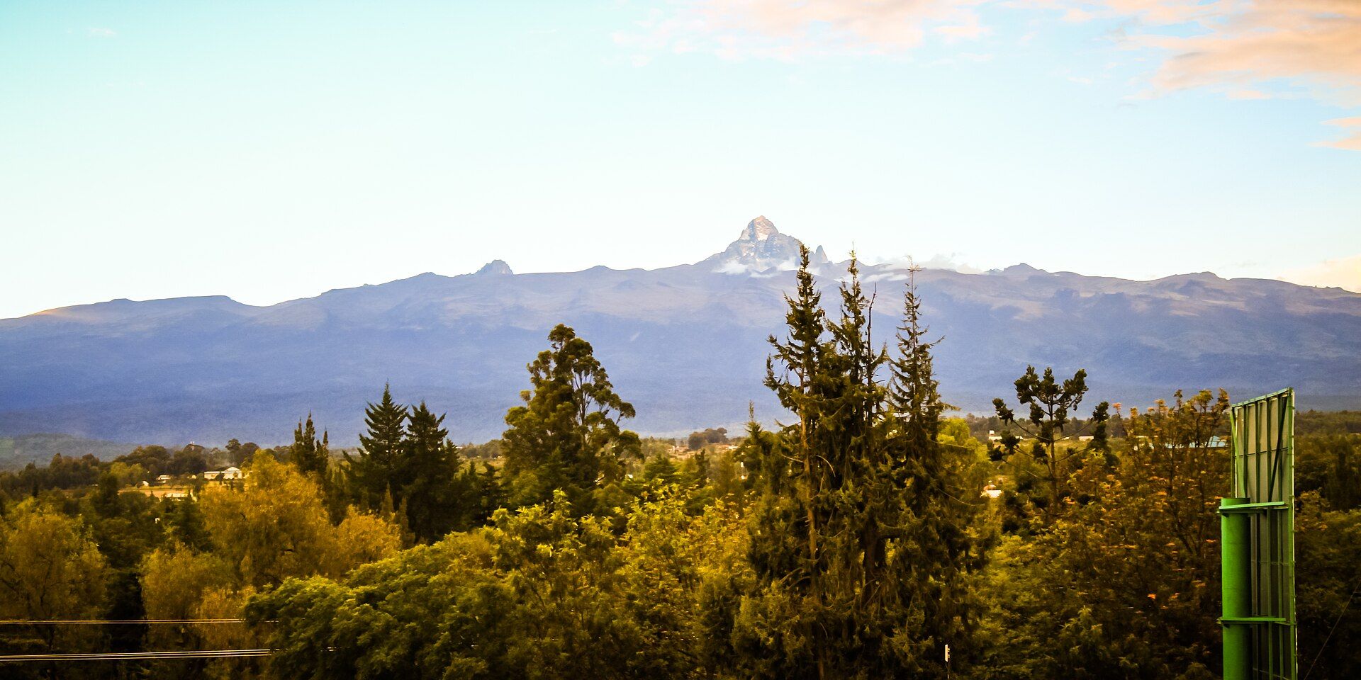
Mount Kenya rises to 5,199 metres, the second-highest mountain in Africa, and it is the deeply eroded remnant of a once far larger volcano — what remains today are the hard volcanic plugs that filled its throat, weathered into jagged rock spires, chief among them Batian and Nelion. Extraordinarily, it carries glaciers almost exactly on the equator, though they are retreating fast. Climbing its flanks means passing through a series of dramatically different worlds: farmland, then dense montane forest and bamboo, then a surreal afro-alpine zone where giant lobelias and groundsels grow into weird tree-sized forms found only on East Africa's high mountains, and finally rock, ice, and thin air. The mountain holds deep cultural importance for the Kikuyu people who farm its lower slopes, and it is a UNESCO World Heritage Site.
Why visit
Trekking Mount Kenya takes you from equatorial forest to glaciers in a few days, through a bizarre alpine garden of giant plants — a quieter, wilder, and more varied climb than its famous neighbour Kilimanjaro.
Still deciding?
Mount Kenya comes up most often against these — each one weighs cost, effort, season and crowds side by side.
What to know before you go
🗓️ Best time
The two dry seasons — roughly January–February and August–September — offer the clearest weather and best trekking conditions on the mountain.
🧭 Getting there & access
In central Kenya, north of Nairobi; trekking routes (Sirimon, Chogoria, Naromoru) lead to Point Lenana, the trekkers' summit, over several days. The true summits, Batian and Nelion, are technical climbs.
Good to know
- Trek in a dry season (Jan–Feb or Aug–Sep) for the best conditions.
- Ascend slowly — altitude sickness is the main risk above 4,000 m.
- The Chogoria route is widely considered the most scenic ascent.
Plan your visit
Strenuous🧭 Getting there
From Nairobi, via Nanyuki or Chogoria
- Fly → Nairobi (NBO)
- Road Nairobi → Nanyuki — roughly 3h–4h
- Road to the Sirimon, Chogoria or Naro Moru gate — about 1h
- Trek to Point Lenana and back — typically 4–5 days
- Total travel
- Half a day from Nairobi to a park gate
- Time at site
- 4–5 days for the Lenana trek; longer for the technical peaks
- Access
- A Kenya Wildlife Service national park, with fees paid to KWS and a guide required — porters and cooks are standard. Understand which summit you mean: Point Lenana at just under 5,000m is a trekking peak, while Batian and Nelion are technical rock climbs needing ropes and alpine competence. The Chogoria and Sirimon traverse is the finest itinerary and gives the best acclimatisation. Confirm fees and route status with Kenya Wildlife Service.
🎒 What to bring & consider
- An acclimatisation-friendly route — the Naro Moru side is the fastest way up and the fastest way to a headache; traversing in from Sirimon or Chogoria is both better and more beautiful
- Waterproof boots and gaiters for the Naro Moru vertical bog if you go that way, which is exactly what it sounds like
- Serious cold gear: Point Lenana is approached before dawn and equatorial high altitude is bitterly cold at night
- A guide who is also your wildlife awareness on the lower trails, where buffalo and elephant are genuinely present
- Sun protection for equatorial UV above 4,000m, which burns faster than anything at sea level
👁️ What to expect
- Crowds
- Far quieter than Kilimanjaro. You may see only a handful of other parties.
- Conditions
- Bamboo forest, then giant lobelia moorland, then rock and small glaciers. Wet on the lower slopes, freezing above.
- Facilities
- Basic bunkhouses at Old Moses, Shipton's and Mintos, plus camping. No shops.
- The view
- Batian and Nelion catching first light from Point Lenana, with tarns below. The glaciers here have retreated dramatically within living memory, and photographs from thirty years ago show a different mountain.
Times and requirements are approximate and change with season, weather, and local rules — confirm permits, fares, and schedules with operators before you travel.
Natural riches of the area
- Africa's second-highest peak (5,199 m)
- Equatorial glaciers (retreating) and volcanic rock spires
- Giant lobelias and groundsels of the afro-alpine zone
- Montane forest, bamboo, and vital highland water catchment
Local food
- Ugali & sukuma wiki
- Maize meal with collard greens, the staple Kenyan meal.
- Nyama choma
- Kenyan grilled meat, a national favourite.
- Kenyan coffee & tea
- World-renowned crops grown on the mountain's fertile slopes.
Mount Kenya is what remains of a once far greater volcano. At 5,199 metres it is Africa’s second-highest peak, but the summit you see today is the hard core of the old mountain — the volcanic plugs that filled its throat, weathered over millions of years into jagged spires, chief among them Batian and Nelion. Remarkably, it still carries glaciers almost exactly on the equator, though they are shrinking fast.
The climb is a journey through worlds. You start in farmland, pass into dense montane forest and stands of bamboo, then emerge into a surreal afro-alpine zone where giant lobelias and groundsels grow into weird, tree-sized forms found only on East Africa’s high mountains, before reaching rock, ice, and thin air. Of deep cultural importance to the Kikuyu who farm its lower slopes, this UNESCO World Heritage peak offers a wilder and far quieter ascent than its famous neighbour Kilimanjaro.
Mount Kenya: common questions
How do you get to Mount Kenya?
From Nairobi, via Nanyuki or Chogoria: Fly → Nairobi (NBO); Road Nairobi → Nanyuki — roughly 3h–4h; Road to the Sirimon, Chogoria or Naro Moru gate — about 1h; Trek to Point Lenana and back — typically 4–5 days. Total travel time: Half a day from Nairobi to a park gate.
When is the best time to visit Mount Kenya?
The two dry seasons — roughly January–February and August–September — offer the clearest weather and best trekking conditions on the mountain.
How long should you spend at Mount Kenya?
4–5 days for the Lenana trek; longer for the technical peaks. Total travel time: Half a day from Nairobi to a park gate.
What should you bring to Mount Kenya?
An acclimatisation-friendly route — the Naro Moru side is the fastest way up and the fastest way to a headache; traversing in from Sirimon or Chogoria is both better and more beautiful Waterproof boots and gaiters for the Naro Moru vertical bog if you go that way, which is exactly what it sounds like Serious cold gear: Point Lenana is approached before dawn and equatorial high altitude is bitterly cold at night A guide who is also your wildlife awareness on the lower trails, where buffalo and elephant are genuinely present Sun protection for equatorial UV above 4,000m, which burns faster than anything at sea level
Do you need a permit or guide for Mount Kenya?
A Kenya Wildlife Service national park, with fees paid to KWS and a guide required — porters and cooks are standard. Understand which summit you mean: Point Lenana at just under 5,000m is a trekking peak, while Batian and Nelion are technical rock climbs needing ropes and alpine competence. The Chogoria and Sirimon traverse is the finest itinerary and gives the best acclimatisation. Confirm fees and route status with Kenya Wildlife Service.
Is Mount Kenya crowded, and what are conditions like?
Far quieter than Kilimanjaro. You may see only a handful of other parties. Bamboo forest, then giant lobelia moorland, then rock and small glaciers. Wet on the lower slopes, freezing above. Facilities: Basic bunkhouses at Old Moses, Shipton's and Mintos, plus camping. No shops.
Added Updated
More wonders to explore